Barhapple Loch

Last updated

Barhapple Loch
Barhapple Loch (South-West) - geograph.org.uk - 862377.jpg
View of Barhapple Loch from Derskelpin Farm in the southwest.
Dumfries and Galloway UK relief location map.jpg
Red pog.svg
Barhapple Loch
LocationDerskelpin, Glen Luce, Wigtonshire
Coordinates 54°53′48″N4°42′54″W / 54.8967°N 4.7150°W / 54.8967; -4.7150 Coordinates: 54°53′48″N4°42′54″W / 54.8967°N 4.7150°W / 54.8967; -4.7150
Type freshwater loch
River sourcesDergoals Burn
Surface area9.6 ha (24 acres) [1]
Average depth2.6 ft (0.79 m)
Max. depth3 ft (0.91 m)
Shore length11.2 km (0.75 mi)
Surface elevation88 m (289 ft)
1 Shore length is not a well-defined measure.

Barhapple Loch is a small semicircular freshwater loch located in Wigtownshire, Dumfries and Galloway in Scotland. Barhapple Loch is principally known for the discovery of a Crannog in 1878 on the loch, when it was drained. [2] [3]

Contents

Settlements

Glenluce is the largest settlement in the area, and is located 3.9 miles from the loch in a southwesterly direction. Newton Stewart is around 10 miles to the northeast, along the A75 road.

Geography

Barhapple Loch is located 4 miles (6.5 km) east of Glenluce. It is of glacial origin, of the Kettle hole type. [4] To the south of the loch, is Derskelpin Farm. Slightly east of the farm is Dernaglar Loch. To the southwest is Dirlaughlin Hill at 114m and Knock Moss. To the east is Barhapple hill at 107m. To the east and north is Mark of Luce Moss.

Discovery of Crannog

Barhapple Loch is only a few feet deep and surrounded by a deep peat bog, except on the east side, where it touched Barhapple hill, and rested on a bottom of soft peat. [2] The black colour of the water and the inaccessible nature of the shore on the west side, precluded the discovery of any loch dwellings. In 1842, while James McCulloch was cutting peat, about 40 yards from the west side of the loch, he came upon a circle of stakes, numbering around 12. Ranging from thickness of a man's leg to a man's arm, and made of Hazel, they were about 5 feet long, with the heads two feet below the level of the ground. The circle was around 5 feet in diameter. [5] During the autumn of 1978, the loch was drained, and in November, the tenant of the farm noticed a small round patch of logs that had become visible.

Exploration

Plate III Plan of Crannog on Barhapple Loch Plan of Crannog on Barhapple Loch.png
Plate III Plan of Crannog on Barhapple Loch

On 15 October 1880, a party was formed and led by the John Dalrymple, Earl of Stair to explore the crannog. Among the party of eight was Sir John Dalrymple-Hay, 3rd Baronet. The digging was stopped at a depth of between two and three feet by the appearance of water, but which point several discoveries were made. It was reported, that the loch-dwelling consisted of mainly oak piles and a platform of wood, with rough stone at some point. The discovery was located some 280 feet from the shore, with a gangway built from the east shore from the foot of Barhapple, where it is hard ground, at a length of 550 feet to facilitate viewing. The discovery was a row of oak piles, enclosing a space of 175 feet long from north to south and 127 feet wide, with rounded angles. Sir Herbert Maxwell took the first measurements of what remained of the crannog. 134 piles were visible, with a slight gap on the west side and larger one on the south side, with the piles on each side thingly set. [2] It is surrounded by a row of oak piles, enclosing a space 175 feet long from north to south, and 127 feet broad, and rounded at the angles. The crannog appeared to be connected to the N and E shores of the loch by gangways on piles. [2] A ring of Cannel coal of around 5.68 cm was discovered during the excavations. In 1884 a further excavation was undertaken. Some of the logs had rotted away, and others were pierced through by the shoots of the marsh plants, which gradually covered the partially drained area. [2]

The crannog were surveyed in July 2002, during the 2nd phase of the South-West Scotland Crannog Survey, with the intention of establishing an effective system of monitoring the rate of organic decay. [6] Many of the timbers have a spongy consistency and with the shallow depth of the loch and changing levels, means they are unlikely to survive, with ongoing monitoring of the site being recommended. [6] It was estimated that 3000 trees had been used to build the crannog. The frequent occurrences of the syllables der, dir and dar in the places near Barhapple indicate that they were heavily wooded by trees, long ago. A topographic rhyme, passed down the centuries and told to the narrator Robert Munro by the farmer Thomas McCormick of Mindork, in Kirkowan, 1 mile to the east of Barhapple Loch. It states:

Knocketie and Knockietore, Laniegoose and Laniegore, Dirnefuel and Dirniefranie, wee Barsolas and Derrnagie

An underwater survey was conducted as part of the Survey. Further surveys were conducted in 2003 and 2004 as part of the South-West Scotland Crannog Survey. [6] There has been 4 other lochs in Old Luce parish with crannogs.

Fauna

Reconstructed crannog near Kenmore, Perth and Kinross, on Loch Tay, Scotland Crannog - geograph.org.uk - 35551.jpg
Reconstructed crannog near Kenmore, Perth and Kinross, on Loch Tay, Scotland

The north side of the loch is covered by a dense association of Phragmites Communis. On the west side, there is a considerable coverage of marsh, dominated by Carex rostrata and C filiformis. On the east shore it is gravelly and peaty. On the south side plants including Juncus bufonius, Juncus supinus and Peplis portula. There are few mosses or hepatics on the shores. [7]

Related Research Articles

<span class="mw-page-title-main">Crannog</span> Prehistoric lake dwelling

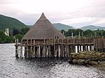
A crannog is typically a partially or entirely artificial island, usually built in lakes and estuarine waters of Scotland, Wales, and Ireland. Unlike the prehistoric pile dwellings around the Alps, which were built on the shores and not inundated until later, crannogs were built in the water, thus forming artificial islands.

<span class="mw-page-title-main">Loch Lubnaig</span> Loch in Stirling, Scotland, UK

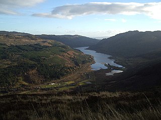
Loch Lubnaig is a small freshwater loch near Callander in the Stirling council area, Scottish Highlands. It lies in the former county of Perthshire. It is part of the Loch Lomond and The Trossachs National Park.

<span class="mw-page-title-main">Loch Tay</span> Freshwater loch in the central highlands of Scotland

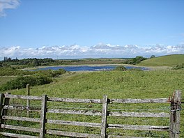
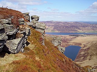
Loch Tay is a freshwater loch in the central highlands of Scotland, in the Perth and Kinross and Stirling council areas. It is the largest body of fresh water in Perth and Kinross, and the sixth largest loch in Scotland. The watershed of Loch Tay traditionally formed the historic province of Breadalbane.

<span class="mw-page-title-main">Loch Shiel</span> Freshwater loch in Scotland

Loch Shiel is a freshwater loch situated 20 kilometres (12 mi) west of Fort William in the Highland council area of Scotland. At 28 kilometres long it is the 4th longest loch in Scotland, and is the longest to have retained a natural outflow without any regulation of its water level, being 120 m (393 ft) deep. Its nature changes considerably along its length, being deep and enclosed by mountains in the north east and shallow surrounded by bog and rough pasture in the south west, from which end the 4 km River Shiel drains to the sea in Loch Moidart near Castle Tioram.

<span class="mw-page-title-main">Loch Tummel</span> Body of water

Loch Tummel is a long, narrow loch, seven kilometres northwest of Pitlochry in the council area of Perth and Kinross, Scotland. It is fed and drained by the River Tummel, which flows into the River Tay about 13 km (8 mi) south-east of the Clunie Dam at the loch's eastern end.

<span class="mw-page-title-main">Loch Kinord</span> A lake in Aberdeenshire, Scotland

Loch Kinord is a small, freshwater loch at Muir of Dinnet, Aberdeenshire, Scotland just north of the River Dee and 5 mi (8 km) east of Ballater. The loch is also known as Loch Ceander and Loch Cannor. It is approximately 1 mi (1.6 km) in length and was formed from a glacial kettle hole. The loch sits within the Muir of Dinnet National Nature Reserve and is immediately south of Loch Davan.

<span class="mw-page-title-main">Loch Ness</span> Lake in Scotland, United Kingdom

Loch Ness is a large freshwater loch in the Scottish Highlands extending for approximately 37 kilometres southwest of Inverness. It takes its name from the River Ness, which flows from the northern end. Loch Ness is best known for claimed sightings of the cryptozoological Loch Ness Monster, also known affectionately as "Nessie". It is one of a series of interconnected, murky bodies of water in Scotland; its water visibility is exceptionally low due to a high peat content in the surrounding soil. The southern end connects to Loch Oich by the River Oich and a section of the Caledonian Canal. The northern end connects to Loch Dochfour via the River Ness, which then ultimately leads to the North Sea via the Moray Firth.

<span class="mw-page-title-main">Dùn Anlaimh</span>

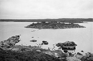
Dùn Anlaimh, also known as Dùn Amhlaidh, and Eilean nan Cinneachan, is a crannog, located within Loch nan Cinneachan on the Inner Hebridean island of Coll. Upon the crannog there are the remains of walls and several buildings. These remains are not unlike those of other fortified islands found throughout the Outer Hebrides, and it is likely that Dùn Anlaimh dates from the late Middle Ages. According to local tradition on Coll, the fort was once the home of a Norse chieftain who was defeated in battle somewhere nearby. The early 20th century antiquary Erskine Beveridge considered it as one of the four most interesting fortifications, on Coll. The site of Dùn Anlaimh is located at grid reference NM18845684. The RCAHMS classifies the site as a 'crannog' and an 'island dwelling'.

The Breachacha crannog is a crannog located near Loch Breachacha, on the Inner Hebridean island of Coll. The crannog is recognised in the United Kingdom as a Scheduled monument. A scheduled monument is a 'nationally important' archaeological site or historic building, given legal protection against unauthorised change. There are about 8,000 such sites in Scotland.

<span class="mw-page-title-main">Loch Sgadabhagh</span> Body of water

Loch Sgadabhagh or Loch Scadavay is a body of water on the island of North Uist, Scotland. The name may be of Old Norse derivation meaning "lake of tax bay" although if so, the reason is obscure. Loch Sgadabhagh is the largest loch by area on North Uist although Loch Obisary has about twice the volume.

<span class="mw-page-title-main">Buiston Loch</span> An occasional lake in Ayrshire, Scotland

Buiston Loch, also known as Buston, Biston, and Mid Buiston was situated in the mid-Ayrshire clayland at an altitude of 90 m OD. The loch was natural, sitting in a hollow created by glaciation. The loch waters drained via the Garrier Burn that joins the Bracken and Lochridge Burns before joining the River Irvine.

<span class="mw-page-title-main">Martnaham Loch</span> Body of water

Martnaham Loch is a freshwater loch lying across the border between East and South Ayrshire Council Areas, two kilometres from Coylton, in the parishes of Coylton and Dalrymple, three miles from Ayr. The loch lies along an axis from northeast to southwest. The remains of a castle lie on a possibly artificial islet within the loch. The Campbells of Loudoun once held the lands, followed by the Kennedys of Cassillis.

Old Luce is a civil parish in Dumfries and Galloway, Scotland. It lies in the Machars peninsula, in the traditional county of Wigtownshire. The parish is around 10 miles (16 km) long and 8 miles (13 km) broad, and contains 40,350 acres (16,330 ha).

<span class="mw-page-title-main">Loch Bà (Rannoch Moor)</span> A lake in Argyll and Bute, Scotland

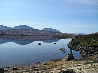
Loch Bà is a shallow irregular shaped freshwater loch on Rannoch Moor, Argyll and Bute, in the Scottish West Highlands, within the Highland council area of Scotland. It is about 25 km east-south-east of Glen Coe, and 20 km north of Tyndrum.

<span class="mw-page-title-main">Loch Achilty</span> A lake in Ross-shire, Scotland

Loch Achilty is a large picturesque lowland freshwater loch set within a sloping birch and oakwood forest, and located near to Contin in Ross-shire, Scottish Highlands, Scotland. Loch Achilty is notable for having no outflow. It has been assumed that it is discharging its surplus water via tunnel into the River Rosay that eventually flows into the larger River Conon.

<span class="mw-page-title-main">Loch Kennard</span> Body of water

Loch Kennard is freshwater loch located south-east of Aberfeldy, situated on Grandtully Hill in Perth and Kinross within Griffin Forest in Scotland.

<span class="mw-page-title-main">Loch Freuchie</span> A lake in Perth and Kinross, Scotland

Loch Freuchie, also known as Fraoch, the heatherly loch, is a large freshwater loch on a north-west to south-east orientation, within Glen Quaich in Perth and Kinross. The loch is located 2 miles (3.2 km) west of Amulree and 6.5 miles (10.5 km) southeast of Kenmore.

<span class="mw-page-title-main">Loch Turret</span> A lake in Perth and Kinross, Scotland

Loch Turret is a large freshwater reservoir on a north-east to south-west orientation, that is located at the head of Glen Turret and 5.39 miles (8.67 km) northwest of Crieff in Perth and Kinross.

<span class="mw-page-title-main">Loch Beanie</span> Body of water

Loch Beanie also known as Loch Shechernich, is a small shallow freshwater loch that is located in Glen Shee in Perth and Kinross, Scotland.

<span class="mw-page-title-main">Loch Sionascaig</span> Body of water

Loch Sionascaig is a large irregular shaped, freshwater loch in the remote Coigach area of northern Wester Ross. It is located 5.5 miles southeast of the village of Lochinver and is situated within the Inverpolly Forest.

References

  1. "Barhapple Loch". British Lakes. Retrieved 24 February 2018.
  2. 1 2 3 4 5 Robert Munro (1882). Ancient Scottish Lake-Dwellings – Or Crannogs with a Supplementary Chapter on Remains of Lake-Dwellings in England. Read Books Limited. p.  185. ISBN   978-1-4733-8718-8 . Retrieved 24 February 2018.PD-icon.svg This article incorporates text from this source, which is in the public domain .
  3. John, Murray; Lawrence, Pullar (1910). Bathymetrical Survey of the Fresh-Water Lochs of Scotland, 1897-1909 Lochs of the Tay Basin Volume II - Loch of Butterstone. National Library of Scotland: National Challenger Officer. p. 102. Retrieved 12 January 2018.PD-icon.svg This article incorporates text from this source, which is in the public domain .
  4. "Barhapple Loch". The Editors of The Gazetteer for Scotland. School of GeoSciences, University of Edinburgh and The Royal Scottish Geographical Society. Retrieved 1 March 2018.
  5. Society of Antiquaries of Scotland (1873). Proceedings of the Society of Antiquaries of Scotland. Society of Antiquaries of Scotland. p. 377. Retrieved 26 February 2018.
  6. 1 2 3 "Barhapple Loch". Canmore National Record of the Historic Environment. Historic Environment Scotland. Retrieved 26 February 2018.
  7. John, Murray; Lawrence, Pullar (1910). Bathymetrical Survey of the Fresh-Water Lochs of Scotland, 1897–1909 Lochs of the Tay Basin Volume I – Barhapple Loch. National Library of Scotland: National Challenger Officer. p. 242.