Skellow is a village in the Doncaster district, in the county of South Yorkshire, England. Historically part of the West Riding of Yorkshire, the village is roughly 5 miles (8 km) north-west of Doncaster. The village falls in the Askern Spa Ward of Doncaster MBC. To the north and south is mixed farmland, the A1 runs immediately along the western edge of the village, and to the east Skellow merges with the adjacent village of Carcroft along the B1220 road.

Barnby Dun with Kirk Sandall is a civil parish in the Metropolitan Borough of Doncaster in South Yorkshire, England. According to the 2001 census it had a population of 8,524 and by 2011 this had risen to 8,592. The parish covers Barnby Dun and Kirk Sandall, both parts of the Doncaster urban area.

Strafforth and Tickhill, originally known as Strafforth, was the southernmost wapentake in the West Riding of Yorkshire, England. The west of the district, plus a detached area in the east, constituted the Upper Division, while the central area and a detached part in the extreme east constituted the Lower Division.

Preston or Preston Village is a suburb of Brighton and Hove, in the ceremonial county of East Sussex, England. It is to the north of the centre. Originally a village in its own right, it was eventually absorbed into Brighton with the development of the farmland owned by the local Stanford family, officially becoming a parish of the town in 1928. Stanford-owned land to the south of Preston Manor was given to the town and now makes up Preston Park, one of the largest parks in the now conjoined city of Brighton and Hove. The park hosts some of the city's major public events such as Brighton Pride.
Fangfoss is a village and civil parish in the East Riding of Yorkshire, England. It is situated approximately 11 miles (18 km) to the east of the city of York and 3.5 miles (6 km) north-west of the town of Pocklington. The parish includes Bolton. The civil parish is called "Fangfoss" and its parish council is called "Fangfoss with Bolton Parish Council" after Bolton parish was abolished on 1 April 1935 and merged with Fangfoss. The parish covers an area of 900.98 hectares. In 2011 it had a population of 581, a decrease on the 2001 UK census figure of 602.
Bolton upon Dearne is a village in the Metropolitan Borough of Barnsley, South Yorkshire, England, in the part of the Dearne Valley through which the River Dearne passes. Historically part of the West Riding of Yorkshire, it is approximately 7 miles (11 km) east of Barnsley, 10 miles (16 km) west of Doncaster and 8 miles (13 km) north of Rotherham.
The South Yorkshire Railway was a railway company with lines in the West Riding of Yorkshire, England.

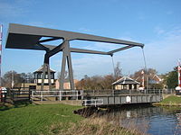
Bramwith (WR&G) railway station, which was named Barnby Dun on opening, believed to be 1872, due to its close proximity to the village of that name, took the name Bramwith,, from the village of Kirk Bramwith, near Doncaster, South Yorkshire, England although it was over two miles away. This was possibly to avoid confusion with the station rebuilt on the Manchester, Sheffield and Lincolnshire Railway's straightened line between Doncaster and Thorne. The station was also closer to the village of Thorpe-in-Balne, to the north, than Kirk Bramwith. It was located at the level crossing near the junction of North Field Lane with Bramwith Lane, east of the River Don Navigation.
Lowthorpe is a village and former civil parish, now in the parish of Harpham, in the East Riding of Yorkshire, England. It is situated approximately 3 miles (5 km) north-east of Driffield town centre and 7 miles (11 km) south-west of Bridlington town centre. In 1931 the parish had a population of 159. On 1 April 1935 the parish was abolished and merged with Harpham.

Burnby is a village and former civil parish, now in the parish of Hayton, in the East Riding of Yorkshire, England. It is situated approximately 2.5 miles (4 km) south-east of the market town of Pocklington and 4 miles (6.4 km) north-west of the market town of Market Weighton. It lies 1 mile (1.6 km) to the east of the A1079 road. In 1931 the parish had a population of 103. On 1 April 1935 the parish was abolished and merged with Hayton.

Harswell is a village and former civil parish, now in the parish of Everingham, in the East Riding of Yorkshire, England. It is approximately 3.5 miles (5.6 km) west of Market Weighton town centre, 5 miles (8 km) south of Pocklington town centre, and 1 mile (1.6 km) west of the A614 road. In 1931 the parish had a population of 78.
Goxhill is a small hamlet in the civil parish of Hatfield, in the East Riding of Yorkshire, England in an area known as Holderness. It is situated approximately 2 miles (3.2 km) south-west of Hornsea town centre. In 1931 the parish had a population of 70.

Arksey is a village in the City of Doncaster in South Yorkshire, England. It had an estimated population of 1,303 as of 2010. It was the birthplace of the children's writer Barbara Euphan Todd on 9 January 1890. Arksey has four satellite hamlets: Shaftholme, Tilts, Almholme and Stockbridge.

Wharram-le-Street is a village and former civil parish, now in the parish of Wharram, in North Yorkshire, England.

Edenthorpe is a village and civil parish on the eastern edge of Doncaster, South Yorkshire, England. At the 2001 census, it had a population of 4,752, increasing slightly to 4,776 at the 2011 Census. The village lies 4 miles (6.4 km) to the north east of Doncaster city centre.
Kirk Sandall is an outer suburb of Doncaster, located around 4 miles (6.4 km) north-east of the city centre, in the civil parish of Barnby Dun with Kirk Sandall, in the county of South Yorkshire, England.
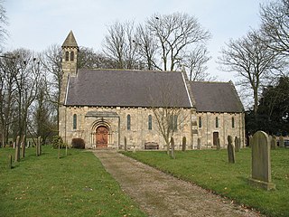
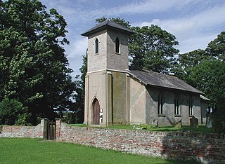
St Oswald's Church is a redundant Anglican church in Kirk Sandall, near Doncaster, South Yorkshire, England. It is recorded in the National Heritage List for England as a designated Grade II* listed building, and is under the care of the Churches Conservation Trust.
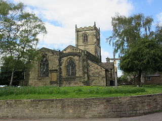
Barnby Dun with Kirk Sandall is a civil parish in the metropolitan borough of Doncaster, South Yorkshire, England. The parish contains four listed buildings that are recorded in the National Heritage List for England. Of these, one is listed at Grade I, the highest of the three grades, one is at Grade II*, the middle grade, and the others are at Grade II, the lowest grade. The parish contains the villages of Barnby Dun and Kirk Sandall, and the surrounding area. The listed buildings consist of two churches, a churchyard cross, and a barn and cart shed.

Thorpe Marsh Nature Reserve is a 77-hectare (190-acre) nature reserve located south-west of Thorpe in Balne, north of Doncaster in South Yorkshire, England. The reserve is managed and maintained by a team of volunteers under the Yorkshire Wildlife Trust as well as Doncaster Metropolitan Borough Council.