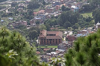
Barpak is one of the largest villages in Nepal, situated within the Barpak Sulikot Rural Municipality, specifically in ward two. It has always been a popular tourist destination due to its stunning landscape atop a hill, adorned with thickly clustered local houses crafted from materials like stone and wood. The village boasts a view of the Ganesh Himal range, enhancing its allure.
Barpark is also known by the village of Gaje Ghale who is a Nepalese Gurkha recipient of the Victoria Cross. Barpak itself being one of the biggest local market, center for the health, education and more for the people of other small villages around Barpak.
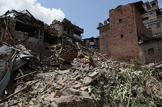
Being close to the epicentre and lodged on a steep hillside, the village was extremely hard hit by the April 2015 Nepal earthquake.[2] Reports say less than 10 of 1,200 homes remain standing.[3]
Related Research Articles
The Tamang, are a Tibeto-Burman ethnic group of Nepal, Southern Bhutan and North India. In Nepal, Tamang people constituted 5.6% of the Nepalese population at over 1.3 million in 2001, increasing to 1,539,830 as of the 2011 census. The Tamang people are concentrated in the central hilly region and himalayan region of Nepal. Indian Tamangs are found in significant numbers in the state of Sikkim and the districts of Darjeeling and Kalimpong in West Bengal state. Bhutanese Tamangs are native to various districts in the southern foothills of the Kingdom of Bhutan. Such districts include the Tsirang District, the Dagana District, the Samtse District, the Chukha District, the Sarpang District and the Samdrup Jongkhar District. Tamang language is the fifth most-spoken language in Nepal.
Langtang Valley also known as Lamtang Valley is a Himalayan valley in the mountains of north-central Nepal, known for its trekking routes and natural environment.
Gandaki zone was one of the fourteen zones of Nepal, located in the Western Development Region. It was named as Sapta Gandaki after the seven tributaries that makes up the Gandaki River. Pokhara served as its regional and zonal headquarter. It was also the birthplace of Bhanubhakta Acharya, first poet of Nepal.
The Shah dynasty, also known as the Shahs of Gorkha or the Royal House of Gorkha, was the ruling Chaubise Thakuri dynasty and the founder of the Gorkha Kingdom from 1559 to 1768 and later the unified Kingdom of Nepal from 1768 to 28 May 2008.
Dhading District, a part of Bagmati Province, is one of the seventy-seven districts of Nepal. The district, with Dhading Besi as its district headquarters, covers an area of 1,926 square kilometres (744 sq mi), had a population of 338,658 in 2001 and 336,067 in 2011.
Gorkha District, a part of Gandaki Province, is one of 77 districts of Nepal, and the fourth largest district of the country in terms of area. It is historically linked with the creation of modern Nepal and the name of the legendary Gorkha soldiers. The district, with Gorkha Municipality as its district headquarters, covers an area of 3,610 km2 (1,390 sq mi) and has a population of 252,201, according to the 2021 Nepal census. Gorkha district is the site of the Manakamana Temple, as well as Gorakhnath and Gorakh Kali temples. Several major rivers—including the Chepe, Daraudi, Marsyangdi, Budi Gandaki, and Trishuli—run through the district.
Lamjung District, a part of Gandaki Province, is one of the 77 districts of Nepal. The district, with Besisahar as its district headquarters, covers an area of 1,692 square kilometres (653 sq mi) and as of 2011 had a population of 167,724. Lamjung lies in the mid-hills of Nepal spanning tropical to trans-Himalayan geo-ecological belts, including the geographical midpoint of the country. It has mixed habitation of casts and ethnicities. It is host to probably the highest density of the Gurung ethnic population in the country.
Sindhupalchowk District is a part of Bagmati Province and one of the seventy-seven districts of Nepal, with an area of 2,542 km2 (981 sq mi). The district's headquarters is in Chautara. In 2006, 336,478 people resided in 79 village development committees, in 2011 there were 287,798.
Gorkha is a municipality in Gorkha District in Gandaki Province of Nepal created in 1996. It was initially named "Prithvinarayan" after King Prithvi Narayan Shah, who was born in Gorkha and united and founded modern Nepal. In 2009, the name was changed to "Gorkha" municipality after the end of the monarchy in Nepal. At the time of the 2021 Nepal census it had a population of 53,285 people living in 12,641 individual households. In 2014, the neighboring Village development committees Nareshwar and Phinam were merged into the municipality.
Jaubari was a Village Development committee in Gorkha District in the Gandaki Zone of northern-central Nepal. At the time of the 1991 Nepal census it had a population of 3,398 and had 658 houses in the town. It is located at the western part of Gorkha district. Marichman Shrestha, former VDC chairperson, and social worker is from Jaubari-7, Gorkha. Freedom fighter late Rohini Dev Bhatta is also from the village as well as his daughter Dr. Madhabi Bhatta, who is a former commissioner of the Truth and Reconciliation Commission, Nepal. Jaubari is one of the major hubs for education and health in Gorkha District. Paropakar Adarsha Uccha Madhyamik Vidhalaya is located in Jaubari VDC of Gorkha.
Saurpani is Ward no.4 of Barpak Sulikot Rural Municipality in Gorkha District in the Gandaki Province of northern-central Nepal. At the time of the 2011 Nepal census it had a population of 5,958 and had 1,325 houses in the town.
Takukot is a Ward of Barpak sulikot Rural Municipality in Gorkha District in the Gandaki Province of northern-central Nepal. At the time of the 1991 Nepal census it had a population of 4,234 and had 801 houses in the town.
Barpak is a village development committee in Gorkha District in the Gandaki Zone of northern-central Nepal. It is centered on the village of Barpak. At the time of the 1991 Nepal census it had a population of 4,556 and had 888 houses.
Dr Shesh Ghale is a Nepali Australian businessman, billionaire and the former president of Non Resident Nepali Association (NRNA). Based in Melbourne, Victoria, Ghale is the CEO of Melbourne Institute of Technology (MIT), which he co-founded with his wife, Jamuna Gurung.
The April 2015 Nepal earthquake killed 8,962 people in Nepal and injured 21,952 more. It occurred at on Saturday 25 April 2015, with a magnitude of 7.8Mw or 8.1Ms and a maximum Mercalli Intensity of X (Extreme). Its epicenter was east of Gorkha District at Barpak, Gorkha, roughly 85 km (53 mi) northwest of central Kathmandu, and its hypocenter was at a depth of approximately 8.2 km (5.1 mi). It was the worst natural disaster to strike Nepal since the 1934 Nepal–India earthquake. The ground motion recorded in Kathmandu, the capital of Nepal, was of low frequency, which, along with its occurrence at an hour when many people in rural areas were working outdoors, decreased the loss of human lives.
Ram Shah was king of the Gorkha Kingdom. He was the son of Gorkha king Purna Shah and brother of Chatra Shah. He acceded to the throne c. 1606 after his brother's death. He expanded his kingdom far as the Trishuli River (east), the Marshyangdi (west), the Rasuwa, (north) and the Mahabharat Range (west).
Tsum Nubri Rural Municipality is a rural municipality situated at the borderline of nepal and china in Gorkha District in Gandaki Province of Nepal. It is divided into 7 wards.
Dharche Rural Municipality is a Gaunpalika in Gorkha District in Gandaki Province of Nepal. It is divided into 7 wards. On 12 March 2017, the government of Nepal implemented a new local administrative structure, with the implementation of the new local administrative structure, VDCs have been replaced with municipal and Village Councils. Dharche is one of these 753 local units.
Arughat Rural Municipality is a Gaunpalika in Gorkha District in Gandaki Province of Nepal. It is divided into 10 wards. On 12 March 2017, the government of Nepal implemented a new local administrative structure, with the implementation of the new local administrative structure, VDCs have been replaced with municipal and Village Councils. Arughat is one of these 753 local units.
The 1833 Nepal–India earthquake occurred on August 26 at 22:58 local time (NPT). This earthquake had an estimated moment magnitude of 7.6–7.9 and struck with an epicenter somewhere in or near the Kathmandu Valley. The earthquake caused major destruction in numerous towns and villages in Nepal, northern India, and Tibet. The earthquake was also felt in Chittagong, Bangladesh. Despite the extent of the damage, the number of fatalities resulting from the earthquake was surprisingly low, at approximately 500. This was because the mainshock was preceded by two smaller but intense foreshocks earlier that day, causing many residents to take refuge outside their homes.
This page is based on this Wikipedia article Text is available under the CC BY-SA 4.0 license; additional terms may apply. Images, videos and audio are available under their respective licenses.