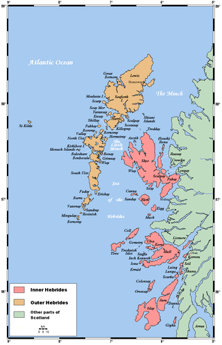
The Hebrides are an archipelago off the west coast of the Scottish mainland. The islands fall into two main groups, based on their proximity to the mainland: the Inner and Outer Hebrides.
The Outer Hebrides or Western Isles, sometimes known as the Long Isle or Long Island, is an island chain off the west coast of mainland Scotland. The islands are geographically coextensive with Comhairle nan Eilean Siar, one of the 32 unitary council areas of Scotland. They form part of the archipelago of the Hebrides, separated from the Scottish mainland and from the Inner Hebrides by the waters of the Minch, the Little Minch, and the Sea of the Hebrides.

Barra is an island in the Outer Hebrides, Scotland, and the second southernmost inhabited island there, after the adjacent island of Vatersay to which it is connected by the Vatersay Causeway. The island is named after Saint Finbarr of Cork.

The island of Vatersay is the southernmost and westernmost inhabited island in the Outer Hebrides of Scotland, and the settlement of Caolas on the north coast of the island is the westernmost permanently inhabited place in Scotland. The main village, also called Vatersay, is in the south of the island.
Mingulay is the second largest of the Bishop's Isles in the Outer Hebrides of Scotland. Located 12 nautical miles south of Barra, it is known for an extensive Gaelic oral tradition incorporating folklore, song and stories and its important seabird populations, including puffins, black-legged kittiwakes, and razorbills, which nest in the sea-cliffs, amongst the highest in the British Isles.
Barra Head, also known as Berneray, is the southernmost island of the Outer Hebrides in Scotland. Within the Outer Hebrides, it forms part of the Barra Isles archipelago. Originally, Barra Head only referred to the southernmost headland of Berneray but is now a common name for the entire island. The highest point of the island is Sotan, a Marilyn.
Sandray is one of the Barra Isles in the Outer Hebrides of Scotland. It never had a large population, and has been uninhabited since 1934. It is now known for its large seabird colony.

Garbh Sgeir is a rock about 100 metres west of the islet Òigh-sgeir, in the Small Isles, Lochaber, Scotland. There is an anchorage between the two.

Castlebay is the main village and a community council area on the island of Barra in the Outer Hebrides, Scotland. The village is located on the south coast of the island, and overlooks a bay in the Atlantic Ocean dominated by Kisimul Castle, as well as nearby islands such as Vatersay. Castlebay is also within the parish of Barra. The village is located on the A888, which serves as a circular road around Barra. In 1971 it had a population of 307.
There are many small islands in Scotland called Flodday or similar and this list provides a guide to their location. The derivation of the name is from the Old Norse floti meaning "raft" or "float". The similar island names Fladda and Flotta are also from the Norse flatr and mean "flat island". Usage is not always consistent in external sources.
Biruaslum or Bioruaslam is a stack in the Barra Isles of Scotland, to the west of Vatersay. Approximately 2.5 kilometres from the nearest road, it reaches 72 m (236 ft) in height and there is a ruined prehistoric fort on the southern side. Francis G. Thompson characterizes it as "high and virtually inaccessible"; James Fisher mentions a "fulmar flying up and down its tiny cliff."

Fuiay is an island in Scotland. It is one of ten islands in the Sound of Barra, a Site of Community Importance for conservation in the Outer Hebrides. Its area is 84 ha and the unnamed highest eminence reaches 107 m. It is located immediately to the west of Flodday and about 1.5 km southwest of Hellisay. Barra lies across the waters of North Bay.
The Outer Hebrides are a unique religious area in contemporary Scotland. The northern island is dominated by Calvinist 'free churches', and has been described as "the last bastion of Sabbath observance in the UK". It is also home to a unique form of Gaelic psalm singing known as precenting. The southern islands of South Uist and Barra are the last remnants of native pre-Reformation Scottish Catholicism. Barra was once dubbed "the island the Reformation did not reach".

The Vatersay Causeway is a 250-metre-long causeway that links the Scottish Hebridean Islands of Vatersay and Barra across the Sound of Vatersay.

