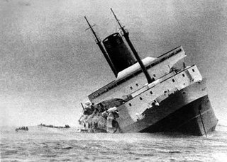
TEV Wahine was a twin-screw, turbo-electric, roll-on/roll-off ferry. Ordered in 1964, the vessel was built by the Fairfield Shipbuilding and Engineering Company, in Govan, Glasgow, Scotland for the Union Steam Ship Company's Wellington-Lyttelton Steamer Express Service in New Zealand. The ship's name, Wahine, is a word for 'woman' in some Polynesian languages, including Māori.
Te Whanganui-a-Tara is the Māori name for Wellington Harbour. The term is also used to refer to the city of Wellington, the capital city of New Zealand, which lies on the shores of the harbour. Te Whanganui-a-Tara translates as "the great harbour of Tara", named for Tara, a son of Polynesian explorer Whatonga, whose descendants lived in the area.

Lambton Quay is the heart of the central business district of Wellington, the capital city of New Zealand.

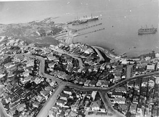
Seatoun, an eastern suburb of Wellington, the capital city of New Zealand, lies on the east coast of the Miramar Peninsula, close to the entrance to Wellington Harbour, some seven kilometres southeast of the CBD. The suburb sits on an exposed promontory close to Barrett Reef, a dangerous area of rocky shallows upon which many ships have foundered, most notably the inter-island ferry TEV Wahine in 1968.
Sir Charles Hardy Islands is in the reef of the same name adjacent to Pollard Channel & Blackwood Channel about 40 km east of Cape Grenville off Cape York Peninsula.

Booby Island is located 45 km (28 mi) northwest of Muttee Heads at the tip of Cape York Peninsula in Queensland, Australia. This island is in the Torres Strait, 32 km (20 mi) west of Thursday Island and 23 km (14 mi) west of Prince of Wales Island. Booby Island is also known as Ngiangu by the Kuarareg people of the western Torres Strait, its traditional owners, named for the giant Ngiangu who was forced from a neighbouring island It has been called Booby Island by a number of European explorers, including Captain Cook, for the presence of the booby birds.

Kaiwharawhara is an urban seaside suburb of Wellington in New Zealand's North Island. It is located north of the centre of the city on the western shore of Wellington Harbour, where the Kaiwharawhara Stream reaches the sea from its headwaters in Karori. It is a largely commercial and industrial area and thus has little residential population. A recent housing development up the hillside towards Te Kainga has increased the resident population.
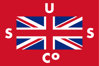
Union Steam Ship Company of New Zealand Limited —when there was no chance of confusion casually referred to as Union, Union Company, Union Steam Ship Company, or Union Line— was once the biggest shipping line in the southern hemisphere and New Zealand's largest private-sector employer. It was incorporated by James Mills in Dunedin in 1875 with the backing of a Scottish shipbuilder, Peter Denny. Bought by shipping giant P & O around the time of the First World War it was sold in 1972 to an Australasian consortium and closed at the end of the twentieth century.

Steeple Rock/Te Aroaro-o-Kupe is a large rock off Seatoun at the west of the entrance to Wellington Harbour, rising 7 metres (23 ft) above sea level. The rock plays a role in warning ships off the coast. It is the location of a marine light and an unbeaconed trig station.

The islands and reefs of the Capricorn and Bunker Group are situated astride the Tropic of Capricorn at the southern end of the Great Barrier Reef, approximately 80 kilometres east of Gladstone, which is situated on the central coast of the Gladstone Region, Queensland, Australia.
Henry Niccol was probably the first shipbuilder in Auckland, New Zealand. He was born in 1819 in Greenock. He was the father of George Turnbull Niccol and Malcolm Niccol.
Evans Bay, located in Wellington Harbour, New Zealand, between the Miramar Peninsula and Hataitai, was the site of New Zealand's first patent slip and served as Wellington's international flying-boat terminal from 1938 until 1956. It is named after George Samuel Evans, an early Wellington settler.
Marchioness was a brigantine built at Waterford, Ireland in 1851 and registered at Melbourne that sailed between Nelson, New Zealand and Melbourne, Australia in the 1850s. It foundered on rocks off the Taranaki coast in 1864 and was lost with no loss of life, having previously grounded twice, once off the coast of Victoria, Australia, and once in Cook Strait.

The New Zealand Company was a 19th-century English company that played a key role in the colonisation of New Zealand. The company was formed to carry out the principles of systematic colonisation devised by Edward Gibbon Wakefield, who envisaged the creation of a new-model English society in the southern hemisphere. Under Wakefield's model, the colony would attract capitalists who would then have a ready supply of labour—migrant labourers who could not initially afford to be property owners, but who would have the expectation of one day buying land with their savings.

The Wanganui was an iron Brigantine Twin Boiler Screw steamer built by Gourlay Brothers & Co and launched in July 1863 for the Wanganui Steam Navigation Company for trade around the Wanganui region of New Zealand. The vessel served in this region up to 1873 when its ownership was transferred to Messrs Henry Houghton and Co., of Dunedin. In 1880 the vessel was transferred in to the Australian East coast service where it sank whilst entering Clarence River on 20 June 1880.
