Tucson is a city in and the county seat of Pima County, Arizona, United States, and is home to the University of Arizona. It is the second-largest city in Arizona behind Phoenix, with a population of 542,629 in the 2020 United States census, while the population of the entire Tucson metropolitan statistical area (MSA) is 1,043,433. The Tucson MSA forms part of the larger Tucson-Nogales combined statistical area. Both Tucson and Phoenix anchor the Arizona Sun Corridor. The city is 108 miles (174 km) southeast of Phoenix and 60 mi (100 km) north of the United States–Mexico border.

The Southwestern United States, also known as the American Southwest or simply the Southwest, is a geographic and cultural region of the United States that includes Arizona and New Mexico, along with adjacent portions of California, Colorado, Nevada, Oklahoma, Texas, and Utah. The largest cities by metropolitan area are Phoenix, Las Vegas, El Paso, Albuquerque, and Tucson. Before 1848, in the historical region of Santa Fe de Nuevo México as well as parts of Alta California and Coahuila y Tejas, settlement was almost non-existent outside of Nuevo México's Pueblos and Spanish or Mexican municipalities. Much of the area had been a part of New Spain and Mexico until the United States acquired the area through the Treaty of Guadalupe Hidalgo in 1848 and the smaller Gadsden Purchase in 1854.

Old San Juan is a historic district located at the "northwest triangle" of the islet of San Juan in San Juan. Its area roughly correlates to the Ballajá, Catedral, Marina, Mercado, San Cristóbal, and San Francisco sub-barrios (sub-districts) of barrio San Juan Antiguo in the municipality of San Juan, Puerto Rico. Old San Juan is the oldest settlement within Puerto Rico and the historic colonial district of the city of San Juan. This historic district is a National Historic Landmark District named Zona Histórica de San Juan and is listed on the United States National Register of Historic Places as the Old San Juan Historic District. Several historical buildings and structures, particularly La Fortaleza, the city walls, and El Morro and San Cristóbal castles, have been inscribed in the UNESCO World Heritage Site list since 1983. Historically the mixed-use commercial and residential real estate in the main streets of Calle Cristo and Calle Fortaleza from Calle Tanca to the Governor’s Mansion is the most valuable in the area and it has kept its value and increased steadily through several years despite the past economic turmoils.

Casa Grande Ruins National Monument, in Coolidge, Arizona, located northeast of Casa Grande, Arizona, preserves a group of Hohokam structures dating to the Classic Period (1150–1450 CE).

The Spanish missions in the Sonoran Desert are a series of Jesuit Catholic religious outposts established by the Spanish Catholic Jesuits and other orders for religious conversions of the Pima and Tohono O'odham indigenous peoples residing in the Sonoran Desert. An added goal was giving Spain a colonial presence in their frontier territory of the Sonora y Sinaloa Province in the Viceroyalty of New Spain, and relocating by Indian Reductions settlements and encomiendas for agricultural, ranching, and mining labor.

El Tiradito is a shrine and popular local spot located at 420 South Main Avenue in the Old Barrio area of Downtown Tucson, Arizona. Because of the site's association with pleas for supernatural intervention, it is also called the Wishing Shrine. The legends surrounding the site center around a broken-hearted man dying and, due to a sin, being unable to be buried on consecrated ground. The legends date to the 1870s, and the shrine has been present since at least 1891. Its name comes from the Spanish "tirar." The shrine was the first Arizona property to be placed on the National Register of Historic Places for its traditional cultural values. It is especially important to Tucson's Mexican and Mexican American communities.
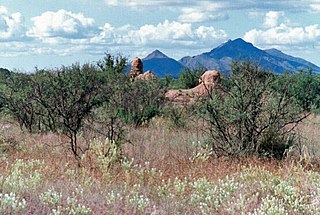
La Misión de San Gabriel de Guevavi was founded by Jesuit missionary priests Eusebio Kino and Juan María de Salvatierra in 1691. Subsequent missionaries called it San Rafael and San Miguel, resulting in the common historical name of Mission Los Santos Ángeles de Guevavi.
Josias Thomas Joesler was a Swiss-American architect who later worked and eventually died in Tucson, Arizona.
Henry O. Jaastad (1872–1965) was an influential Tucson, Arizona architect. His firm created over 500 buildings and Jaastad was Mayor of Tucson for 14 years. A number of his works are listed on the U.S. National Register of Historic Places for their architecture.
Kol Ami is a Reform Jewish congregation and synagogue located at 225 North Country Club Road, in Tucson, Arizona, in the United States. The congregation was formed through the 2019 merger of Temple Emanu-El and the Congregation Or Chadash, that was established in 1995. The leaders of Temple Emanuel-El and Congregation Or Chadash began discussions about a potential merger in 2018. The merger of the two Reform congregations was consummated the following year, as Kol Ami.
Fort Lowell was a United States Army post active from 1873 to 1891 on the outskirts of Tucson, Arizona. Fort Lowell was the successor to Camp Lowell, an earlier Army installation. The Army chose a location just south of the confluence of the Tanque Verde and Pantano creeks, at the point where they form the Rillito River, due to the year-round supply of water during that period. The Hohokam natives had chosen the site centuries earlier, presumably for the same reason. To this day, shards of Hohokam pottery can still be found in the area. The Army claimed a military reservation that encompassed approximately eighty square miles and extended east toward the Rincon Mountains.

The Chicano Art Movement represents groundbreaking movements by Mexican-American artists to establish a unique artistic identity in the United States. Much of the art and the artists creating Chicano Art were heavily influenced by Chicano Movement which began in the 1960s.
Throughout its history, Tucson, Arizona has had a large and influential Mexican American community. Tucson was majority Mexican/Mexican American even by the early 20th century.
Guillermo Acevedo (1920-1988) was a Peruvian-born artist and master draftsman, most famous in the United States for his striking portrayal of Native Americans of the Southwest, and for his ability to capture and help preserve the disappearing architectural styles of old neighborhoods throughout the U.S. and abroad. Known to be an artist-observer with great sensitivity, Acevedo is recognized as a master at recording the human condition.
Pinckney Randolph Tully was an American businessman and politician who served as Arizona Territorial Treasurer and Mayor of Tucson, Arizona Territory.
Lydia R. Otero is an Chicanx/Latinx historian and author. They are known for their work on marginalized communities in Arizona.

María Luisa Legarra Urquides was an American educator and proponent of bilingual education. She spent her life in the US state of Arizona, but influenced national educational policies. Urquides served in local and federal roles, and received numerous awards and recognitions for her educational leadership and community work. She has been referred to as the "Mother of Bilingual Education" in the United States. She was inducted into the Arizona Women's Hall of Fame in 2002.

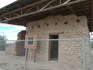
El Cuartel Viejo is a significant and important example of Pueblo Revival architecture in the American Southwest. Rebuilt starting in 1942 from the ruins of the 1870s Fort Lowell Quartermaster and Commissary Storehouse the design-build project was led by Dutch-born artist Charles Bolsius, with brother and sister-in-law Nan and Pete Bolsius. The project, a series of five residences, included distinctive hand-carved Bolsius doors, exposed beams, carved corbels, adobe fireplaces, hand-hammered tin, and a heightened sense of romanticism. The property like Las Saetas to the west and its transformation over a 150-year-span reflect the changing culture and economic milieu of Southern Arizona and the American West.
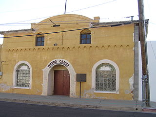
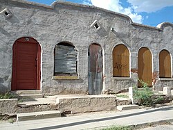
The Teatro Carmen was Tucson's first Spanish-language theater. From 1915 until it closed in the 1920s, it was the foremost theater for Spanish-language productions and a community center for Tucson's Mexican community. It is in the Barrio Viejo neighborhood.