Barry Buddon Training Area

Last updated

Barry Buddon
Barry, Angus
Barry Buddon camp - geograph.org.uk - 13865.jpg
Barry Buddon Camp
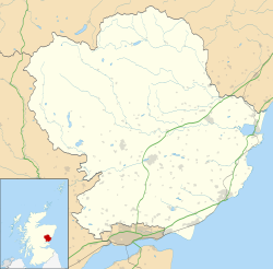
Angus UK location map.svg
Red pog.svg
Barry Buddon
Location within Angus
Coordinates 56°28′50″N2°45′15″W / 56.48056°N 2.75417°W / 56.48056; -2.75417 Coordinates: 56°28′50″N2°45′15″W / 56.48056°N 2.75417°W / 56.48056; -2.75417
TypeBarracks
Site information
Owner Ministry of Defence
OperatorFlag of the British Army.svg  British Army
Site history
Builtc.1850
Built for War Office
In usec.1850 – present

Barry Buddon Training Area is a Ministry of Defence-owned rifle range and training area in Barry, Angus, Scotland, which runs adjacent to Carnoustie Golf Links and the Dundee - Aberdeen railway Line.
Contents

History

Barry Buddon dates back to around 1850 when the area was used by the Forfarshire Rifle Volunteers, the Fife and Forfar Yeomanry, the Panmure Battery of the Forfarshire Artillery Brigade, and a Royal Naval Reserve Battery. In 1897 the Earl of Dalhousie sold the site to the War Office for use as a military training area. [1]

The training area covers 2,300 acres (930 hectares), of which 600 acres (240 hectares) is intertidal zone. The camp was expanded in the late 1990s and has accommodation for 507. [1] With all camps and facilities at maximum usage about 130,000 personnel could use the training area each year. [1] The ranges were used in the 1986 Commonwealth Games and the 2014 Commonwealth Games. [2]

Engine shed of the narrow gauge railway on the Barry Buddon range Engine shed on Barry Buddon range (geograph 2171571).jpg
Engine shed of the narrow gauge railway on the Barry Buddon range

The Barry Buddon range used a narrow gauge railway with an armoured diesel locomotive to pull moving targets on railway wagons to be used for gunnery practise. [3]

Most of the training area is a Site of Special Scientific Interest (SSSI) and an EU Special Area of Conservation (SAC), as well as a Special Protection Area (SPA) for birds under the European Birds Directive. [4]

See also

Related Research Articles

Angus, Scotland Council area of Scotland

Angus is one of the 32 local government council areas of Scotland, a registration county and a lieutenancy area. The council area borders Aberdeenshire, Dundee City and Perth and Kinross. Main industries include agriculture and fishing. Global pharmaceuticals company GSK has a significant presence in Montrose in the north of the county.

Cape Wrath

Cape Wrath is a cape in the Durness parish of the county of Sutherland in the Highlands of Scotland. It is the most north-westerly point in mainland Britain.

Carnoustie Human settlement in Scotland

Carnoustie is a town and former police burgh in the council area of Angus, Scotland. It is at the mouth of the Barry Burn on the North Sea coast. In the 2011 census, Carnoustie had a population of 11,394, making it the fourth largest town in Angus.

RAF Wainfleet

RAF Wainfleet was a Royal Air Force weapons range on The Wash on the east coast of England near Wainfleet, in the civil parish of Friskney, although the north-east part of the range was in Wainfleet St Mary. Other ranges nearby include RAF Holbeach, also on The Wash, and RAF Donna Nook. It was also known as The Wash Bombing Range. It was only a few miles south-west of Gibraltar Point.

Point Nepean

Point Nepean marks the southern point of The Rip and the most westerly point of the Mornington Peninsula, in Victoria, Australia. It was named in 1802 after the British politician and colonial administrator Sir Evan Nepean by John Murray in HMS Lady Nelson. Its coast and adjacent waters are included in the Port Phillip Heads Marine National Park, while its land area is part of the Point Nepean National Park. The point includes Cheviot Beach on its southern side, famous as the site of the disappearance of Australia's then-Prime Minister Harold Holt.

Monifieth Human settlement in Scotland

Monifieth is a town and former police burgh in the council area of Angus, Scotland. It is situated on the north bank of the Firth of Tay on the east coast. In 2016, the population of Monifieth was estimated at 8,110, making it the fifth largest town in Angus.

Puckapunyal Town in Victoria, Australia

Puckapunyal is an Australian Army training facility and base 10 km west of Seymour, in central Victoria, south-eastern Australia.

Barry, Angus Small village in Angus, Scotland, on Barry Burn at the mouth of the River Tay

Barry is a small village in Angus, Scotland, on Barry Burn at the mouth of the River Tay. The recent completion of a bypass for the village on the A930 road from Dundee to Carnoustie is something that was originally planned before the Second World War. There is a water mill operated by the National Trust for Scotland. The village is served by Barry Links railway station. The village was formerly served by Barry primary school which closed in 2007.

Daisy Hill, Queensland Suburb of Logan City, Queensland, Australia

Daisy Hill is a suburb of Logan City, Queensland, Australia. Part of the suburb's western boundary follows the Pacific Motorway. A large proportion of the Daisy Hill is protected by the Daisy Hill Conservation Park.

ANZAC Rifle Range

The ANZAC Rifle Range is a rifle range located on the Malabar Headland, Malabar, in the City of Randwick local government area of New South Wales, Australia. It is headquarters to the New South Wales Rifle Association, and hosts the annual NSW Queen's Prize shooting competitions. The range is located on land owned by the Commonwealth of Australia.

Belmont, Queensland Suburb of Brisbane, Queensland, Australia

Belmont is an outer suburb of the City of Brisbane, Queensland, Australia. It is 12 kilometres (7.5 mi) south-east of the Brisbane CBD. In the 2016 census Belmont has a population of 4,374 people.

Malabar Headland

The Malabar Headland is a heritage-listed former public recreation area and military installation site and now nature conservation and public recreation headland area located at Franklin Street, Malabar in the City of Randwick local government area of New South Wales, Australia. It is also known as Long Bay Rifle Range, Anzac Rifle Range and Boora Point. The property is owned by the New South Wales Government. It was added to the New South Wales State Heritage Register on 22 July 2005.

Munster Training Area

Munster Training Area is a military training area in Germany on the Lüneburg Heath. It comprises two separate areas with different purposes: Munster North (Munster-Nord) and Munster South (Munster-Süd). The two areas are separated geographically by the town of Munster and several barracks. When the military training area was established a camp or Lager was built about 1.5 kilometres from the town centre which became known as Munsterlager. Between Munster North and South there is a road corridor to the nearby training area of Bergen-Hohne over which exercising troops can transfer from one area to the other. There are many rare and endangered plant species on this terrain today that thrive in the environment created by the training area.

Dartmoor Training Area

The Dartmoor Training Area (DTA) is a military training area on Dartmoor in Devon in southwest England. The area consists of approximately 13,000 hectares in the Dartmoor National Park.

Penhale Sands

Penhale Sands, or Penhale Dunes, is a complex of sand dunes and a protected area for its wildlife, on the north Cornwall coast in England, UK. It is the most extensive system of sand dunes in Cornwall and is believed to be the landing site of Saint Piran. Dating from the 6th century, St Piran's Oratory is thought to be one of the oldest Christian sites in Britain. The remains were discovered in the late 18th century, and in 2014 the covering sand was removed to reveal a building more than a thousand years old, in a reasonable state of preservation. A restricted military area dating from 1939, Penhale Camp, is found on the northern part of the dunes.

This article lists the Venues of the 2014 Commonwealth Games.

Defence Training Estates is an organisation within the United Kingdom Ministry of Defence. It is the operating division of the Defence Infrastructure Organisation, and is responsible for the management of the 78% of the defence estate allocated as Training Areas and Ranges. It provides sufficient and suitable estate to support the training requirements of the British Armed Forces, whilst ensuring environmental management and appropriate historical and archaeological preservation.

Irwin Barracks

Irwin Barracks is an Australian Army military base located in Karrakatta, a suburb of Perth, Western Australia. It occupies a 62-hectare (150-acre) site on the western side of the Fremantle railway line.

Garelochhead Training Camp

Garelochhead Training Camp is a military training camp located near Garelochhead in Scotland.

Buddon railway station served the Barry Buddon Training Area from 1910 to 1914 on the Dundee and Arbroath Railway.

References

  1. 1 2 3 "Barry Buddon Training Area" (PDF). Defence Training Estate Scotland. Retrieved 13 April 2014.
  2. "Barry Buddon on target". Glasgow XX Commonwealth Games. Retrieved 13 April 2014.
  3. "Barry Buddon Training Centre Ranges". Secret Scotland. Retrieved 4 March 2017.
  4. "Shoreline management Plan - Coastal Process Unit 8" (PDF). Angus Council. Archived from the original (PDF) on 13 April 2014. Retrieved 13 April 2014.