
Kirkham is a village in the civil parish of Westow, in North Yorkshire, England, close to Malton, situated in the Howardian Hills alongside the River Derwent, and is notable for the nearby ruins of Kirkham Priory, an Augustinian establishment.

Barton-le-Willows is a village and civil parish in North Yorkshire, England, situated near the River Derwent, about eight miles south-west of Malton. The parish had a population of 186 according to the 2001 census increasing to 284 at the 2011 Census. The village is recorded as Bartun in the Domesday Book.

Moulton End is a hamlet in North Yorkshire, in England.

Redmire is a village and civil parish in North Yorkshire, England. It is about 4 miles (6.4 km) west of Leyburn in Wensleydale in the Yorkshire Dales.

Speeton is a village in the civil parish of Reighton, in North Yorkshire, England. It lies near the edge of the coastal cliffs midway between Filey and Bridlington. It is North Yorkshire's easternmost settlement, but historically lay in the East Riding of Yorkshire until local government re-organisation in 1974. It was part of the Borough of Scarborough from 1974 until 2023.

Dalton Gates is a hamlet in the Richmondshire district of North Yorkshire, England.

Newton-le-Willows is a village and civil parish in the Richmondshire district of North Yorkshire, England, 3 miles (4.8 km) west of Bedale. Historically, it is part of the North Riding of Yorkshire and the Wapentake of Hang East.
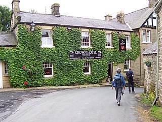
Lofthouse is a small village in Nidderdale in the Harrogate district of North Yorkshire, England about a mile south of Middlesmoor. It is the principal settlement in the civil parish of Fountains Earth. Lofthouse has a primary school, memorial village hall and public house, the Crown Hotel. The post office in the village closed in August 2014, and was replaced by a post office in the cafe at nearby How Stean Gorge, also now closed.

Hopperton is a village in the Harrogate district of North Yorkshire, England. It is part of the Allerton Mauleverer with Hopperton parish. The village is situated close to the A59, the A1(M) and the A168. Cattal railway station is situated just under two miles from the village with services to Leeds, York and Harrogate. Until 1958, Hopperton had its own railway station next to a level crossing on the original A1 Great North Road. The village has one pub, the Mason Arms, and a bed and breakfast. The nearest towns are Knaresborough 4 miles (6.4 km) to the west, and across the county border in West Yorkshire, Wetherby 5 miles (8 km) to the south west. The latter offers the closest large supermarket to Hopperton.

Thornborough is a village in Hambleton District of North Yorkshire, England. It is about 7 miles (11 km) south of Bedale and 3 miles (5 km) west of the A1(M) motorway. Thornborough is in the West Tanfield parish. The Thornborough Henges ancient monuments are situated south and west of the village. The village lies just to the south of the B6267 road, which connects the A6055 in the east, with the A6108 road at Masham. The village is served by two buses a day in each direction between Ripon and Masham. When the Masham Branch of the North Eastern Railway was open, Tanfield station would have been the nearest railway station to Thornborough. Now the nearest railway station is at Thirsk.
Nidd is a small village and civil parish in the Harrogate district of North Yorkshire, England. The population of the village taken at the 2011 census was 168. It is situated 3 miles north of Harrogate, 1.2 miles (2 km) east of Ripley on the B6165 Pateley Bridge to Knaresborough road and near the River Nidd. The village used to have a railway station on the Leeds to Northallerton Railway, but this was closed down on 18 June 1962.

Rillington is a village and civil parish in North Yorkshire, England.
Battersby is a hamlet in North Yorkshire, England. It lies on the edge of the North York Moors National Park and within the historic boundaries of the North Riding of Yorkshire, 5 miles (8 km) east of Stokesley, and 1.5 miles (2.4 km) south-west of Kildale. The settlement is mentioned in the Domesday Book as being part of the hundred of Langbaurgh, and having one ploughland. The name is recorded in 1086 as Badresbi, and in the 14th century as Batheresby. The first part is an Old Norse name, and the by means farmstead. In the Late Middle Ages a watermill was employed on the local beck to grind corn.

Bouthwaite is a hamlet in the Harrogate district of North Yorkshire, England. It is situated in Nidderdale, to the north of Pateley Bridge, close to the village of Ramsgill. The Nidderdale Way and Six Dales Trail both pass through the hamlet.

Gristhorpe is a village and civil parish in the Scarborough district of North Yorkshire, England. According to the 2011 UK census, Gristhorpe parish had a population of 397, an increase on the 2001 UK census figure of 386.

West Knapton is a small village in the civil parish of Scampston, in North Yorkshire, England. It is situated on the edge of the Yorkshire Wolds at the foot of the North York Moors. The village is accessed by the A64.

North Grimston is a village in the civil parish of Birdsall, in North Yorkshire, England. It is situated between Norton-on-Derwent and Wharram-le-Street on the B1248 road. In 1931 the parish had a population of 143. On 1 April 1935 the parish was abolished and merged with Birdsall.

Staintondale is a small village and civil parish in the Scarborough district of North Yorkshire, England. The village is situated 7 miles (11 km) north west of Scarborough town centre. The parish also includes the village of Ravenscar, 2 miles (3 km) north of the village of Staintondale, and the whole parish lies within the North York Moors National Park.
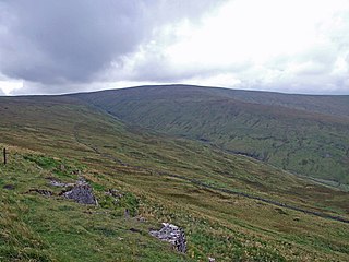
Dodd Fell Hill is a hill in the Yorkshire Dales, in North Yorkshire, England. It is classed as a Marilyn.

Butterwick is a village and former civil parish about 6 miles from Pickering, now in the parish of Barton-le-Street, in North Yorkshire, England. In 1961 the parish had a population of 41. Butterwick has a church called Holy Epiphany.


