Related Research Articles

Hydrology is the scientific study of the movement, distribution, and management of water on Earth and other planets, including the water cycle, water resources, and environmental watershed sustainability. A practitioner of hydrology is called a hydrologist. Hydrologists are scientists studying earth or environmental science, civil or environmental engineering, and physical geography. Using various analytical methods and scientific techniques, they collect and analyze data to help solve water related problems such as environmental preservation, natural disasters, and water management.

A hydrograph is a graph showing the rate of flow (discharge) versus time past a specific point in a river, channel, or conduit carrying flow. The rate of flow is typically expressed in cubic meters or cubic feet per second . It can also refer to a graph showing the volume of water reaching a particular outfall, or location in a sewerage network. Graphs are commonly used in the design of sewerage, more specifically, the design of surface water sewerage systems and combined sewers.
In hydrology, discharge is the volumetric flow rate of water that is transported through a given cross-sectional area. It includes any suspended solids, dissolved chemicals, or biologic material in addition to the water itself. Terms may vary between disciplines. For example, a fluvial hydrologist studying natural river systems may define discharge as streamflow, whereas an engineer operating a reservoir system may equate it with outflow, contrasted with inflow.
In water-related science and engineering, there are two similar but distinct definitions in use for the word drawdown:
Ecohydrology is an interdisciplinary scientific field studying the interactions between water and ecological systems. It is considered a sub discipline of hydrology, with an ecological focus. These interactions may take place within water bodies, such as rivers and lakes, or on land, in forests, deserts, and other terrestrial ecosystems. Areas of research in ecohydrology include transpiration and plant water use, adaption of organisms to their water environment, influence of vegetation and benthic plants on stream flow and function, and feedbacks between ecological processes and the hydrological cycle.
Isotope hydrology is a field of geochemistry and hydrology that uses naturally occurring stable and radioactive isotopic techniques to evaluate the age and origins of surface and groundwater and the processes within the atmospheric hydrologic cycle. Isotope hydrology applications are highly diverse, and used for informing water-use policy, mapping aquifers, conserving water supplies, assessing sources of water pollution, and increasingly are used in eco-hydrology to study human impacts on all dimensions of the hydrological cycle and ecosystem services.
Drainage density is a quantity used to describe physical parameters of a drainage basin. First described by Robert E. Horton, drainage density is defined as the total length of channel in a drainage basin divided by the total area, represented by the following equation:
The United States Environmental Protection Agency (EPA) Storm Water Management Model is a dynamic rainfall–runoff–subsurface runoff simulation model used for single-event to long-term (continuous) simulation of the surface/subsurface hydrology quantity and quality from primarily urban/suburban areas. It can simulate the Rainfall- runoff, runoff, evaporation, infiltration and groundwater connection for roots, streets, grassed areas, rain gardens and ditches and pipes, for example. The hydrology component of SWMM operates on a collection of subcatchment areas divided into impervious and pervious areas with and without depression storage to predict runoff and pollutant loads from precipitation, evaporation and infiltration losses from each of the subcatchment. Besides, low impact development (LID) and best management practice areas on the subcatchment can be modeled to reduce the impervious and pervious runoff. The routing or hydraulics section of SWMM transports this water and possible associated water quality constituents through a system of closed pipes, open channels, storage/treatment devices, ponds, storages, pumps, orifices, weirs, outlets, outfalls and other regulators. SWMM tracks the quantity and quality of the flow generated within each subcatchment, and the flow rate, flow depth, and quality of water in each pipe and channel during a simulation period composed of multiple fixed or variable time steps. The water quality constituents such as water quality constituents can be simulated from buildup on the subcatchments through washoff to a hydraulic network with optional first order decay and linked pollutant removal, best management practice and low-impact development removal and treatment can be simulated at selected storage nodes. SWMM is one of the hydrology transport models which the EPA and other agencies have applied widely throughout North America and through consultants and universities throughout the world. The latest update notes and new features can be found on the EPA website in the download section. Recently added in November 2015 were the EPA SWMM 5.1 Hydrology Manual and in 2016 the EPA SWMM 5.1 Hydraulic Manual and EPA SWMM 5.1 Water Quality Volume (III) + Errata”
Streamflow, or channel runoff, is the flow of water in streams, rivers, and other channels, and is a major element of the water cycle. It is one component of the runoff of water from the land to waterbodies, the other component being surface runoff. Water flowing in channels comes from surface runoff from adjacent hillslopes, from groundwater flow out of the ground, and from water discharged from pipes. The discharge of water flowing in a channel is measured using stream gauges or can be estimated by the Manning equation. The record of flow over time is called a hydrograph. Flooding occurs when the volume of water exceeds the capacity of the channel.
Baseflow is the portion of the streamflow that is sustained between precipitation events, fed to streams by delayed pathways. It should not be confused with groundwater flow. Fair weather flow is also called base flow.

An hydrological transport model is a mathematical model used to simulate the flow of rivers, streams, groundwater movement or drainage front displacement, and calculate water quality parameters. These models generally came into use in the 1960s and 1970s when demand for numerical forecasting of water quality and drainage was driven by environmental legislation, and at a similar time widespread access to significant computer power became available. Much of the original model development took place in the United States and United Kingdom, but today these models are refined and used worldwide.
A runoff model is a mathematical model describing the rainfall–runoff relations of a rainfall catchment area, drainage basin or watershed. More precisely, it produces a surface runoff hydrograph in response to a rainfall event, represented by and input as a hyetograph. In other words, the model calculates the conversion of rainfall into runoff.
A well known runoff model is the linear reservoir, but in practice it has limited applicability.
The runoff model with a non-linear reservoir is more universally applicable, but still it holds only for catchments whose surface area is limited by the condition that the rainfall can be considered more or less uniformly distributed over the area. The maximum size of the watershed then depends on the rainfall characteristics of the region. When the study area is too large, it can be divided into sub-catchments and the various runoff hydrographs may be combined using flood routing techniques.
SMS is a complete program for building and simulating surface water models from Aquaveo. It features 1D and 2D modeling and a unique conceptual model approach. Currently supported models include ADCIRC, CMS-FLOW2D, FESWMS, TABS, TUFLOW, BOUSS-2D, CGWAVE, STWAVE, CMS-WAVE (WABED), GENESIS, PTM, and WAM.

A hydrologic model is a simplification of a real-world system that aids in understanding, predicting, and managing water resources. Both the flow and quality of water are commonly studied using hydrologic models.
GSSHA is a two-dimensional, physically based watershed model developed by the Engineer Research and Development Center of the United States Army Corps of Engineers. It simulates surface water and groundwater hydrology, erosion and sediment transport. The GSSHA model is used for hydraulic engineering and research, and is on the Federal Emergency Management Agency (FEMA) list of hydrologic models accepted for use in the national flood insurance program for flood hydrograph estimation. Input is best prepared by the Watershed Modeling System interface, which effectively links the model with geographic information systems (GIS).
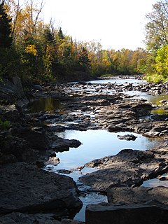
The Knife River is a 23.9-mile-long (38.5 km) river of northern Minnesota which drains a portion of Lake and Saint Louis counties into Lake Superior between Duluth and Two Harbors.
An alluvial river is one in which the bed and banks are made up of mobile sediment and/or soil. Alluvial rivers are self-formed, meaning that their channels are shaped by the magnitude and frequency of the floods that they experience, and the ability of these floods to erode, deposit, and transport sediment. For this reason, alluvial rivers can assume a number of forms based on the properties of their banks; the flows they experience; the local riparian ecology; and the amount, size, and type of sediment that they carry.
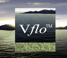
Vflo is a commercially available, physics-based distributed hydrologic model generated by Vieux & Associates, Inc. Vflo uses radar rainfall data for hydrologic input to simulate distributed runoff. Vflo employs GIS maps for parameterization via a desktop interface. The model is suited for distributed hydrologic forecasting in post-analysis and in continuous operations. Vflo output is in the form of hydrographs at selected drainage network grids, as well as distributed runoff maps covering the watershed. Model applications include civil infrastructure operations and maintenance, stormwater prediction and emergency management, continuous and short-term surface water runoff, recharge estimation, soil moisture monitoring, land use planning, water quality monitoring, and water resources management.
In hydrology, routing is a technique used to predict the changes in shape of a hydrograph as water moves through a river channel or a reservoir. In flood forecasting, hydrologists may want to know how a short burst of intense rain in an area upstream of a city will change as it reaches the city. Routing can be used to determine whether the pulse of rain reaches the city as a deluge or a trickle.
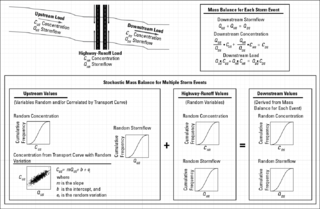
The stochastic empirical loading and dilution model (SELDM) is a stormwater quality model. SELDM is designed to transform complex scientific data into meaningful information about the risk of adverse effects of runoff on receiving waters, the potential need for mitigation measures, and the potential effectiveness of such management measures for reducing these risks. The U.S. Geological Survey developed SELDM in cooperation with the Federal Highway Administration to help develop planning-level estimates of event mean concentrations, flows, and loads in stormwater from a site of interest and from an upstream basin. SELDM uses information about a highway site, the associated receiving-water basin, precipitation events, stormflow, water quality, and the performance of mitigation measures to produce a stochastic population of runoff-quality variables. Although SELDM is, nominally, a highway runoff model is can be used to estimate flows concentrations and loads of runoff-quality constituents from other land use areas as well. SELDM was developed by the U.S. Geological Survey so the model, source code, and all related documentation are provided free of any copyright restrictions according to U.S. copyright laws and the USGS Software User Rights Notice. SELDM is widely used to assess the potential effect of runoff from highways, bridges, and developed areas on receiving-water quality with and without the use of mitigation measures. Stormwater practitioners evaluating highway runoff commonly use data from the Highway Runoff Database (HRDB) with SELDM to assess the risks for adverse effects of runoff on receiving waters.
References
- 1 2 Vitvar et al., 2002. Estimation of baseflow residence times in watersheds from the runoff hydrograph recession: method and application in the Neversink watershed, Catskill Mountains, New York. Hydrol. Processes16 1871-1877 Archived 2016-03-03 at the Wayback Machine
- ↑ Brutsaert and Nieber, 1977. Regionalized Drought Flow Hydrographs from a Mature Glaciated Plateau. Water Resources Research. Vol. 13, No. 11