The Basilica of Sacré Coeur de Montmartre, commonly known as Sacré-Cœur Basilica and often simply Sacré-Cœur, is a Roman Catholic church and minor basilica in Paris dedicated to the Sacred Heart of Jesus. It was formally approved as a national historic monument by the National Commission of Patrimony and Architecture on December 8, 2022.
Justiniana Prima was an Eastern Roman city that existed from 535 to 615, and currently an archaeological site, known as or Caričin Grad, near modern Lebane in the Leskovac region, southern Serbia. It was founded by Emperor Justinian I (527-565) and served as the metropolitan seat of the then newly founded Archbishopric of Justiniana Prima, which became the main church administrative body of the central and western Balkans with jurisdiction from Praevalitana to Dacia Ripensis. Justinian Prima was originally designed to become the capital of the prefecture of Illyricum, but for reasons likely related with its status near the Roman frontiers of the 6th century CE, Thessaloniki was preferred. It was abandoned less than 100 years after its foundation.

Djémila, formerly Cuicul, is a small mountain village in Algeria, near the northern coast east of Algiers, where some of the best preserved Roman ruins in North Africa are found. It is situated in the region bordering the Constantinois and Petite Kabylie.

Maktar or Makthar, also known by other names during antiquity, is a town and archaeological site in Siliana Governorate, Tunisia.
Tipasa, sometimes distinguished as Tipasa in Mauretania, was a colonia in the Roman province Mauretania Caesariensis, nowadays called Tipaza, and located in coastal central Algeria. Since 1982, it has been declared by UNESCO a World Heritage Site. It was declared a World Heritage Site in danger in 2002, but was removed from the danger list in 2006 following conservation efforts.

Thelepte was a city in the Roman province of Byzacena, now in western Tunisia. It is located near the border with Algeria about 5 km north from the modern town of Fériana and 30 km south-west of the provincial capital Kasserine.

Haïdra is a municipality in western Tunisia, containing the ruins of Ammaedara, one of the oldest Roman cities in Africa. It was a diocese and is now a Roman Catholic titular see.

Uppenna or Upenna is a Tunisian archaeological site located on the site of the present locality of Henchir Chigarnia. The site has delivered a basilica and the remains of a fortress.

Carthage National Museum is a national museum in Byrsa, Tunisia. Along with the Bardo National Museum, it is one of the two main local archaeological museums in the region. The edifice sits atop Byrsa Hill, in the heart of the city of Carthage. Founded in 1875, it houses many archaeological items from the Punic era and other periods.

El Alia is a town and commune in the Bizerte Governorate, Tunisia.

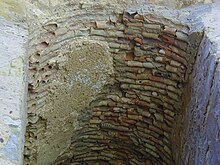
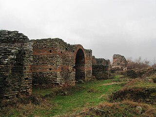
The "Red Basilica", also called variously the Red Hall and Red Courtyard, is a monumental ruined temple in the ancient city of Pergamon, now Bergama, in western Turkey. The temple was built during the Roman Empire, probably in the time of Hadrian and possibly on his orders. It is one of the largest Roman structures still surviving in the ancient Greek world. The temple is thought to have been used for the worship of Egyptian gods – specifically Isis and/or Serapis, and possibly also Osiris, Harpocrates and other lesser gods, who may have been worshipped in a pair of drum-shaped rotundas, both of which are virtually intact, alongside the main temple.

Pupput, also spelled "Putput", "Pudput", "Pulpud" and "Pulpite" in Latin, sometimes located in Souk el-Obiod ou Souk el-Abiod, is a Colonia in the Roman province of Africa which has been equated with an archaeological site in modern Tunisia. It is situated on the coast near the town of Hammamet, between the two wadis of Temad to the north and Moussa to the south. Much of the Pupput is buried under modern holiday developments which have been built over the major part of the site.
Noël Duval was a French archaeologist.
The Archdiocese of Carthage, also known as the Church of Carthage, was a Latin Catholic diocese established in Carthage, Roman Empire, in the 2nd century. Agrippin was the first named bishop, around 230 AD. The temporal importance of the city of Carthage in the Roman Empire had previously been restored by Julius Caesar and Augustus. When Christianity became firmly established around the Roman province of Africa Proconsulare, Carthage became its natural ecclesiastical seat. Carthage subsequently exercised informal primacy as an archdiocese, being the most important center of Christianity in the whole of Roman Africa, corresponding to most of today's Mediterranean coast and inland of Northern Africa. As such, it enjoyed honorary title of patriarch as well as primate of Africa: Pope Leo I confirmed the primacy of the bishop of Carthage in 446: "Indeed, after the Roman Bishop, the leading Bishop and metropolitan for all Africa is the Bishop of Carthage."
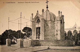
The Chapelle Saint-Louis de Carthage was a Roman Catholic church located in Carthage, Tunisia. It was built between 1840 and 1841 on land donated by the Bey of Tunis to the King of France in 1830. The chapel was located atop Byrsa Hill, at the heart of the Archaeological Site of Carthage, until it was destroyed in 1950.

Sétifis, was a Romano town located in northeastern Algeria. It was the capital of the Roman province called Mauretania Sitifensis, and it is today Setif in the Sétif Province (Algeria).
Baia was an ancient city and bishopric in the Roman province of Africa Proconsulare. It is a Roman Catholic titular see.
Naïdé Ferchiou was a Tunisian archaeologist whose work dealt mainly with Roman North Africa. She excavated at several important sites, including Abthugni.

The Fountain with a Thousand Amphorae is an archaeological site located in the city of Carthage in Tunisia.
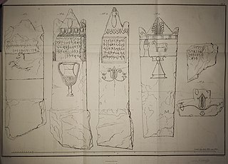
Carthaginian tombstones are Punic language-inscribed tombstones excavated from the city of Carthage over the last 200 years. The first such discoveries were published by Jean Emile Humbert in 1817, Hendrik Arent Hamaker in 1828 and Christian Tuxen Falbe in 1833.