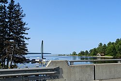
The Michipicoten River is a river in Algoma District of northern Ontario, Canada, which flows from Dog Lake and joins with the Magpie River to empty into Michipicoten Bay on Lake Superior near the town of Wawa. This river is 113 km (70 mi) in length and drains an area of about 5,200 km2 (2,000 sq mi).

The Agawa River is a river in Algoma District, Ontario, Canada which empties into Agawa Bay on Lake Superior at the community of Agawa Bay, south of Wawa, Ontario.

Lake Superior Provincial Park is one of the largest provincial parks in Ontario, covering about 1,550 square kilometres (600 sq mi) along the northeastern shores of Lake Superior between Sault Ste. Marie and Wawa in Algoma District in Northwestern Ontario, Canada. Ontario Highway 17 now runs through the park. When the park was established by Ontario in 1944, there was no road access.

The Mississagi River is a river in Algoma and Sudbury Districts, Ontario, Canada, that originates in Sudbury District and flows 266 kilometres (165 mi) to Lake Huron at Blind River, Algoma District.

The Black Sturgeon River is a river in Thunder Bay District, Northwestern Ontario, Canada, located west of the Nipigon River, that flows to Lake Superior.
The Brightsand River is a river in the James Bay drainage basin in Unorganized Thunder Bay District in northwestern Ontario, Canada.
The Magpie River is a river in Algoma District, northeastern Ontario, Canada, The river empties into Michipicoten Bay on Lake Superior near the town of Wawa. The river drains an area of about 1,900 square kilometres (734 sq mi).
The Pukaskwa River is a river in Thunder Bay District and Algoma District in Northern Ontario, Canada. It is in the Great Lakes Basin and is a tributary of Lake Superior, which it enters at the south end of Pukaskwa National Park. It is a remote, pristine, free-flowing, medium-sized Shield river, with lots of whitewater, best travelled in spring.

The North Shore of Lake Superior runs from Duluth, Minnesota, United States, at the southwestern end of the lake, to Thunder Bay and Nipigon, Ontario, Canada, in the north to Sault Ste. Marie, Ontario, in the east. The shore is characterized by alternating rocky cliffs and cobblestone beaches, with forested hills and ridges through which scenic rivers and waterfalls descend as they flow to Lake Superior.
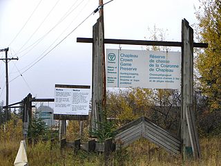
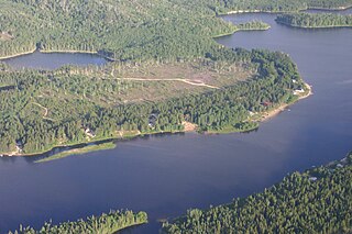
The Chapleau Crown Game Preserve is a fur bearing animal preserve area in Ontario, Canada, north-east of Lake Superior. It covers some 7,000 square kilometres (2,700 sq mi) in the Algoma and Sudbury Districts, and is officially classified as a Crown Game Preserve by the Government of Ontario Ministry of Natural Resources.

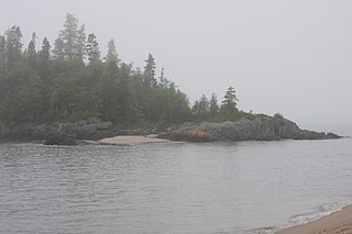
Batchawana Bay is a small bay in Algoma District in Northeastern Ontario, Canada. It is on the eastern shore of Lake Superior, approximately 50 kilometres (31 mi) north of Sault Ste. Marie.

Rankin Location 15D is one of four reserves of the Batchewana First Nation of Ojibways in Algoma District in northeastern Ontario, Canada. It is bounded on the north, west and south by the city of Sault Ste. Marie, and on the east by Garden River First Nations reserve of another Ojibwe people. As of 2005, a total of 2,205 people were registered to the Nation; about half live on the reserves and many others live in Sault Ste. Marie.
Batchawana Bay is an unincorporated place and Compact Rural Community in Algoma District in Northeastern Ontario, Canada. It is also the name of a local services board, consisting of parts of the geographic townships of Fisher, Herrick, Ryan and Tilley. It is located north of Sault Ste. Marie, Ontario, on the shores of Batchawana Bay off Lake Superior.

The Groundhog River is a river in Cochrane District and Sudbury District in Northeastern Ontario, Canada. The river is in the James Bay drainage basin and is a left tributary of the Mattagami River.
The Carp River is a river in the Unorganized North Part of Algoma District in Northeastern Ontario, Canada. The river is in the Great Lakes Basin and is a tributary of Lake Superior.
The Matawin River is a river in Thunder Bay District in Northwestern Ontario, Canada. It is in the Great Lakes Basin and is a right tributary of the Kaministiquia River.
The Batchewana First Nation of Ojibways is an Ojibway First Nation in northern Ontario. Their traditional lands run along the eastern shore of Lake Superior, from Batchawana Bay to Whitefish Island. They were reserved this land in the 1850 Robinson Huron Treaty, but surrendered most of it under the 1859 Pennefather Treaty. Through purchase and land claims, it has reclaimed some territories, including Goulais Bay 15A, Obadjiwan 15E, Rankin Location 15D and Whitefish Island.
The Chapleau River is a river in Algoma District and Sudbury District in northeastern Ontario, Canada. It is in the James Bay drainage basin, begins at Chapleau Lake and is the main tributary of Kapuskasing Lake.

La Cloche Provincial Park is a provincial park at the boundary of Algoma and Sudbury Districts in Ontario, Canada. The park consists of an unspoiled section of the La Cloche Mountains that stretch along the North Channel of Georgian Bay, as well as several islands in the channel.
Michipicoten Provincial Park is a park in Ontario, Canada, located at the mouth of the Michipicoten River. The park preserves the ruins of a French trading post that operated from the early 1700s until it was abandoned by the Hudson’s Bay Company in 1904.