Bath, New York

Last updated

Bath
BathNYovervlook.jpg
A view of Bath
USA New York location map.svg
Red pog.svg
Bath
Location of Bath in New York
Coordinates: 42°20′13″N77°19′05″W / 42.33694°N 77.31806°W / 42.33694; -77.31806
CountryUnited States
State New York
County Steuben
Area
[1]
  Total95.88 sq mi (248.32 km2)
  Land95.32 sq mi (246.89 km2)
  Water0.56 sq mi (1.44 km2)  0.3%
Population
 (2020)
  Total11,426 Decrease2.svg
  Estimate 
(2021) [2]
11,334
  Density126.49/sq mi (48.84/km2)
Time zone UTC+5 (EST)
  Summer (DST) UTC+4 (EDT)
ZIP code
14810
Area code 607
FIPS code 36-101-04770
Website www.townofbathny.org

Bath is a town in Steuben County, New York, United States, with an area of 96.3 square miles (249 km2) and a population of 11,426 in 2020. [2] Its largest settlement is the Village of Bath, which has an area of 2.9 sq mi (7.5 km2) and a population of 5,641 (in 2000). The Village is the county seat of Steuben County. The Town is located in the central part of the county, northwest of Elmira. The town and village are either named after the city of Bath in England or after Lady Bath, daughter of a landowner.

Contents

History

Bath Soldiers Monument Soldiers Monument, Bath, N.Y. 1909.jpg
Bath Soldiers Monument

The town was founded in 1793 and was part of a land investment by wealthy Briton William Pulteney, and named after Bath, Somerset in England, where he owned extensive estates. It was created along with Steuben County in 1796 and became a mother town of the county, eventually yielding land to seven later towns. The Lackawanna Railroad opened its mainline through Bath, and opened a station, in 1882. [3]

The first jailhouse was built in 1796 which was constructed out of logs at a location just west of Pulteney Square. It was eventually replaced by a more durable structure made of stone. [4]

In 1828 a brick court-house was constructed which was destroyed by fire. Using the same plan, It was immediately replaced using the same foundation. [4]

Business stationary of The Globe Clothiers, Hatters & Furnishings, Bath, NY, 1891. Reverse of postal covers depicts the business and municipal statistics of Bath in the late 19th century THE GLOBE, CLOTHIERS,HATTERS, Bath, NY, 1891.jpg
Business stationary of The Globe Clothiers, Hatters & Furnishings, Bath, NY, 1891. Reverse of postal covers depicts the business and municipal statistics of Bath in the late 19th century

Geography

The United States Census Bureau lists the town's total area as 96.3 square miles (249.4 km2), of which 96.0 square miles (248.6 km2) is land and 0.3 square mile (0.8 km2)(0.32%) is water.

Interstate 86 (Southern Tier Expressway) passes through the town. New York State Route 54 and New York State Route 415 intersect in Bath village. New York State Route 53 has its southern terminus at NY-415 in the community of Kanona. New York State Route 226 passes through Savona.

The Cohocton River flows through the town past the hamlet of Kanona and the villages of Bath and Savona.

Communities and locations in the town of Bath

Climate

This climatic region is typified by large seasonal temperature differences, with warm to hot (and often humid) summers and cold (sometimes severely cold) winters. According to the Köppen Climate Classification system, Bath has a humid continental climate, abbreviated "Dfb" on climate maps. [5]

Demographics

Historical population
CensusPop.Note
1820 2,578
1830 3,38731.4%
1840 4,91545.1%
1850 6,18525.8%
1860 5,129−17.1%
1870 6,23621.6%
1880 7,39618.6%
1890 7,8816.6%
1900 8,4377.1%
1910 8,5541.4%
1920 7,317−14.5%
1930 7,8437.2%
1940 9,35419.3%
1950 10,92616.8%
1960 11,9789.6%
1970 11,953−0.2%
1980 12,2682.6%
1990 12,7243.7%
2000 12,097−4.9%
2010 12,3792.3%
2020 11,426−7.7%
2021 (est.)11,334 [2] −0.8%
U.S. Decennial Census [6]

As of the census [7] of 2000, there were 12,097 people, 4,905 households, and 3,050 families residing in the town. The population density was 126.0 inhabitants per square mile (48.6/km2). There were 5,402 housing units at an average density of 56.3 per square mile (21.7/km2). The racial makeup of the town was 96.04% White, 1.79% Black or African American, 0.30% Native American, 0.71% Asian, 0.03% Pacific Islander, 0.10% from other races, and 1.03% from two or more races. Hispanic or Latino of any race were 0.70% of the population.

There were 4,905 households, out of which 28.5% had children under the age of 18 living with them, 45.5% were married couples living together, 11.9% had a female householder with no husband present, and 37.8% were non-families. 31.6% of all households were made up of individuals, and 14.8% had someone living alone who was 65 years of age or older. The average household size was 2.34 and the average family size was 2.90.

In the town, the population was spread out, with 23.4% under the age of 18, 7.7% from 18 to 24, 25.9% from 25 to 44, 24.5% from 45 to 64, and 18.5% who were 65 years of age or older. The median age was 41 years. For every 100 females, there were 101.7 males. For every 100 females age 18 and over, there were 98.5 males.

The median income for a household in the town was $32,508, and the median income for a family was $39,625. Males had a median income of $30,456 versus $25,160 for females. The per capita income for the town was $16,939. About 10.5% of families and 14.5% of the population were below the poverty line, including 19.5% of those under age 18 and 7.5% of those age 65 or over.

Points of interest

It is the site of Bath VA Medical Center, established in 1877 and dedicated in 1879 as New York State Soldiers' and Sailors' Home. It is adjacent to the Bath National Cemetery.

Liberty Street in the historic district of Bath Liberty St Historic District Bath NY Oct 09.JPG
Liberty Street in the historic district of Bath

Arts and culture

Bath has an annual dairy festival in June to celebrate the strong dairy-based economy of the area.

Notable people

Related Research Articles

<span class="mw-page-title-main">New Scotland, New York</span> Town in New York, United States

New Scotland is a town in Albany County, New York, United States. The population was 9,096 at the 2020 census.

<span class="mw-page-title-main">Steuben, New York</span> Town in Oneida County, New York, US

Steuben is a town in Oneida County, New York, United States. The population was 1,110 at the 2010 census. The town is named after Baron von Steuben, a Prussian general who fought on the American side in the American Revolutionary War.

<span class="mw-page-title-main">Minisink, New York</span> Town in New York, United States

Minisink is a town located in southwestern Orange County, New York, United States, northeast of the New Jersey border between the Town of Greenville and the Town of Warwick. The population was 4,621 at the 2020 census. The town is located near Interstate 84 and New York State Route 17 and lies approximately halfway between New York City and Scranton, Pennsylvania.

Orange is a town in Schuyler County, New York, United States. The population was 1,408 at the 2020 census.

Reading is a town in Schuyler County, New York, United States. The population was 1,719 at the 2020 census.

Tyrone is a town in Schuyler County, New York, United States. The population was 1,650 at the 2020 census.

<span class="mw-page-title-main">Caton, New York</span> Town in New York, United States

Caton is a town in Steuben County, New York, United States. The population was 2,046 at the 2020 census. The town is named after Richard Caton.

<span class="mw-page-title-main">Erwin, New York</span> Town in New York, United States

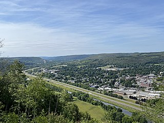
Erwin is a town in Steuben County, New York, United States. The population was 8,090 at the 2020 census. The name is that of an early settler, who became the first Town Supervisor. Erwin is in the southeast part of the county and is west of the city of Corning.

<span class="mw-page-title-main">Howard, New York</span> Town in New York, United States

Howard is a town in Steuben County, New York, United States. The population was 1,380 at the 2020 census.

Prattsburgh is a town in Steuben County, New York, United States. The population was 1,985 at the 2020 census. It is situated in the northeast part of the county, north of Bath.

Pulteney is a town in Steuben County, New York, United States. The population was 1,260 at the 2020 census. The name is derived from the name of the original pioneer tract of land.

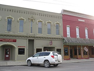
Savona is a village in Steuben County, New York, United States. The population was 827 at the 2010 census. The village is named after Savona in Italy, and is located in the eastern part of the town of Bath. The village is located at the intersection of routes 226 and 415, and Interstate 86.

Urbana is a town in Steuben County, New York, United States. The population was 2,125 at the 2020 census.

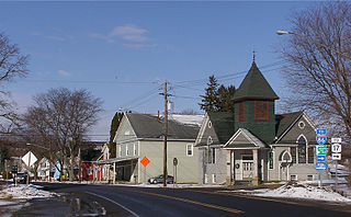
Wayne is a town located in the northeast corner of Steuben County, New York, United States. As of the 2020 census, the town population was 1,006. The town was named after the Revolutionary War general, Anthony Wayne.

<span class="mw-page-title-main">Wheeler, New York</span> Town in New York, United States

Wheeler is a town in Steuben County, New York, United States. The population was 1,136 at the 2020 census. The town is named after Captain Silas Wheeler, an early settler.

<span class="mw-page-title-main">Neversink, New York</span> Town in New York, United States

Neversink is a town in Sullivan County, New York, United States. The population was 3,366 at the 2020 census.

<span class="mw-page-title-main">Avoca, New York</span> Town in New York, United States

Avoca is a town in Steuben County, New York, United States. The population was 1,996 at the 2020 census.

<span class="mw-page-title-main">Bath (village), New York</span> Village in New York, United States

Bath is a village and the county seat of in Steuben County, New York, United States. The population was 5,786 at the 2010 census. The village is located in the town of the same name, northwest of Elmira and west of Tyrone.

Cohocton is a town in Steuben County, New York, United States. The population was 2,268 at the 2020 census. The town contains a village, also called Cohocton and is located in the northwestern part of the county.

Wayland is a town in Steuben County, New York, United States. The population was 3,733 at the 2020 census.

References

  1. "2016 U.S. Gazetteer Files". United States Census Bureau. Retrieved July 5, 2017.
  2. 1 2 3 Bureau, US Census. "City and Town Population Totals: 2020—2021". Census.gov. US Census Bureau. Retrieved October 3, 2022.
  3. The Delaware, Lackawanna and Western Railroad in the Nineteenth Century, Thomas T. Taber III, 1977, Lycoming Printing Company, Williamsport, PA
  4. 1 2 Clayton, 1879, p. 173
  5. Climate Summary for Bath, New York
  6. "Census of Population and Housing". Census.gov. Retrieved June 4, 2015.
  7. "U.S. Census website". United States Census Bureau . Retrieved January 31, 2008.
  8. "Grave of George Brinski". Polonia Trail. Retrieved December 18, 2021.
  9. "Golden State Killer". mercurynews.com. Retrieved April 25, 2014.
  10. "Offender (Deceased) - Richard William Davis".
  11. Hunter, Carol (1993). To Set the Captives Free: Reverend Jermain Wesley Loguen and the Struggle for Freedom in Central New York, 1835-1872. Garland. pp. 212–213. ISBN   978-0-8153-1014-3.

Sources