Related Research Articles

Bath is the largest city in the county of Somerset, England, known for and named after its Roman-built baths. In 2019, the population was 101,106. Bath is in the valley of the River Avon, 97 miles (156 km) west of London and 11 miles (18 km) southeast of Bristol. The city became a World Heritage Site in 1987, and was later added to the transnational World Heritage Site known as the "Great Spa Towns of Europe" in 2021.

Somerset is a county in South West England which borders Gloucestershire and Bristol to the north, Wiltshire to the east, Dorset to the south-east and Devon to the south-west. It is bounded to the north and west by the Severn Estuary and the Bristol Channel, its coastline facing southeastern Wales. Its traditional border with Gloucestershire is the River Avon. Somerset's county town is Taunton.
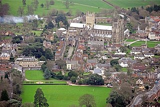
Wells is a cathedral city and civil parish in the Mendip district of Somerset, located on the southern edge of the Mendip Hills, 21 miles (34 km) south-east of Weston-super-Mare, 22 mi (35 km) south-west of Bath and 23 mi (37 km) south of Bristol. Although the population recorded in the 2011 census was only 10,536, and with a built-up area of just 3.244 square kilometres, Wells has had city status since medieval times, because of the presence of Wells Cathedral. Often described as England's smallest city, it is actually second smallest to the City of London in area and population, but unlike London it is not part of a larger urban agglomeration.

Bath and North East Somerset (B&NES) is a unitary authority district in England. Bath and North East Somerset Council was created on 1 April 1996 following the abolition of the county of Avon. It is part of the ceremonial county of Somerset.

The Mendip Hills is a range of limestone hills to the south of Bristol and Bath in Somerset, England. Running from Weston-super-Mare and the Bristol Channel in the west to the Frome valley in the east, the hills overlook the Somerset Levels to the south and the Chew Valley and other tributaries of the Avon to the north. The hills give their name to the local government district of Mendip, which administers most of the area. The higher, western part of the hills, covering 198 km2 (76 sq mi) has been designated an Area of Outstanding Natural Beauty (AONB), which gives it a level of protection comparable to a national park.

In England, a civil parish is a type of administrative parish used for local government. It is a territorial designation which is the lowest tier of local government below districts and counties, or their combined form, the unitary authority. Civil parishes can trace their origin to the ancient system of ecclesiastical parishes which historically played a role in both secular and religious administration; civil and religious parishes were formally differentiated in the 19th century and are now entirely separate. Civil parishes in their modern form came into being through the Local Government Act 1894, which established elected parish councils to take on the secular functions of the parish vestry.
Midsomer Norton is a town near the Mendip Hills in Bath and North East Somerset, England, 10 miles (16 km) south-west of Bath, 10 miles (16 km) north-east of Wells, 10 miles (16 km) north-west of Frome, 12 miles (19 km) west of Trowbridge and 16 miles (26 km) south-east of Bristol. It has a population of around 13,000. Along with Radstock and Westfield it used to be part of the conurbation and large civil parish of Norton Radstock, but is now a town council in its own right. It is also part of the unitary authority of Bath and North East Somerset.
The London Metropolitan Archives (LMA) is the principal local government archive repository for the Greater London area, including the City of London: it is the largest county record office in the United Kingdom. It was established under its present name in 1997, having previously been known as the Greater London Record Office. It is administered and financed by the City of London Corporation.

Newton St Loe is a small Somerset village and civil parish located close to the villages of Corston and Stanton Prior, between Bath and Bristol in England. The majority of the village is owned by the Duchy of Cornwall. The parish has a population of 681.
Greater Bristol is a term used for the conurbation which contains and surrounds the city of Bristol in the South West of England. There is no official "Greater Bristol" authority, but the term is sometimes used by local, regional and national authorities, and others as a synonym for either the "Bristol Urban Area" or a wider area of the former County of Avon, and by some, TfGB, to refer to the Province of Bristol as defined by C. B. Fawcett (1919) or Derek Senior (1969). The Bristol post town covers a wider area than the city of Bristol.
Priston is a civil parish and village 4 miles (6 km) south west of Bath in Bath and North East Somerset, which is within the English ceremonial county of Somerset. The parish includes the hamlet of Wilmington.
Clutton is a village and civil parish on the eastern edge of the affluent Chew Valley, close to the Cam Brook river, in the Bath and North East Somerset Council area, within the ceremonial county of Somerset, and straddles both the A37 and A39. It is located 9 miles (14 km) from Bristol and Bath, and 11 miles (18 km) from Wells. Nearby are the villages of Temple Cloud, High Littleton and Chelwood. The town of Midsomer Norton is 5 miles (8 km) away. The parish, which includes the hamlets of Clutton Hill and Northend has a population of 1,602.

Somerset County Council is the county council of Somerset in the South West of England, an elected local government authority responsible for the most significant local government services in most of the county.

Oxfordshire History Centre is in the former Church of England parish church of St Luke, Cowley, Oxford, England. It collects, preserves and makes available the records of the historic county of Oxfordshire. It holds original records and printed material from the 12th to 21st century, which are available for all to see free of charge. It is owned and run by Oxfordshire County Council. It is recognised as a place of deposit by The National Archives.
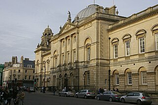
Guildhall is an 18th-century municipal building in central Bath, Somerset, England. It is a Grade I listed building.
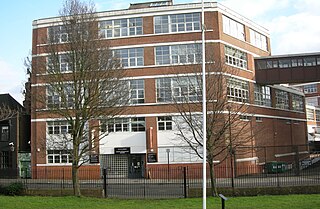
The City of Bath Technical School in Bath, Somerset, England had various roles from the late 19th century until 1970. It obtained its official name when technical schools were formally introduced in Bath between the years 1892 and 1896, and at first was housed in a new extension of the Guildhall. The school was transformed in the early 20th century, when it was combined with several other institutions, and then evolved through various sites and roles until its closure at Brougham Hayes, Lower Oldfield Park in 1973 after being renamed in 1971 as Culverhay School.

The Hull History Centre is an archive and local studies library in Hull, England, that houses the combined collections of both the Hull City Council and Hull University archives and local studies resources. This collaboration between Hull City Council, Hull University, and the Heritage Lottery Fund made Hull the first city in the UK to unite local council and university collections under one roof.
In the United Kingdom the term county record office usually refers to a local authority repository, also called a county archives.

The Somerset Archives and Local Studies holds the archives for the county of Somerset, England. The archives are held at Brunel Way, Langford Mead, Norton Fitzwarren, Taunton, and run by Somerset County Council.