Battle of Turtuk

Last updated

Battle of Turtuk
Part of the Indo-Pakistani War of 1971
Date8–14 December 1971
(6 days)
Location 34°50′42″N76°49′41″E / 34.845°N 76.828°E / 34.845; 76.828
Result Indian victory [1] [2]
Territorial
changes
India captures 800 km2 (310 sq mi) of Pakistani territory [3]
Belligerents
Flag of India.svg  India Flag of Pakistan.svg  Pakistan
Commanders and leaders
Unknown
Units involved
Ladakh Scouts
Nubra Guards
Karakoram Scouts
Gilgit Scouts
Strength
860-1,400 personnel 500-700 personnel
Casualties and losses
Heavy Heavy
Kashmir location map.svg
Red pog.svg
Turtuk
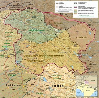
Location of the battle with geopolitical borders in present-day Ladakh

The Battle of Turtuk was a military engagement between India and Pakistan that took place during the Indo-Pakistani War of 1971. Fighting between the two sides took place in Turtuk and its surrounding areas, then part of the Pakistani-administered Northern Areas in Kashmir. Following this battle, Indian forces captured Turtuk from Pakistan, which had controlled the area since the Indo-Pakistani War of 1947–1948. [1] Per the Simla Agreement, Turtuk was incorporated into the erstwhile Indian-administered state of Jammu and Kashmir, and formally became a part of Ladakh following the revocation of Article 370 by the Government of India in August 2019.

Contents

Background

The village of Turtuk is situated in a strategically important location, as it lies in the immediate vicinity of the Line of Control, which separates it from Pakistani-administered Gilgit−Baltistan to its north. It is also in relatively close proximity to the Line of Actual Control in the east, which separates Indian-administered Ladakh from the Chinese-administered territory of Aksai Chin. [4]

The area is extremely inhospitable and the land is rugged, with deep narrow gorges and ravines. The climate is dry and cold with temperatures falling to −25 °C (−13 °F). [2]

The Turtuk sector covers the entire Shyok river valley. In 1971, the sector came under the operational responsibility of the 3 Division of the Indian Army, based in Leh and commanded by Maj Gen S.P. Malhotra. [2] The Indian base of operations was located in the Nubra valley, also known as Partapur sector. The sector was connected to Leh via a single lane road over the Khardung La pass, which at 17,582 ft is the highest motorable pass in the world. [3] [5]

Preliminary formations

The Indian sector commander was Col Udai Singh who commanded a force of 5 companies of the Ladakh Scouts, of which 2 were committed to defending the Chinese border. In order to enable the 3 available companies for offensive action, 550 members of the local population were recruited and trained to form 4 companies of Nubra Guards. These were mainly tasked with static duties and for defensive duties. The 3 companies of Ladakh Scouts were supported by 2 platoons of the Nubra Guards, 2 sections of 81mm mortars and 2 sections of MMGs. [1]

The defending Pakistani force consisted of 1 company of Karakoram Scouts and 1-2 companies of mixed Karakoram and Gilgit Scouts. These were supported by three 75-mm guns, a section of 3.7-inch howitzers and six three-inch mortars. The Pakistani positions were well prepared with the approaches mined. [2] [3]

The battle

While approaching the LoC from the Diskit on Indian side along the Indus River, the sector has the following features in the east to west sequence: Diskit, Bogdang, Chalunka (Chulunkha), Pt 18,402 peak, Turtuk, Tyaksi, Tyakshi Pachathang, Thang - all of which are now in Indian control. Presently as of 2023 in the Pakistani administered area are first Frano (Phrano) village and then Thagmus.

The Indian attack was led by the Major Chewang Rinchen, who had earlier earned an MVC in the 1947 Pakistan War and a Sena Medal in the 1962 China war. On the first day, the force advanced to a place called Baigdangdo (Bogdang), driving for 40 km in jeeps and the next 40 km by foot. The next day, the unit had the option to attack the Pakistani defenses either via the steep mountainous paths or along the Shyok river. Major Chewang Rinchen decided to use the mountain paths as the approach along the Shyok river was expected to be well covered by machine gun nests as well as well mined. This would also have the benefit of taking the enemy by surprise and avoiding heavy fighting. [6]

On 8 December, the force captured a Pakistani picquet on the top of the mountain known as Pt 18402. A platoon was also tasked to silently approach the back of Pt 18,402 and take control of the Pakistani line of communication. From the top of Pt 18402, the entire valley from Turtok and Chulunkha in the West, to the Indian headquarters at Partapur and the airfield at Thoise in the east was visible. After this, Major Chewang Rinchen's unit climbed town from Pt 18402 towards the Pakistani camp on the other side. When it reached the camp, it was found to have been abandoned and a large stock of supplies and ammunition was captured. [6]

On 9 December, the Indian force while approaching the Pakistani base camp of Chulunkha defence complex and encountered heavy mortar and machine gun fire from multiple sides. The force was able to overcome the heavy firing and capture the Chulunkha defence complex. [6]

The next task was to capture Turtuk on the left bank of the Shyok river. On 14 December, the force commenced the advance to take Turtuk village attack while simultaneously commencing mortar fire on the Pakistani defences to soften them up. When the mortar fire stopped and the force entered Turtuk village, it found that the Pakistani defenders had fled the previous night. Only the menfolk of the village were still present in the village while the women and children were hiding in a nullah nearby, afraid of violence and atrocities by the Indian troops. Major Rinchen was able to reassure the villagers of their safety and told them "The Indian Army will help you in all respects. Bring back your womenfolk and children. They are like our mothers and sisters. I will be responsible for their safety, if there is any misbehaviour on the part of any soldier or civilian who has come with us, I shall take disciplinary action against the person who misbehaves." [6]

The next day, Major Rinchen and his unit proceeded to Tyakshi and Pachethang. By that time Pakistani forces had withdrawn, so the unit faced no resistance in capturing these 2 objectives. [6]

On 17 December morning, the unit prepared to launch an attack on Prahnu and Piun, however on the same afternoon, the Pakistan government agreed to a ceasefire and the Indian forces were ordered to cease fire. [1] [3] [2]

Result

The battle resulted in India's capture of around 800 sq km of mostly mountains of Ladakh Range and Karakorum Range, Mountains ranging in height from 18,000 to 23,000 feet high and four small villages of Turtuk, Chalunkha, Thang, and Takshi were captured from Pakistani-administered Kashmir. The capture of Point 18402, the highest post ever captured, was a major strategic victory as from this point the entire Shyok valley stretching from Turtuk and Chulunkha in the East, to the Indian headquarters at Partapur and the airfield at Thoise in the west were visible and therefore exposed to attack and observation. [3]

Under the Shimla Agreement, India gave back more than 13,000 km2 of land that the Indian Army had seized in Pakistan during the war, though India retained a few strategic areas of PoK )which is administered by Pakistan and claimed by India), including Turtuk, Dhothang, Tyakshi (earlier called Tiaqsi) and Chalunka of Chorbat Valley, [7] [8] which was more than 883 km2. [9] [10] [11]

See also

Related Research Articles

<span class="mw-page-title-main">Baltistan</span> Region of Pakistani-administered Kashmir

Baltistan also known as Baltiyul or Little Tibet, is a mountainous region in the Pakistani-administered territory of Gilgit–Baltistan. It is located near the Karakoram and borders Gilgit to the west, China's Xinjiang to the north, Indian-administered Ladakh to the southeast, and the Indian-administered Kashmir Valley to the southwest. The average altitude of the region is over 3,350 metres (10,990 ft). Baltistan is largely administered under the Baltistan Division.

<span class="mw-page-title-main">Nubra</span> Region in Ladakh, India

Nubra, also called Dumra, is a historical region of Ladakh, India that is currently administered as a subdivision and a tehsil in the Leh district. Its inhabited areas form a tri-armed valley cut by the Nubra and Shyok rivers. Its Tibetan name Dumra means "valley of flowers". Demands have been raised and BJP has hinted at creation of Nubra as a new district. Diskit, the headquarters of Nubra, is 120 km north of Leh, the capital of Ladakh.

<span class="mw-page-title-main">Ghanche District</span> District of Gilgit-Baltistan administered by Pakistan in Gilgit-Baltistan

Ghanche District is a district of Pakistan-administered Gilgit-Baltistan in the disputed Kashmir region. It is the eastern-most district of Gilgit-Baltistan. It is the coldest place within Pakistan as it is situated on the "third pole", with temperatures reaching below -20 °C in the winter. The Khaplu Valley and the Hushe Valley form the gateway for the great Baltoro Muztagh, the subrange of the Karakoram Mountains that includes the mighty peaks of K2, Broad Peak, the Gasherbrums and Masherbrum ,all of which are also included in the Skardu District).

<span class="mw-page-title-main">Geography of Ladakh</span> Aspect of geography

Ladakh is an administrative territory of India that has been under its control since 1947. The geographical region of Ladakh union territory is the highest altitude plateau region in India, incorporating parts of the Himalayan and Karakoram mountain ranges and the upper Indus River and valley.

<span class="mw-page-title-main">Tourism in Ladakh</span>

Tourism is one of an economic contributor to the union territory of Ladakh in Northern India. The union territory is sandwiched between the Karakoram mountain range to the north and the Himalayas to the south and is situated at the height of 11,400 ft. Ladakh is composed of the Leh and Kargil districts. The region contains prominent Buddhist sites and has an ecotourism industry.

<span class="mw-page-title-main">Shyok River</span> River in India and Pakistan

The Shyok River is a tributary of the Indus River that flows through northern Ladakh and enters Gilgit–Baltistan, in Pakistan, spanning some 550 km (340 mi).

Colonel Chewang Rinchen MVC & Bar, SM was a highly decorated officer in the Indian Army from the Union territory of Ladakh. He was the youngest ever recipient of the Maha Vir Chakra, the second highest Indian gallantry decoration, for his role in the defence of Ladakh in the First Kashmir War. He received the Maha Vir Chakra for a second time after Indo-Pakistani War of 1971, for his role in the conquest of the Turtuk and Tyakshi, in what came to be known as the Battle of Turtuk. He was one of only six Indian service personnel to have the Maha Vir Chakra twice. He was awarded a Sena Medal for gallantry in the 1962 India-China War. and Mention in dispatches for gallantry in the Indo-Pakistani War of 1965

Chalunka is a small mountainous village, in Nubra tehsil and Turtuk community development block, in Chorbat area of Shyok River valley in Ladakh, India. At the end of the Indo-Pakistani War of 1947, it was on the cease-fire line agreed between the India and Pakistan. After the Indo-Pakistani War of 1971, the village came under the jurisdiction of Indian-administered Jammu & Kashmir.

<span class="mw-page-title-main">Siachen Base Camp (India)</span>

Siachen Base Camp, 12,000 feet above sea level at Partapur, is a base camp of 102 Infantry Brigade of XIV Corps of Indian Army which protects 110 km long Actual Ground Position Line (AGPL) with at least 108 forward military outposts and artillery observation posts in the disputed region of Siachen Glacier in Ladakh Union Territory of India. It is approximately 6 hours drive north from the town of Leh via one of the highest vehicle-accessible passes in the world, Khardung La at 17,582 feet. Bana Top (20,500 ft) is the highest post in the region, which requires 80 km and 20 day trek for troops. Pahalwan Post and posts near Indira Col are other high posts. Kumar Post or Kumar Base, named after the Colonel Narendra "Bull" Kumar, serves as the battalion head quarter located 60 km from the Siachen base towards Indira Col. The Siachen Brigade consists of five to eight battalions of Ladakh Scouts supported by artillery, air defence, engineer and other logistic units. Pakistan has not been able to scale the crest of the Saltoro Range occupied by India. The temperature goes down to minus 86 °C during winters with icy 300 kmph blizzards. The average temperature is between minus 25 °C during day and minus 55 °C during the night.

<span class="mw-page-title-main">Diskit Monastery</span> Buddhist monastery in Ladakh, India

Diskit Monastery also known as Deskit Gompa or Diskit Gompa is the oldest and largest Buddhist monastery (gompa) in Diskit, Nubra Valley of the Leh district of Ladakh. It is 115 km north of Leh.

NJ9842, also called NJ 980420, is the northernmost demarcated point of the India-Pakistan cease fire line in Kashmir known as the Line of Control (LoC). The India–Pakistan AGPL, begins from the NJ9842 on LoC and ends near the Indira Ridge at the trijunction of areas controlled by China, India, and Pakistan.

<span class="mw-page-title-main">Turtuk</span> Village in Ladakh, India

Turtuk is a village and the headquarters of an eponymous community development block in the Indian union territory of Ladakh. It is a small village sandwiched between the Karakorum Range and the Himalayas, and one of the northernmost villages of India, close to the Line of Control between India and Pakistan. Turtuk is situated in the Nubra tehsil of the Leh district, on the banks of the Shyok River. Geographically, the village is in the Baltistan region, which has been under Pakistani administration, except for five villages of the Turtuk block which are part of India. These villages form the only region in India populated by Balti people. Turtuk is known for its fruit, especially apricots.
<span class="mw-page-title-main">Ladakh Scouts</span> Infantry regiment of the Indian Army

The Ladakh Scouts is an infantry regiment of the Indian Army, nicknamed as the "Snow Warriors" or "Snow Leopards". The regiment specializes in mountain warfare, and its primary role is to guard India's borders in the high altitudes of the Union Territory of Ladakh.

<span class="mw-page-title-main">Chorbat Valley</span> Valley in Gilgit-Baltistan & Ladakh, Pakistan & India

Chorbat Valley is a section of the Shyok river valley divided between Pakistan-administered Gilgit-Baltistan and Indian-administered Ladakh. The Pakistan-administered portion is in the Khaplu tehsil of Ghanche District in Gilgit–Baltistan, and the Indian-administered portion is in the Nubra tehsil, Leh district of Ladakh. Chorbat stretches from the edge of Khaplu to the Chalunka village of Nubra.

Bogdang is a village in the Leh district of Ladakh, India. It is located in Nubra tehsil.

Thang is a small village in the Leh district of Ladakh, India. It is in the historical Chorbat region of Baltistan, divided between India and Pakistan by the 1972 Line of Control. Thang is part of the Nubra tehsil and the Turtuk community development block.

Durbuk or Darbuk, is a village and the headquarters of the eponymous subdivision and block in the Leh district of Ladakh, India. It is located in the Durbuk tehsil, and falls between Chang La mountain pass and Tangste village on the way to Pangong Tso Lake.

Takshi, also known as Tyakshi or Taqsi, is a remote village in Nubra valley, located on the banks of the Shayok River in the Leh district of UT Ladakh, India. It lies in the historical Chorbat Valley of the Baltistan region, which was divided between India and Pakistan by the modified ceasefire line that was established in the 1972 Shimla Agreement. Tyakshi, along with Chalunka, Turtuk and Thang, became part of the Pakistani-administered Northern Areas following the Indo-Pakistani War of 1947–1948. All four of these villages were captured by Indian forces during the Indo-Pakistani War of 1971, after which they were incorporated into the erstwhile Indian-administered state of Jammu and Kashmir. Following the revocation of Article 370 by the Government of India in August 2019, Tyakshi formally fell under the jurisdiction of the Indian-administered union territory of Ladakh. After 1971 war four villages Pakistan controlled Kashmir were retained by India while many Indian villages in Chhamb sector were retained by Pakistan and line of control was defined.

The Nubra Guards was an Indian paramilitary force formed during the Indo-Pakistani War of 1947–1948 to provide security in the Nubra Tehsil, in particular the Nubra and Shyok river valleys. Diskit, the headquarters of Nubra, is about 150 km north from Leh town, the capital of Ladakh district. The Guard was originally formed by Chewang Rinchen whose family was from the area. In April 1948 the Guards were at company strength. The Guard was re-raised several times and resisted the Pakistani invasion of Jammu and Kashmir.

The Darbuk–Shyok–DBO Road, also called the Sub-Sector North Road, is a strategic all-weather road in eastern Ladakh in India, close to the Line of Actual Control with China. It connects Ladakh's capital city Leh, via the villages of Darbuk and Shyok at southern Shyok River Valley, with the Daulat Beg Oldi (DBO) post near the northern border. The 220-km long section between Shyok and DBO was constructed between 2000 and 2019 by India's Border Roads Organisation (BRO). The DS-DBO Road has reduced the travel time between Leh to DBO from 2 days to 6 hours. In January 2023, BRO announced that it is constructing the DSDBO tunnel on this route.

References

  1. 1 2 3 4 Col Y Udaya Chandar (Retd) (2 January 2018). Independent India's All the Seven Wars. Notion Press. p. 402. ISBN   9781948473224.
  2. 1 2 3 4 5 "Defence of the Western Border - III". Indian Defence Review. 5 August 2011.
  3. 1 2 3 4 5 Arpi, Claude (22 December 2011). "Have you heard about this Indian Hero?". Rediff news.
  4. Gill, Gauri (28 June 1999). "The Siachen Factor". Outlook India.
  5. Ranvir Vohra, Ansh (25 January 2018). "Turtuk: The Village That Became Indian Overnight in the 1971 War". Quint.
  6. 1 2 3 4 5 "Rinchen's second victory of the day". Rediff News. 22 December 2011.
  7. "Turtuk, a Promised Land Between Two Hostile Neighbours". The Wire. Archived from the original on 30 October 2020. Retrieved 27 October 2020.
  8. Rajrishi Singhal, qz com. "An encounter with the 'king' of Turtuk, a border village near Gilgit-Baltistan". Scroll.in. Archived from the original on 24 October 2020. Retrieved 27 October 2020.
  9. "A portrait of a village on the border". 10 August 2017. Archived from the original on 26 August 2017. Retrieved 26 August 2017.
  10. "Have you heard about this Indian Hero?". Rediff.com. 22 December 2011. Archived from the original on 14 June 2017. Retrieved 28 May 2015.
  11. "The Simla Agreement 1972". Story of Pakistan. Archived from the original on 14 June 2011. Retrieved 20 October 2009.