Battle of the Twin Villages

Last updated
Spanish Fort, Texas
USA Texas location map.svg
Red pog.svg
Battle of the Twin Villages
Location of the Battle of the Twin Villages in Texas or Oklahoma
Location Montague County, Texas
Nearest city Nocona, Texas
Coordinates 33°57′7.2318″N97°37′36.0948″W / 33.952008833°N 97.626693000°W / 33.952008833; -97.626693000
Area100 acres (40 ha)
Built1759
NRHP reference No. 75002000
 No.369976
Significant dates
Significant Event1759
Added to NRHPApril 14, 1975
Designated April 14, 1975

The Battle of the Two Villages was a Spanish attack on Taovaya villages in Texas and Oklahoma by a Spanish army in 1759. The Spanish were defeated by the Taovaya and other Wichita tribes with assistance from the Comanche.

Contents

Background

The San Saba Mission was established in April 1757 near the site of present day Menard, Texas. Three miles away, a military post, Presidio San Luis de las Amarillas, was established at the same time to protect the Mission. The purpose of the Mission was to convert and pacify the Lipan Apache and extend Spanish influence into the Great Plains. [1] The Spanish also wished to check the increase in French influence among the Indians on their northern frontier.

The destruction of the San Saba mission is depicted in the earliest extant painting of an event in Texas history. SanSabaDestruction.jpg
The destruction of the San Saba mission is depicted in the earliest extant painting of an event in Texas history.

The establishment of the Mission inflamed the Indians of northern Texas, called "Norteños" by the Spanish. The Norteños included the nomadic Comanche, the village-dwelling Wichita tribes, (the Taovaya, Iscani, and Wichita proper), and Tonkawan tribes. On March 16, 1758, an Indian army, described as numbering 2,000 men, destroyed the San Saba Mission, killing two Franciscan priests and several Christian Indian assistants. The nearby Presidio, staffed by fewer than 100 soldiers, was too weak to attempt to protect the Mission. [3] Raids continued near the Presidio. In December, Comanche killed 21 Apache and, in March 1759, another 18 men guarding the Presidio's horse herd. [4]

The Commander of the San Luis Presidio, Diego Ortiz Parrilla, an experienced soldier and Indian fighter, organized a punitive mission against the Norteños, especially the Wichita. The force he slowly assembled consisted of two cannons, 1,600 horses, mules, and cattle, and 636 men: 139 Spanish soldiers, 241 militiamen, 134 Apache Indians, 30 Tlaxcalan Indians, 90 Christian Mission Indians, and two priests. The soldiers and the Tlaxcalans were armed with muskets and swords; the Indians mostly with bows and arrows. In August 1759, this unwieldy and mostly untrained force set forth northward from San Antonio. Ortiz Parrilla had supplies for a four-month expedition. [5]

The Indian tribes

The Wichita were farming Indians who lived in beehive-shaped houses thatched with grass and surrounded by extensive maize fields. They were skilled farmers who traded agricultural products to nomadic tribes in exchange for meat. Wichita Indian village 1850-1875.jpg
The Wichita were farming Indians who lived in beehive-shaped houses thatched with grass and surrounded by extensive maize fields. They were skilled farmers who traded agricultural products to nomadic tribes in exchange for meat.

The Wichita Indians had only recently migrated south from their traditional homeland of Kansas and northern Oklahoma. Their migration was prompted by pressure from the Osage expanding onto the Great Plains. In the early 1750s, the Taovaya, the most important of the several Wichita tribes, had established large twin villages on the north side of Red River in Jefferson County, Oklahoma and on the south side at Spanish Fort, Texas. The Wichita had trade contacts with the French and in 1746 a French-brokered alliance with the Comanche contributed to their prosperity. The village at Spanish Fort became "a lively emporium where Comanches brought Apache slaves, horses and mules to trade for French packs of powder, balls, knives, and textiles and for Taovaya-grown maize, melons, pumpkins, squash, and tobacco." [6] The Taovaya villages were the objective of the Spanish army.

The Comanche were also migrating south toward the Spanish settlements in Texas and driving the Apache before them. They were among the first North American Indians to acquire the horse from the Spanish and to create the nomadic, equestrian culture that would typify the Plains Indians. The Comanche were powerful and numerous, although divided into several independent bands. They were in the process of establishing suzerainty over a large area of the southern Great Plains with allies such as the Wichita.

The Tonkawa consisted of a number of independent tribes that spoke similar languages. They lived in central and northern Texas. Other Indians identified as participating in Norteño raids were Bidai, Tejas (Hasinai), and Yojuanes. The various tribes making up the people the Spanish called Norteños were united only in that they shared a common enemy, the Apache, and a concern that a Spanish-Apache alliance would be detrimental to their interests. [7]

The battle

The first problem of the Spanish expedition was finding the Norteños. On October 2, Ortiz Parrilla found a Yojuane village, probably along the Clear Fork of the Brazos River near present day Graham, Texas. Attacking the village, the Spanish killed 49 Yojuanes and captured 149. Some of the captive Yojuanes offered to guide Ortiz Parilla north to a large Taovaya and Iscani village. [8]

On October 7, about 60 or 70 Indians attacked the Spanish. The Spanish formed up in line of battle and dispersed the small Indian force, pursuing them through the woods to the banks of a river, undoubtedly the Red. The Spanish were surprised to find there a moated fort flying a French flag. Inside the palisaded wall were the distinctive bee-hive shaped houses of the Wichita. The inhabitants of houses outside the palisade fled to the fort for shelter. Upstream were large fields of maize, pumpkins, beans, and watermelons. Downstream was a ford across the river, guarded by Indian warriors. The Spanish could also see Comanche tipis scattered around the periphery of the village. [9]

Spanish estimates of the numbers of the Indians they faced ranged up to 6,000, of whom 500 were mounted, although Ortiz Parrilla estimated only that the Indians numbered at least as many as his force of 600. He deployed the Tlaxcalans and Mission Indians on the right, the Spanish in the center, and the Apache on the left. His plan was to advance on and storm the fortress, supported by his two cannon. Indians, however, menaced his flanks, and sallied from the fort in repeated assaults on the Spanish lines. Each warrior on horseback had two men on foot supporting him, each carrying two additional loaded muskets. Indian scouts reported that 14 Frenchmen were inside the fortress helping direct the fighting. [10]

The battle lasted four hours. The Spanish were unable to approach the palisaded village. The eleven volleys of cannon fire they directed at the palisade were ineffective. The fighting ceased at nightfall and the Spanish reassessed their situation. The Indians had captured their two cannons, 19 men in the Spanish army, mostly Spaniards, were dead and 14 were wounded. A number of men had deserted. The priests and officers petitioned Ortiz Parrilla to abandon the fight. Next morning, he ordered a return to San Saba which the Spanish force and their Yojuane captives reached on October 25. The Spanish estimated that they had killed 100 Indians in the battle, probably a large over-estimation. [11]

Aftermath

The Yojuane captives were sold into slavery and the group soon disappeared from history, the survivors being absorbed by the Tonkawa. Neither the Spanish nor the Norteños followed up the battle with any serious military action. The Wichita tribes later sought peace with the Spanish and refrained from further raids. In 1767, the Spanish abandoned the San Saba mission and their efforts to Christianize the Apache. The Spanish peace with the Apache soon broke down and Apache and Comanche raiders continued to be a serious threat on the northern frontier of Spanish settlements. [12]

It is uncertain whether the battle took place on the Texas or the Oklahoma side of the Red River. [13] The traces of the village remaining on the Oklahoma side of the border are now called the Longest archaeological site. [14]

See also

Related Research Articles

<span class="mw-page-title-main">Jefferson County, Oklahoma</span> County in Oklahoma, United States

Jefferson County is a county located in the U.S. state of Oklahoma. As of the 2020 census, the population was 5,337. Its county seat is Waurika. The county was created at statehood and named in honor of President Thomas Jefferson.

<span class="mw-page-title-main">Quanah Parker</span> Native American Indian leader, Comanche (c. 1845–1911)

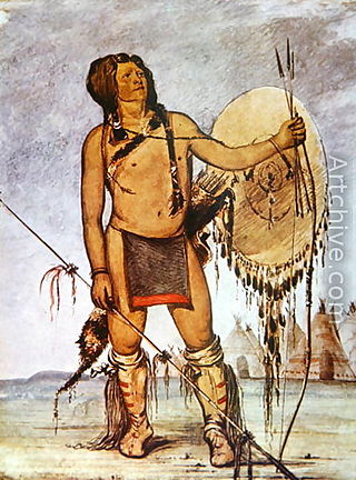
Quanah Parker was a war leader of the Kwahadi ("Antelope") band of the Comanche Nation. He was likely born into the Nokoni ("Wanderers") band of Tabby-nocca and grew up among the Kwahadis, the son of Kwahadi Comanche chief Peta Nocona and Cynthia Ann Parker, an Anglo-American who had been abducted as a nine-year-old child and assimilated into the Nokoni tribe. Following the apprehension of several Kiowa chiefs in 1871, Quanah Parker emerged as a dominant figure in the Red River War, clashing repeatedly with Colonel Ranald S. Mackenzie. With European-Americans hunting American bison, the Comanches' primary sustenance, into near extinction, Quanah Parker eventually surrendered and peaceably led the Kwahadi to the reservation at Fort Sill, Oklahoma.

Lipan Apache are a band of Apache, a Southern Athabaskan Indigenous people, who have lived in the Southwest and Southern Plains for centuries. At the time of European and African contact, they lived in New Mexico, Colorado, Oklahoma, Texas, and northern Mexico. Historically, they were the easternmost band of Apache. Early adopters of horse culture and peyotism, the Lipan Apache hunted bison and farmed.

<span class="mw-page-title-main">Wichita people</span> Confederation of Native Americans

The Wichita people or Kitikiti'sh are a confederation of Southern Plains Native American tribes. Historically they spoke the Wichita language and Kichai language, both Caddoan languages. They are indigenous to Oklahoma, Texas, and Kansas.

<span class="mw-page-title-main">Comanche Wars</span> Conflicts over Comanche lands, 1706 to 1870s

The Comanche Wars were a series of armed conflicts fought between Comanche peoples and Spanish, Mexican, and American militaries and civilians in the United States and Mexico from as early as 1706 until at least the mid-1870s. The Comanche were the Native American inhabitants of a large area known as Comancheria, which stretched across much of the southern Great Plains from Colorado and Kansas in the north through Oklahoma, Texas, and eastern New Mexico and into the Mexican state of Chihuahua in the south. For more than 150 years, the Comanche were the dominant native tribe in the region, known as “the Lords of the Southern Plains”, though they also shared parts of Comancheria with the Wichita, Kiowa, and Kiowa Apache and, after 1840, the southern Cheyenne and Arapaho.

<span class="mw-page-title-main">Comancheria</span> Former region of the US Southwest occupied by the Comanche people

The Comancheria or Comanchería was a region of New Mexico, west Texas and nearby areas occupied by the Comanche before the 1860s. Historian Pekka Hämäläinen has argued that the Comancheria formed an empire at its peak, and this view has been echoed by other non-Comanche historians.

<span class="mw-page-title-main">Tonkawa</span> Indigenous people from Oklahoma

The Tonkawa are a Native American tribe indigenous to present-day Oklahoma. Their Tonkawa language, now extinct, is a linguistic isolate.

<span class="mw-page-title-main">Spanish Texas</span> Province of New Spain

Spanish Texas was one of the interior provinces of the colonial Viceroyalty of New Spain from 1690 until 1821. The term "interior provinces" first appeared in 1712, as an expression meaning "far away" provinces. It was only in 1776 that a legal jurisdiction called "Interior Provinces" was created.

<span class="mw-page-title-main">Spanish missions in Texas</span> 17th to 19th-century Catholic religious outposts

The Spanish Missions in Texas comprise a series of religious outposts established by Spanish Catholic Dominicans, Jesuits, and Franciscans to spread the Catholic doctrine among area Native Americans, but with the added benefit of giving Spain a toehold in the frontier land. The missions introduced European livestock, fruits, vegetables, and industry into the Texas area. In addition to the presidio and pueblo (town), the misión was one of the three major agencies employed by the Spanish crown to extend its borders and consolidate its colonial territories. In all, twenty-six missions were maintained for different lengths of time within the future boundaries of the state of Texas.

<span class="mw-page-title-main">Comanche history</span>

Comanche history is the story of the Native American (Indian) tribe which lived on the Great Plains of the present-day United States. In the 17th century the Eastern Shoshone people who became known as the Comanche migrated southward from Wyoming. In the 18th and 19th centuries the Comanche became the dominant tribe on the southern Great Plains. The Comanche are often characterized as "Lords of the Plains." They presided over a large area called Comancheria which they shared with allied tribes, the Kiowa, Kiowa-Apache, Wichita, and after 1840 the southern Cheyenne and Arapaho. Comanche power and their substantial wealth depended on horses, trading, and raiding. Adroit diplomacy was also a factor in maintaining their dominance and fending off enemies for more than a century. They subsisted on the bison herds of the Plains which they hunted for food and skins.

Jean-Baptiste Bénard de la Harpe was a French explorer who is credited with using the name "Little Rock" in 1722 for a stone outcropping on the bank of the Arkansas River used by early travelers as a landmark. Little Rock, Arkansas was subsequently named for the landmark.

The Texas–Indian wars were a series of conflicts between settlers in Texas and the Southern Plains Indians during the 19th-century. Conflict between the Plains Indians and the Spanish began before other European and Anglo-American settlers were encouraged—first by Spain and then by the newly Independent Mexican government—to colonize Texas in order to provide a protective-settlement buffer in Texas between the Plains Indians and the rest of Mexico. As a consequence, conflict between Anglo-American settlers and Plains Indians occurred during the Texas colonial period as part of Mexico. The conflicts continued after Texas secured its independence from Mexico in 1836 and did not end until 30 years after Texas became a state of the United States, when in 1875 the last free band of Plains Indians, the Comanches led by Quahadi warrior Quanah Parker, surrendered and moved to the Fort Sill reservation in Oklahoma.

<span class="mw-page-title-main">Mission Santa Cruz de San Sabá</span> Former Spanish mission in Texas

Mission Santa Cruz de San Sabá was one of the Spanish missions in Texas. It was established in April 1757, along with the Presidio San Luis de las Amarillas, later renamed Presidio of San Sabá, in what is now Menard County. Located along the San Saba River, the mission was intended to convert members of the Lipan Apache tribe. Although no Apache ever resided at the mission, its existence convinced the Comanche that the Spanish had allied with the Comanche's mortal enemy. In 1758 the mission was destroyed by 2,000 warriors from the Comanche, Tonkawa, Yojuane, Bidai and Hasinai tribes. It was the only mission in Texas to be completely destroyed by Native Americans. The Indians did not attack the nearby presidio.

<span class="mw-page-title-main">Presidio San Luis de las Amarillas</span> United States historic place

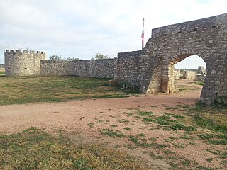
Presidio San Luis de las Amarillas, now better known as Presidio of San Sabá, was founded in April 1757 near present-day Menard, Texas, United States to protect the Mission Santa Cruz de San Sabá, established at the same time. The presidio and mission were built to secure Spain's claim to the territory. They were part of the treaty recently reached with the Lipan Apaches of the area for mutual aid against enemies. The early functioning of the mission and presidio were undermined by Hasinai, also allied with the Spanish, attacking the Apaches. The mission was located three miles downstream from the presidio by request of the monks at the mission to ensure that the Spanish soldiers would not be a corrupting influence on the Lipan Apaches the monks were trying to convert to Christianity. The original presidio and mission were built out of logs.

The Taovaya tribe of the Wichita people were Native Americans originally from Kansas, who moved south into Oklahoma and Texas in the 18th century. They spoke the Taovaya dialect of the Wichita language, a Caddoan language. Taovaya people today are enrolled in the Wichita and Affiliated Tribes, a federally recognized tribe headquartered in Anadarko, Oklahoma.

<span class="mw-page-title-main">Comanche–Mexico Wars</span>

The Comanche–Mexico Wars was the Mexican theater of the Comanche Wars, a series of conflicts from 1821 to 1870. The Comanche and their Kiowa and Kiowa Apache allies carried out large-scale raids hundreds of miles deep into Mexico killing thousands of people and stealing hundreds of thousands of cattle and horses. The Comanche raids were sparked by the declining military capability of Mexico during the turbulent years after it gained independence in 1821, as well as a large and growing market in the United States for stolen Mexican horses and cattle.

Don Pedro de Rábago y Terán was a Spanish administrator and military officer in New Spain, now Mexico. He was governor of Coahuila from August 1744 to June 1754. In 1754, Don Pedro de Rábago y Terán was sent by the viceroy of New Spain to find a site for an Apache Mission, named a pass between the hills in Menard County overlooking the San Saba River as Puerto de Baluartes. The Santa Cruz de San Sabá Mission was established three years later on the San Saba River near Menard, Texas. As an explorer in the late 1740s he went on three expeditions to the confluence of the Rio Grande and the Rio Conchos, known as La Junta de los Rios, in order to establish a presidio or military camp to serve six missions in the area of La Junta, which were being attacked by the Apache. He recommended a site that became the Presidio de la Junta de los Ríos Norte y Conchos near what is now Presidio, Texas.

<span class="mw-page-title-main">Presidio of San Sabá</span>

The Presidio of San Sabá was the second presidio established at the site of present-day Menard, Texas on the San Saba River. The first was the Presidio San Luis de las Amarillas, established by Colonel Diego Ortiz Parrilla in April 1757, the same time that Mission Santa Cruz de San Sabá was also founded by Fr. Alonso Giraldo de Terreros some three miles downstream. Initially, both the presidio and mission were enclosed by a wooden stockade. About 2,000 Comanche and Wichita warriors attacked and destroyed the mission March 16, 1758, but did not attack the presidio. Colonel Parrilla led a punitive expedition against the hostiles about one year later, but was defeated in the Battle of the Twin Villages at a large Wichita village on the Red River. Colonel Parrilla was relieved of command as a consequence of this setback and replaced by Captain Felipe de Rábago y Terán.

Pedro Vial, or Pierre Vial, was a French explorer and frontiersman who lived among the Comanche and Wichita Indians for many years. He later worked for the Spanish government as a peacemaker, guide, and interpreter. He blazed trails across the Great Plains to connect the Spanish and French settlements in Texas, New Mexico, Missouri, and Louisiana. He led three Spanish expeditions that attempted unsuccessfully to intercept and halt the Lewis and Clark Expedition.

Diego Ortiz Parrilla was an 18th-century Spanish military officer, governor, explorer, and cartographer.

References

  1. Weber, David J. (1992), The Spanish Frontier in North America, Yale Western Americana Series, New Haven, CT: Yale University Press, p. 188
  2. Ratcliffe, Sam D. "'Escenas de Maritiro': Notes on the Destruction of Mission San Sabá", The Southwestern Historical Quarterly, Vol. 94, No. 4 (Apr. 1991), Pp. 507-534
  3. "Twin Villages, Battle of the" Encyclopedia of Oklahoma History and Culture http://digital.library.okstate.edu/encyclopedia/entries/T/TW005.html Archived 2012-05-17 at the Wayback Machine , accessed 28 Dec 2012
  4. "Ortiz Parrilla Red River Campaign" Texas State Historical Association http://www.tshaonline.org/handbook/online/articles/poo01. accessed 28 Dec 2012
  5. Allen, Henry Easton. "The Parrilla Expedition to the Red River in 1759" The Southwestern Historical Quarterly, Vol. 43, No. 1 (July 1939), p. 65; "Two Villages, Battle of the" Encyclopedia of Oklahoma History and Culture http://digital.library.okstate.edu/encyclopedia/entries/T/TW005.html Archived 2012-05-17 at the Wayback Machine , accessed 28 Dec 2012
  6. Elam, Earl Henry, "Anglo-American Relations with the Wichita Indians in Texas, 1822-1859." Master's Thesis, Texas Technological College, 1967, 11
  7. John, Elizabeth A. H. Storms Brewed in other Men's Worlds Lincoln: University of Nebraska Press, 1975, pp. 297-298
  8. John, p. 350
  9. Allen, p. 67-68
  10. Allen, pp. 68-69; John, p. 351
  11. Allen, pp 69-70; John, pp. 351-352
  12. John, pp. 352-353
  13. John, p. 350
  14. Oklahoma Archaeological Society" http://www.ou.edu/cas/archsur/oas/scheduled-digs.html Archived 2013-05-23 at the Wayback Machine , accessed 18 Apr 2013