
A swamp is a forested wetland. Swamps are considered to be transition zones because both land and water play a role in creating this environment. Swamps vary in size and are located all around the world. The water of a swamp may be fresh water, brackish water, or seawater. Freshwater swamps form along large rivers or lakes where they are critically dependent upon rainwater and seasonal flooding to maintain natural water level fluctuations. Saltwater swamps are found along tropical and subtropical coastlines. Some swamps have hammocks, or dry-land protrusions, covered by aquatic vegetation, or vegetation that tolerates periodic inundation or soil saturation. The two main types of swamp are "true" or swamp forests and "transitional" or shrub swamps. In the boreal regions of Canada, the word swamp is colloquially used for what is more formally termed a bog, fen, or muskeg. Some of the world's largest swamps are found along major rivers such as the Amazon, the Mississippi, and the Congo.

The Piney Woods is a temperate coniferous forest terrestrial ecoregion in the Southern United States covering 54,400 square miles (141,000 km2) of East Texas, southern Arkansas, western Louisiana, and southeastern Oklahoma. These coniferous forests are dominated by several species of pine as well as hardwoods including hickory and oak. Historically the most dense part of this forest region was the Big Thicket though the lumber industry dramatically reduced the forest concentration in this area and throughout the Piney Woods during the 19th and 20th centuries. The World Wide Fund for Nature considers the Piney Woods to be one of the critically endangered ecoregions of the United States. The United States Environmental Protection Agency (EPA) defines most of this ecoregion as the South Central Plains.

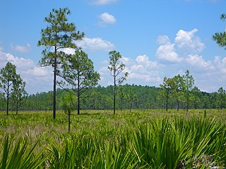
The Big Thicket is the name given to a somewhat imprecise region of a heavily forested area of Southeast Texas in the United States. This area represents a portion of the mixed pine-hardwood forests of the Southeast US. The National Park Service established the Big Thicket National Preserve (BTNP) within the region in 1974 and it is recognized as a biosphere reserve by UNESCO. Although the diversity of animals in the area is high, with over 500 vertebrates, it is the complex mosaic of ecosystems and plant diversity that is particularly remarkable. Biologists have identified at least eight, and up to eleven, ecosystems in the Big Thicket area. More than 160 species of trees and shrubs, 800 herbs and vines, and 340 types of grasses are known to occur in the Big Thicket, and estimates as high as over 1000 flowering plant species and 200 trees and shrubs have been made, plus ferns, carnivorous plants, and more. The Big Thicket has historically been the most dense forest region in what is now Texas.
Isoetes louisianensis, the Louisiana quillwort, is a small, grass-like aquatic plant of the family Isoetaceae. It is "one of the rarest quillworts in North America." It occurs in only five locations in St. Tammany and Washington Parishes of Louisiana and some spots in southern Mississippi. It is federally listed as an endangered species, partly due to its highly restricted range.

The Atlantic coastal pine barrens is a now rare temperate coniferous forest ecoregion of the Northeast United States distinguished by unique species and topographical features, generally nutrient-poor, often acidic soils and a pine tree distribution once controlled by frequent fires.

The Donald E. Davis Arboretum, in Auburn, Alabama, United States, is a public native plants museum, and botanical arboretum with educational facilities, event spaces, and a conservation program. Its grounds, covering 13.5 acres of Auburn University's campus, include cataloged living collections of associated tree and plant communities representative of Alabama's ecosystems, among which is mixed oak forest, carnivorous bog, and longleaf pine savanna. The living collections include more than 1,000 plant types, including 500 different plant species, with over 3,000 cataloged specimens. The Arboretum contains over a mile (2 km) of interwoven walking trails that meander through various southeastern biotopes.

The New England-Acadian forests are a temperate broadleaf and mixed forest ecoregion in North America that includes a variety of habitats on the hills, mountains and plateaus of New England and New York State in the Northeastern United States, and Quebec and the Maritime Provinces of Eastern Canada.

Big Sandy Creek is a stream in Texas, United States. It rises in Polk County before flowing approximately 40 miles (64 km) southeast into Hardin County where it merges with Kimball Creek, forming Village Creek. Long sections of the creek pass through the Big Thicket National Preserve. The 14,343 acres (58.04 km2) Big Sandy Creek unit is named after the stream. The creek also passes through the Alabama-Coushatta Reservation reservation east of Livingston.

Pine Island Bayou is a tributary of the Neches River located in southeast Texas. It runs about 55 miles from the northwest corner of Hardin County, Texas and flows in a southeastern direction through western Hardin County, turning east and defining the southern Hardin and Jefferson County boundary for about 20 miles until its confluence with the Neches River. Two significant tributaries of Pine Island Bayou are Mayhaw Creek and Little Pine Island Bayou. The lower ten miles of Pine Island Bayou and much of Little Pine Island Bayou are protected from development in the Big Thicket National Preserve. Excluding the last few miles north of Beaumont, the area is not densely populated, and some small towns include Sour Lake and Saratoga, the latter the birthplace of country singer George Jones.

Coniferous swamps are forested wetlands in which the dominant trees are lowland conifers such as northern white cedar. The soil in these swamp areas is typically saturated for most of the growing season and is occasionally inundated by seasonal storms or by winter snow melt.

The Middle Atlantic coastal forests are a temperate coniferous forest mixed with patches of evergreen broadleaved forests along the coast of the southeastern United States.

Lysimachia asperulifolia is a rare species of flowering plant in the Primulaceae known by the common name rough-leaved loosestrife and roughleaf yellow loosestrife. It is endemic to the Atlantic coastal plain in North Carolina and northern South Carolina in the United States, where there are 64 known populations. It is a federally listed endangered species of the United States.

Gaylussacia dumosa is a species of flowering plant in the heath family known by the common names dwarf huckleberry, bush huckleberry, and gopherberry. It is native to eastern North America from Newfoundland to Louisiana and Florida. It occurs along the coastal plain and in the mountains.

Eubotrys racemosa is a species of flowering plant in the heath family known by the common names fetterbush, swamp doghobble, and swamp sweetbells.

Smilax laurifolia is a species of flowering plant in the greenbrier family known by the common names laurel greenbrier, laurelleaf greenbrier, bamboo vine, and blaspheme vine. It is native to the southeastern United States, where it occurs along the Gulf and Atlantic coastal plains from Texas to New Jersey, the range extending inland to Arkansas, Oklahoma, and Tennessee. It also occurs in Cuba and the Bahamas.
A cypress dome is a type of freshwater forested wetland, or a swamp, found in the southeastern part of the United States. They are dominated by the Taxodium spp., either the bald cypress, or pond cypress. The name comes from the dome-like shape of treetops, formed by smaller trees growing on the edge where the water is shallow while taller trees grow at the center in deeper water. They usually appear as circular, but if the center is too deep, they form a “doughnut” shape when viewed from above. Cypress domes are characteristically small compared to other swamps, however they can occur at a range of sizes, dependent on the depth.

The Southeastern conifer forests are a temperate coniferous forest ecoregion of the southeastern United States. It is the largest conifer forest ecoregion east of the Mississippi River. It is also the southernmost instance of temperate coniferous forest within the Nearctic realm.
The southern coastal plain hydric hammock is a wetland hammock community found on the flat lowlands of the southern and outermost parts of the Atlantic Coastal Plain in the states of Georgia, Florida, and Alabama. These forests of evergreen and deciduous hardwood trees occur near the floodplains of spring-fed rivers with relatively constant flows, usually over limestone substrates. They are usually found on gentle slopes just above swamps, marshes or wet prairies. In places, they can form large areas of broad, shallow wetlands.

Turkey Creek is a stream in Texas, United States. It rises in Central Tyler county and flows 30 miles (48 km) before converging with Village Creek, east of Kountze, Hardin County. It passes through the 8,032-acre (3,250 ha) Turkey Creek Unit of the Big Thicket National Preserve on its way south.

