
Los Alamos National Laboratory is one of the sixteen research and development laboratories of the United States Department of Energy (DOE), located a short distance northwest of Santa Fe, New Mexico, in the American southwest. Best known for its central role in helping develop the first atomic bomb, LANL is one of the world's largest and most advanced scientific institutions.

White Rock is an unincorporated community and census-designated place (CDP) in Los Alamos County, New Mexico. It is one of two major population centers in the county; the other is Los Alamos. The population was 5,725 at the 2010 census. It is largely a bedroom community for employees of Los Alamos National Laboratory and their families. Access to White Rock from the town of Los Alamos and other cities and towns in New Mexico is via New Mexico State Road 4, which forms the northwestern boundary of the community. Administratively, White Rock is a neighborhood of Los Alamos; locals refer to Los Alamos as "the Townsite," or "the Hill".

Bandelier National Monument is a 33,677-acre (13,629 ha) United States National Monument near Los Alamos in Sandoval and Los Alamos counties, New Mexico. The monument preserves the homes and territory of the Ancestral Puebloans of a later era in the Southwest. Most of the pueblo structures date to two eras, dating between 1150 and 1600 AD.
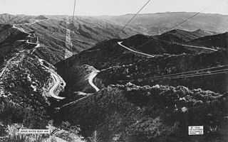
The Ridge Route, officially the Castaic–Tejon Route, was a two-lane highway between Los Angeles County and Kern County, California. Opened in 1915 and paved with concrete between 1917 and 1921, the road was the first paved highway directly linking the Los Angeles Basin with the San Joaquin Valley over the Tejon Pass and the rugged Sierra Pelona Mountains ridge south of Gorman. Much of the old road runs through the Angeles National Forest, and passes many historical landmarks, including the National Forest Inn, Reservoir Summit, Kelly's Half Way Inn, Tumble Inn, and Sandberg's Summit Hotel. North of the forest, the Ridge Route passed through Deadman's Curve before ending at Grapevine.
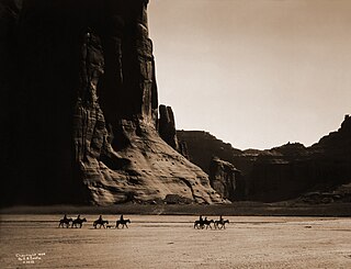
Canyon de Chelly National Monument was established on April 1, 1931, as a unit of the National Park Service. Located in northeastern Arizona, it is within the boundaries of the Navajo Nation and lies in the Four Corners region. Reflecting one of the longest continuously inhabited landscapes of North America, it preserves ruins of the indigenous tribes that lived in the area, from the Ancestral Puebloans to the Navajo. The monument covers 83,840 acres and encompasses the floors and rims of the three major canyons: de Chelly, del Muerto, and Monument. These canyons were cut by streams with headwaters in the Chuska Mountains just to the east of the monument. None of the land is federally owned. Canyon de Chelly is one of the most visited national monuments in the United States.
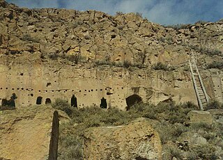
The Puye Cliff Dwellings are the ruins of an abandoned pueblo, located in Santa Clara Canyon on Santa Clara Pueblo land near Española, New Mexico. The site was declared a National Historic Landmark in 1966.

The Old Spanish Trail is a historical trade route that connected the northern New Mexico settlements of Santa Fe, New Mexico with those of Los Angeles, California and southern California. Approximately 700 mi (1,100 km) long, the trail ran through areas of high mountains, arid deserts, and deep canyons. It is considered one of the most arduous of all trade routes ever established in the United States. Explored, in part, by Spanish explorers as early as the late 16th century, the trail was extensively used by traders with pack trains from about 1830 until the mid-1850s.

This is a list of properties and districts in New Mexico that are on the National Register of Historic Places. There are more than 1,100 listings. Of these, 46 are National Historic Landmarks. There are listings in each of the state's 33 counties.

Lincoln National Forest is a unit of the U.S. Forest Service located in southern New Mexico. The Lincoln National Forest covers an extensive 1.1 million acres in southeastern New Mexico. Established by Presidential Proclamation in 1902 as the Lincoln Forest Reserve, the 1,103,897 acres (4,467.31 km2) forest begins near the Texas border and contains lands in parts of Chaves, Eddy, Lincoln, and Otero counties. The Lincoln National Forest is home to three major mountain ranges: Sacramento, Guadalupe and Capitan. The three Ranger Districts within the forest contain all or part of a total of four mountain ranges, and include a variety of different environmental areas, from desert to heavily forested mountains and sub-alpine grasslands. Clean air, water, and soil are necessary elements that the National Forests contribute to the environment. Established to balance conservation, resource management, and recreation, the lands of the Lincoln National Forest include important local timber resources, protected wilderness areas, and popular recreation and winter sports areas. The forest headquarters is located in Alamogordo, N.M. with local offices in Carlsbad, Cloudcroft, and Ruidoso.

The historic U.S. Route 66 ran east–west across the central part of the state of New Mexico, along the path now taken by Interstate 40 (I-40). However, until 1937, it took a longer route via Los Lunas, Albuquerque, and Santa Fe, now roughly New Mexico State Road 6 (NM 6), I-25, and US 84. Large portions of the old road parallel to I-40 have been designated NM 117, NM 118, NM 122, NM 124, NM 333, three separate loops of I-40 Business, and state-maintained frontage roads.

The Cerro Grande Fire was a disastrous forest fire in New Mexico, United States of America, that occurred in May 2000. The fire started as a controlled burn, and became uncontrolled owing to high winds and drought conditions. Over 400 families in the town of Los Alamos, New Mexico, lost their homes in the resulting 43,000-acre (170 km2) fire. Structures at Los Alamos National Laboratory were also destroyed or damaged, although without loss or destruction of any of the special nuclear material housed there. No loss of human life occurred. The US General Accounting Office estimated total damages at $1 billion.

Salmon Ruins is an ancient Chacoan and Pueblo site located in the northwest corner of New Mexico, USA. Salmon was constructed by migrants from Chaco Canyon around 1090 CE, with 275 to 300 original rooms spread across three stories, an elevated tower kiva in its central portion, and a great kiva in its plaza. Subsequent use by local Middle San Juan people resulted in extensive modifications to the original building, with the reuse of hundreds of rooms, division of many of the original large, Chacoan rooms into smaller rooms, and emplacement of more than 20 small kivas into pueblo rooms and plaza areas. The site was occupied by ancient Ancestral Puebloans until the 1280s, when much of the site was destroyed by fire and abandoned. The pueblo is situated on the north bank of the San Juan River, just to the west of the modern town of Bloomfield, New Mexico, and about 45 miles (72 km) north of Pueblo Bonito in Chaco Canyon. The site was built on the first alluvial terrace above the San Juan River floodplain.

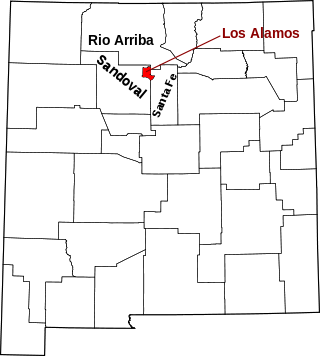
Los Alamos is a census-designated place in Los Alamos County, New Mexico, United States, that is recognized as one of the development and creation places of the atomic bomb—the primary objective of the Manhattan Project by Los Alamos National Laboratory during World War II. The town is located on four mesas of the Pajarito Plateau, and had a population of about 13,200 as of 2020. It is the county seat and one of two population centers in the county known as census-designated places (CDPs); the other is White Rock.
The RaLa Experiment, or RaLa, was a series of tests during and after the Manhattan Project designed to study the behavior of converging shock waves to achieve the spherical implosion necessary for compression of the plutonium pit of the nuclear weapon. The experiment used significant amounts of a short-lived radioisotope lanthanum-140, a potent source of gamma radiation; the RaLa is a contraction of Radioactive Lanthanum. The method was proposed by Robert Serber and developed by a team led by the Italian experimental physicist Bruno Rossi.

Cerro Grande is a 10,207-foot (3,111 m) summit on the rim of the Valles Caldera not far north of New Mexico State Road 4, the main highway through Los Alamos County. Like many mountains in the Jemez, Cerro Grande was mainly covered with coniferous forest, composed largely of ponderosa pine and aspen trees, with a characteristic rincon (meadow) on its slopes on and south of the summit.

The Las Conchas Fire was a large wildfire in the state of New Mexico, in the United States, in 2011. The fire started in Santa Fe National Forest and burned more than 150,000 acres, threatening Los Alamos National Laboratory and the town of Los Alamos. After five days of burning, it became the largest wildfire in New Mexico state history at the time. It was surpassed in 2012 by the much larger Whitewater-Baldy Complex Fire and in 2022 by the Calf Canyon/Hermits Peak Fire and the Black Fire making the Las Conchas Fire the fourth-largest fire in New Mexico's recorded history.

The Otowi Historic District is a 29-acre (0.12 km2) historic district in northern Santa Fe County, New Mexico, having four contributing buildings and three contributing structures including Otowi Suspension Bridge and was listed on the National Register of Historic Places in 1975.
This is a list of the National Register of Historic Places listings in Los Alamos County, New Mexico.
NAN Ranch, also known as Y Bar NAN Ranch, is a ranch in Faywood, New Mexico, that was added to the National Register of Historic Places in 1988. The property was developed as a ranch beginning in the late-1860s by John Brockman, who grew corn, alfalfa, and several types of fruit and bred cattle. Cattleman John T. McElroy purchased the ranch in 1927 and hired Trost & Trost to renovate and expand the ranch compound to become the NAN Ranch headquarters. The project included a new house, extensive landscaping, swimming pool, a slaughterhouse, powerhouse, and other residential and ranch buildings. It is historically significant due to its architecture and its role as a major 19th century ranch.
Arroyo Bayo is an 8-mile-long (13 km) perennial stream which flows northwest along Mount Hamilton Road east of Mt. Hamilton in the Diablo Range. It is part of the southern Alameda Creek watershed in Santa Clara County, California.
