
Bayport is a hamlet and census-designated place (CDP) in the Town of Islip, Suffolk County, New York, United States, on Long Island. The population was 8,609 at the 2020 census.

Bohemia is a hamlet in Suffolk County, New York, United States. The population was 9,852 at the 2020 census. It is situated along the South Shore of Long Island in the Town of Islip, approximately 50 miles from New York City.

Islip is a town in Suffolk County, New York, United States, on the South Shore of Long Island. The population was 335,543 at the 2010 census, making it the fourth most populous city or town in the New York metropolitan area.

Floyd Bennett Field is an airfield in the Marine Park neighborhood of southeast Brooklyn in New York City, along the shore of Jamaica Bay. The airport originally hosted commercial and general aviation traffic before being used as a naval air station. Floyd Bennett Field is currently part of the Gateway National Recreation Area's Jamaica Bay Unit, and is managed by the National Park Service (NPS). While no longer used as an operational commercial, military, or general aviation airfield, a section is still used as a helicopter base by the New York City Police Department (NYPD), and one runway is reserved for hobbyists flying radio-controlled aircraft.

Peebles Island State Park is a 190-acre (0.77 km2) state park located at the confluence of the Mohawk and Hudson rivers in New York. A majority of the park is located in Saratoga County, with a smaller portion located in Albany County.

Roosevelt Field is a former airport, located in Westbury, Long Island, New York. Originally called the Hempstead Plains Aerodrome, or sometimes Hempstead Plains field or the Garden City Aerodrome, it was a training field for the Air Service, United States Army during World War I.
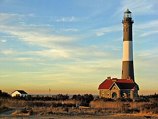
The Fire Island Lighthouse is a visible landmark on the Great South Bay, in southern Suffolk County, New York on the western end of Fire Island, a barrier island off the southern coast of Long Island. The lighthouse is located within Fire Island National Seashore and just to the east of Robert Moses State Park. It is part of the Fire Island Light Station which contains the light, keepers quarters, the lens building containing the original first-order Fresnel lens, and a boat house.

Bowman Field is a public airport five miles (8.0 km) southeast of downtown Louisville, in Jefferson County, Kentucky. The airport covers 426 acres (172 ha) and has two runways. The FAA calls it a reliever airport for nearby Louisville Muhammad Ali International Airport.

Cos Cob is a neighborhood and census-designated place in the town of Greenwich, Connecticut. It is located on the Connecticut shoreline in southern Fairfield County. It had a population of 6,873 at the 2020 census.

Mitchel Air Force Base, also known as Mitchel Field, was a United States Air Force base located on the Hempstead Plains of Long Island, New York, United States. Established in 1918 as Hazelhurst Aviation Field #2, the facility was renamed later that year as Mitchel Field in honor of former New York City Mayor John Purroy Mitchel, who was killed while training for the Air Service in Louisiana.

Plum Island Airport, in Newburyport, Massachusetts, is a privately owned, public-use airport owned by Historic New England and operated by Plum Island Aerodrome, Inc., a non-profit corporation. It has two runways, averages 54 flights per week, and has approximately 8 based aircraft.

Miller Field was a United States Army facility in the neighborhood of New Dorp, Staten Island, New York. It was founded in November 1919 and completed in 1921.

Caumsett State Historic Park Preserve is a state park on Lloyd Neck, a peninsula extending into the Long Island Sound, in the Village of Lloyd Harbor, New York. It is operated by the New York State Office of Parks, Recreation and Historic Preservation.

Ashokan Bridge is a wooden covered bridge over Esopus Creek on the grounds of the Ashokan Center, in Ulster County. It was built in 1885, and is a single span, gable roofed, covered timber bridge. It measures 72 feet, 6 inches, long and 16 feet, 4 inches, wide. It was originally located at Turnwood and moved to its present location in 1939. It is situated in the Ashokan Center, which was formerly the Ashokan Field Campus of the State University of New York at New Paltz.

Nearly every major type of transportation serves Long Island, including three major airports, railroads and subways, and several major highways. The New York City Subway only serves the New York City boroughs of Brooklyn and Queens. There are historic and modern bridges, recreational and commuter trails, and ferries, that connect the boroughs of Queens and Brooklyn to Manhattan, the south shore with Fire Island and Long Island's north shore and east end with the state of Connecticut.
Davis Field may refer to:

The Andrew Gildersleeve Octagonal Building, also known as Mattituck, the Octagon House and Mattituck Octagon House, is an historic octagon house located at Main Road and Love Lane in Mattituck, New York. It was built in 1854 by Andrew Gildersleeve, a master carpenter, who used it for his family home as well as for a store.

John Ellis Roosevelt Estate, also known as Meadow Croft, is a historic estate located at Sayville in Suffolk County, New York.

The Erie Canalway National Heritage Corridor is a National Heritage Area in New York State.

Old Bar Airfield is a heritage-listed airfield located off Old Bar Road at Old Bar, Mid-Coast Council, New South Wales, Australia. It was built from in 1925 by George Bunyan and family. It is also known as Old Bar Airstrip and Old Bar Aerodrome. It was added to the New South Wales State Heritage Register on 25 February 2000.


