
Swissair Flight 111 (SR111/SWR111) was a scheduled international passenger flight from John F. Kennedy International Airport in New York City, United States, to Cointrin Airport in Geneva, Switzerland. The flight was also a codeshare flight with Delta Air Lines. On 2 September 1998, the McDonnell Douglas MD-11 performing this flight, registration HB-IWF, crashed into the Atlantic Ocean southwest of Halifax Stanfield International Airport at the entrance to St. Margarets Bay, Nova Scotia. The crash site was 8 kilometres from shore, roughly equidistant from the small fishing and tourist communities of Peggy's Cove and Bayswater. All 229 passengers and crew on board the MD-11 were killed, making the crash the deadliest accident in the history of Swissair and the deadliest accident involving the McDonnell Douglas MD-11. It is also the second-deadliest aviation accident to occur in Canada, behind Arrow Air Flight 1285R.

Peggy's Cove is a small rural community located on the eastern shore of St. Margarets Bay in the Halifax Regional Municipality, which is the site of Peggys Cove Lighthouse.
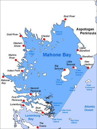
Mahone Bay is a bay on the Atlantic coast of Nova Scotia, Canada along the eastern end of Lunenburg County. The bay has many islands, and is a popular sailing area. Since 2003 the Mahone Islands Conservation Association has been working to protect the natural environment of the bay. The bay and its islands contain a variety of habitats including forests, rocky shores, beaches, wetlands, and mudflats. Wildlife in the area include black guillemots, eagles, osprey, leach's storm petrels, puffins, razorbills, and great blue herons.

St. Margarets Bay is a bay located on the Atlantic coast of Nova Scotia, Canada on the border of Halifax County and Lunenburg County.
Chester—St. Margaret's is a provincial electoral district in Nova Scotia, Canada, that elects one member of the Nova Scotia House of Assembly. It is located on the South Shore.
The Aspotogan Peninsula is a peninsula in the eastern part of Lunenburg County, Nova Scotia, separating St. Margarets Bay in the east from Mahone Bay in the west. The peninsula was originally settled by second generation French immigrants on the east side and by second generation German immigrants on the west side. Traditionally fishing was a major industry for communities throughout the peninsula, however other primary industries such as farming and forestry were historically important as well. Shipping and shipbuilding were secondary and tertiary industries that also came into prominence during the 19th and early 20th centuries.
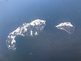
Big Tancook Island is the largest of many islands in Mahone Bay, Nova Scotia. It measures approximately 4 km (2.5 mi) by 1.6 km (1.0 mi) forming roughly a "C" shape. Its area is 550 acres (2.2 km2) and has a rocky shoreline with open fields and softwood forest dotted by ponds, residential properties and fish stores. It is separated from nearby Little Tancook Island to the east by a 1 km (0.6 mi) wide strait called "The Chops". Big Tancook Island is approximately 4 km (2.5 mi) from Sandy Cove Point on the Aspotogan Peninsula - the nearest point on the mainland. Wildlife populations are limited to deer, muskrats, snakes, and pheasants, and a great variety of birds.

The Eastern Shore is a region of the Canadian province of Nova Scotia. It is the Atlantic coast running northeast from Halifax Harbour to the eastern end of the peninsula at the Strait of Canso.

The Diocese of Nova Scotia and Prince Edward Island is a diocese of the Ecclesiastical Province of Canada of the Anglican Church of Canada. It encompasses the provinces of Nova Scotia and Prince Edward Island and has two cathedrals: All Saints' in Halifax and St. Peter's in Charlottetown. Its de facto see city is Halifax, and its roughly 24 400 Anglicans distributed in 239 congregations are served by approximately 153 clergy and 330 lay readers according to the last available data. According to the 2001 census, 120,315 Nova Scotians identified themselves as Anglicans, while 6525 Prince Edward Islanders did the same.

The South Shore Regional Centre for Education (SSRCE) is the public school board responsible for the administration of elementary, junior high, and high school education in Lunenburg County and Queens County in Nova Scotia, Canada. The South Shore Regional Centre for Education was established on April 1, 2018 by the Nova Scotia Education Reform Act. It replaced the South Shore Regional School Board which was created August 1, 2004 by an Act of the provincial legislature.
The Lighthouse Route is a scenic roadway in the Canadian province of Nova Scotia. It follows the province's South Shore for 585 km (364 mi) from Halifax to Yarmouth.
Route 329 is a collector road in the Canadian province of Nova Scotia.
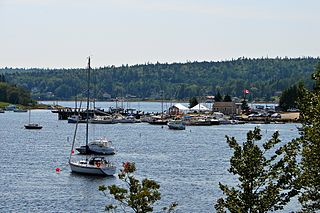
Hubbards is an unincorporated Canadian rural community on the South Shore of Nova Scotia.

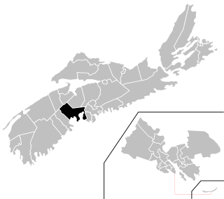
The Municipality of the District of Chester is a Nova Scotia district municipality occupying the northeastern half of Lunenburg County, Canada.

Nova Scotia is a province located in Eastern Canada fronting the Atlantic Ocean. One of the Maritime Provinces, Nova Scotia's geography is complex, despite its relatively small size in comparison to other Canadian provinces.
Indian Harbour is a small fishing community of the Halifax Regional Municipality in the Canadian province of Nova Scotia on the Chebucto Peninsula. It is located between the communities of Peggy's Cove and Hackett's Cove.
Blandford is a community in the Canadian province of Nova Scotia, located in the Chester Municipal District on the Aspotogan Peninsula on the Lighthouse Route. Blandford originally included the present day communities of New Harbour, Upper Blandford, and Deep Cove.
Mill Cove is a community in the Canadian province of Nova Scotia, located in the Chester Municipal District on the Aspotogan Peninsula on the Lighthouse Route. The community was home to CFS Mill Cove from 1967 til the 1990s.
Southwest Cove is a Canadian rural community located in Lunenburg County, Nova Scotia.


