
The Philippine Sea is a marginal sea of the Western Pacific Ocean east of the Philippine Archipelago and the largest sea in the world, occupying an estimated surface area of 5 million square kilometers. The Philippine Sea Plate forms the floor of the sea. Its western border is the first island chain to the west, comprising the Ryukyu Islands in the northwest and Taiwan in the west. Its southwestern border comprises the Philippine islands of Luzon, Catanduanes, Samar, Leyte, and Mindanao. Its northern border comprises the Japanese islands of Honshu, Shikoku and Kyūshū. Its eastern border is the second island chain to the east, comprising the Bonin Islands and Iwo Jima in the northeast, the Mariana Islands in the due east, and Halmahera, Palau, Yap and Ulithi in the southeast. Its southern border is Indonesia's Morotai Island.

Inhassoro is a small fishing port in Inhassoro District of Inhambane Province in Mozambique. The town has 11,297 inhabitants and is located on the Indian Ocean coast along the EN1 highway.

The Bazaruto Archipelago is a group of six islands in Mozambique, near the mainland city of Vilankulo. It comprises the islands of Bazaruto, Benguerra, Magaruque, Santa Carolina and Bangué.

Bazaruto is a barrier island in the Bazaruto Archipelago of southern Mozambique. The largest island of the archipelago, Bazaruto sits near the eastern rim of the African continental shelf, sheltering the mainland coast on the other side of Bazaruto Bay. Formed during the Pleistocene, Bazaruto's sand dunes along its eastern shore are among the tallest in the world, reaching heights up to 90 m (300 ft). Besides the dune system, the island is dotted with grasslands, salt marshes, mangrove swamps, and patches of freshwater wetland. It harbors a variety of wildlife, including blue monkeys, harnessed bushbuck, and red forest duiker. The waters around the island are a vital refuge for dugongs and sea turtles.

The hawksbill sea turtle is a critically endangered sea turtle belonging to the family Cheloniidae. It is the only extant species in the genus Eretmochelys. The species has a global distribution that is largely limited to tropical and subtropical marine and estuary ecosystems.

The East African mangroves are a mangrove ecoregion consisting of swamps along the Indian Ocean coast of East Africa in Mozambique, Tanzania, Kenya and southern Somalia.

Madagascar mangroves are a coastal ecoregion in the mangrove forest biome found on the west coast of Madagascar. They are included in the WWF's Global 200 list of most outstanding ecoregions.
The Primeiras and Segundas Archipelago is a chain of 10 sparsely inhabited barrier islands and two coral reef complexes situated in the Indian Ocean off the coast of the Zambezia Province of Mozambique. The islands lie in two groups along the western side of the Mozambique Channel with the Segundas Islands located near the coastal city of Angoche.

The Menai Bay Conservation Area (MBCA) is located in Menai Bay, Zanzibar Tanzania. At 470 square kilometres (180 sq mi), it is Zanzibar's largest marine protected area. It was officially established as a conservation area in August 1997 in the traditional fishing area, known as Unguja Island, covering the tropical marine environment comprising extensive coral reefs, tropical fish, sea grasses, and mangrove forests. In addition to controlling illegal fishing, MBCA's alternative initiatives have included bee keeping, mangrove replanting, tree nurseries and tourism. The management of the MBCA falls upon the Fisheries Department and the bay's local villages. It is rated by the IUCN as Category VI Managed Resource Protected Area.

The Lampi Island Marine National Park is a marine national park in Myanmar covering 79.09 sq mi (204.8 km2). It was established in 1996. It encompasses Lanbi Island and several smaller islands in the Mergui Archipelago, comprising coral reefs, seagrass beds, mangroves, sand dunes and tropical evergreen forest up to an elevation of 1,493 ft (455 m). The national park is an Important Bird Area and one of the ASEAN Heritage Parks. The characteristics of the Marine National Park are the tropical evergreen rainforest, the vast coral reef systems that protect a wide range of aquatic ecosystems, and significant biodiversity in this area. Access is restricted to daytime visits.

The Chagos Marine Protected Area, located in the central Indian Ocean in the British Indian Ocean Territory of the United Kingdom, is one of the world's largest officially designated marine protected areas, and one of the largest protected areas of any type on Earth. It was established by the British government on 1 April 2010 as a massive, contiguous, marine reserve, it encompasses 640,000 square kilometres (250,000 sq mi) of ocean waters, including roughly 70 small islands and seven atolls of the Chagos Archipelago.
The St. Croix East End Marine Park (STXEEMP) was established to "protect territorially significant marine resources, and promote sustainability of marine ecosystems, including coral reefs, sea grass beds, wildlife habitats and other resources, and to conserve and preserve significant natural areas for the use and benefit of future generations." It is the U.S. Virgin Islands’ first territorially designated and managed marine protected area (MPA).
Nosy Ve-Androka National Park is a Protected Marine Area located in the southwestern part of Madagascar, south of Tulear, and 40 km south of the tourist village of Anakao. It lies between latitudes 25 ° 29/25 ° 09 South and longitudes 44 ° 50/45 ° 06 East and covers an area of 92080 ha. It is composed of Core Areas totalling 28,820 ha and Buffer Zones totalling 63,260 ha. The park is made up of eight parcels in two clusters, with part found along the coast adjacent to Tsimanampetsotsa National Park. It includes sections of the rich coral reef system of South West Madagascar in the Mozambique Channel, recognized as the third largest reef system in the world. Diversity of habitats include fringing reefs, barrier reefs, coral reef beds, seagrass area, open sea, rocky coast and sandy beaches. The Nosy Ve-Androka National Park contains about 140 species of coral and 240 species of fish. There are also rare species such as Coelacanths, marine turtle species, dugongs, dolphins and whales and sandy beaches that are used by nesting sea turtles.
The East African coral coast is a marine ecoregion along the eastern coast of Africa. It extends along the coasts of Kenya, Tanzania, and northern Mozambique, from Lamu in Kenya to Angoche in Mozambique. It adjoins the Northern Monsoon Current Coast ecoregion to the north, and the Bight of Sofala/Swamp Coast ecoregion to the south.

Delagoa is a marine ecoregion along the eastern coast of Africa. It extends along the coast of Mozambique and South Africa from the Bazaruto Archipelago to Lake St. Lucia in South Africa in South Africa's Kwazulu-Natal province. It adjoins the Bight of Sofala/Swamp Coast ecoregion to the north, and the Natal ecoregion to the south. It has Africa's southernmost tropical coral reefs and mangrove forests. It is the southernmost Indo-Pacific ecoregion, marking the transition from the tropical Indo-Pacific to Temperate Southern Africa.

The Mayotte Marine Natural Park is a marine park surrounding Mayotte, a French overseas region. Mayotte is part of the Comoro Islands archipelago, which lies within the Mozambique Channel in the western Indian Ocean. Established in 2010, the park covers the entirety of Mayotte's territorial waters and exclusive economic zone. It is contiguous with the Glorioso Islands Marine Natural Park, which was established two years later.
The Marine Megafauna Foundation (MMF) is a marine biology research and conservation nonprofit known for discovering, researching, and protecting large marine animals including whale sharks, manta rays, sea turtles, whales, and dugongs.
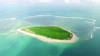
Ilha do Fogo, or Fire Island, is a remote, 3.5 km circumference island off the Zambezia Province coastline in northern Mozambique. It forms part of the Primeiras and Segundas Archipelago, within Africa's most extensive coastal marine protected area. The private island is encircled by coral-rich reefs on the island's south side and seagrasses on the north. It has 150 km of unexplored reef, with abundant and diverse marine life.

Bangué is a small sandy barrier island in the Bazaruto Archipelago of southern Mozambique, situated between Magaruque Island and the São Sebastião Peninsula to the south. Formed through wave action later than the other islands of the archipelago, it is a largely barren dune island with limited vegetation and no permanent inhabitants. It is occasionally visited by local fishermen and various seabirds. The islet is part of Bazaruto Archipelago National Park, and its surrounding waters form a vital habitat for dugong and sea turtles.


