
Kandahar or Qandahar is a city in Afghanistan, located in the south of the country on the Arghandab River, at an elevation of 1,010 m (3,310 ft). It is Afghanistan's second largest city after Kabul, with a population of about 614,118. It is the capital of Kandahar Province and also the center of the larger cultural region called Loy Kandahar. In 1709, Mirwais Hotak made the region an independent kingdom and turned Kandahar into the capital of the Hotak dynasty. In 1747, Ahmad Shah Durrani, founder of the Durrani dynasty, made Kandahar the capital of the Afghan Empire.

The Geography of Pakistan is a profound blend of landscapes varying from plains to deserts, forests, and plateaus ranging from the coastal areas of the Arabian Sea in the south to the mountains of the Karakoram, Hindukush, Himalayas ranges in the north. Pakistan geologically overlaps both with the Indian and the Eurasian tectonic plates where its Sindh and Punjab provinces lie on the north-western corner of the Indian plate while Balochistan and most of the Khyber Pakhtunkhwa lie within the Eurasian plate which mainly comprises the Iranian Plateau. Gilgit-Baltistan and Azad Kashmir lie along the edge of the Indian plate and are prone to violent earthquakes where the two tectonic plates collide.

Pashtūnistān is the geographic historical region inhabited by the indigenous Pashtun people of modern-day Afghanistan and Pakistan, wherein Pashtun culture, language, and national identity have been based. Alternative names historically used for the region include "Pashtūnkhwā" (پښتونخوا) and "Afghānistān" (افغانستان), since at least the 3rd century CE onward. Pashtunistan borders Iran to the west, Persian and Turkic-speaking areas of Turkestan region to the north, Kashmir to the northeast, Punjab to the east, and Balochistan to the south.
Hazārajāt or Hazāristān (هزارستان) is a mountainous region in the central highlands of Afghanistan, among the Koh-i-Baba mountains in the western extremities of the Hindu Kush. It is the homeland of the Hazara people who make up the majority of its population. "Hazārajāt denotes an ethnic and religious zone." Hazarajat is primarily made up of the provinces of Bamyan, Daykundi, Ghor and parts of Ghazni, Urozgan, Parwan and Maidan Wardak. The most populous towns in Hazarajat are Bamyan, Yakawlang (Bamyan), Nili (Daykundi), Lal wa Sarjangal (Ghor), Sang-e-Masha (Ghazni), Gizab (Urozgan) and Behsud. The Kabul, Farah, Hari, Murghab, Balkh and Kunduz rivers originate from Hazarajat.

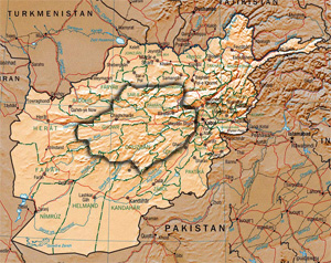
The Durand Line is the international 2,670-kilometre (1,660 mi) land border between Afghanistan and Pakistan in South-Central Asia. It was originally established in 1893 as the international border between British India and Emirate of Afghanistan by Mortimer Durand, a British diplomat of the Indian Civil Service, and Abdur Rahman Khan, the Afghan Emir, to fix the limit of their respective spheres of influence and improve diplomatic relations and trade.

Khorasan, also called Traxiane during Hellenistic and Parthian times, is a province in northeastern Iran but historically referred to a much larger area, comprising the east and the northeast of the Persian Empire. The name Khorāsān is Persian and means "where the sun arrives from". The name was first given to the eastern province of Persia during the Sasanian Empire and was used from the late middle ages in distinction to neighbouring Transoxiana.
Baghlan is one of the thirty-four provinces of Afghanistan. It is in the north of the country. As of 2013, the province has a population of about 910,700.

Ghazni is one of the 34 provinces of Afghanistan, located in eastern Afghanistan. The province contains 19 districts, encompassing over a thousand villages and roughly 1.3 million people, making it the 5th most populous province. The city of Ghazni serves as the capital. It lies on the important Kabul–Kandahar Highway, and has historically functioned as an important trade center. The Ghazni Airport is located next to the city of Ghazni and provides limited domestic flights to Afghanistan's capital, Kabul.
Nimruz or Nimroz is one of the 34 provinces of Afghanistan, located in the southwestern part of the country. It lays to the east of the Sistan and Baluchestan Province of Iran and north of Balochistan, Pakistan, also bordering the Afghan provinces of Farah and Helmand. The province contains five districts, encompassing about 649 villages, and roughly 156,600 settled people, the second least populous province. The city of Zaranj serves as the provincial capital and Zaranj Airport, which is located by that city, serves as a domestic airport for the province.

The Grand Trunk Road formerly known as Uttarapath, Sarak-e-Azam, Badshahi Sarak, Sarak-e-Sher Shah is one of Asia's oldest and longest major roads. For at least 2,500 years, it has linked Central Asia to the Indian subcontinent. It runs roughly, 3,670 km (2,280 mi) from Cox's Bazar, Bangladesh west to Kabul, Afghanistan, passing through Chittagong and Dhaka in Bangladesh, Kolkata, Allahabad (Prayagraj), Delhi, and Amritsar in India, and Lahore, Rawalpindi, and Peshawar in Pakistan.

Khorāsān, sometimes called Greater Khorasan, is a historical region which formed the northeast province of Greater Iran. The name signifies "the Land of the Sun" or "the Eastern Province".

The Panjdeh incident of 1885 was a diplomatic crisis between the British Empire and the Russian Empire caused by the Russian expansion south-eastwards towards the Emirate of Afghanistan and the British Raj (India). After nearly completing the Russian conquest of Central Asia the Russians captured an Afghan border fort. Seeing a threat to India, Britain came close to threatening war but both sides backed down and the matter was settled by diplomacy. The effect was to stop further Russian expansion in Asia, except for the Pamir Mountains and to define the north-western border of Afghanistan.

Fārsīwān is a designation for Persian speakers in Afghanistan, with diaspora in Iran and elsewhere abroad. More specifically, it is used to refer to a distinct group of farmers in Afghanistan and urban dwellers. They are often mistakenly referred to as Tajiks. The term excludes the Hazāra and Aymāq tribes who also speak dialects of Persian. In Afghanistan, the Farsiwan are found predominantly in Herat and Farah provinces. They are roughly the same as the Persians of Eastern Iran. Although the term was originally coined with Persian language's lexical root (Pārsībān), the suffix has been transformed into a Pashto form (-wān) and is usually utilized by the Pashtuns to designate both, the Tajiks and the Farsiwans.

Bala murghab is a district situated in the northeast of Badghis Province, Afghanistan. The district capital is Bala Murghab city which is located along the Murghab River. Bala Murghab is surrounded by some other important districts such as Ab Kamari, Muqur, Jawand, and Qadis.

Khwahan /(Tajik: Хоҳон) is the name of a district, a fort and a town in Badakhshan Province in north-eastern Afghanistan. They are all located on the left bank of the Panj River, sub-regions of Darwaz.
Shīnḍanḍ District is one of the 16 districts of Herat Province, in western Afghanistan, and is situated in the southern part of that province. It borders Adraskan District to the north, Ghor Province to the east and Farah Province to the south and west. The population was 173,800. The district center is the town of Shindand, which boasts a very active market area. Shindand Air Base is located near the town. The main Herat-Kandahar road passes through the district. The Zerkoh Valley is in the district.
Chakaran is a village in Badakhshan Province in north-eastern Afghanistan, on the right bank of the Warduj River, about 18 miles southeast of Khairabad. It had previously been the main village of the Warduj area, and where the arbab and aksakal resided. A stream runs from a large ravine, past this village, and into the Warduj River. Around 1900, the village had been a large one, with roughly 80 houses, which cultivated a variety of fruit trees, as well as melons and watermelons.
Ishkashim Persian: اشکاشم, also transliterated Ishkashem or Eshkashem, is a town in Badakhshan Province in north-eastern Afghanistan, the capital of Ishkashim District. It lies on the Panj River, at a point where its direction turns sharply north. Ishkashim lies opposite a town of the same name in Tajikistan, although the Tajik town is normally transliterated Ishkoshim following Tajik practice. A bridge linking the two towns was reconstructed in 2006.
Fotur is a village in Badakhshan Province in north-eastern Afghanistan.

The suffix -stan is Persian for "place of" or "country". It appears in the names of many regions in Iran, Afghanistan, and Central and South Asia, as well as in the Caucasus and Russia.

