Acklington Park is a former civil parish, now in the parish of Acklington, Northumberland, England. It was the birthplace of John Rushworth who achieved fame in both England and during the formation of the United States of America for compiling a series of works called Historical Collections covering the English Civil Wars throughout the 17th century. His writings became a part of the library of Thomas Jefferson and the second Library of Congress. In 1951 the parish had a population of 33.
Birling is a small settlement and former civil parish, now in the parish of Warkworth, in the county of Northumberland, England. It is situated immediately to the north of the village of Warkworth on the A1068, separated from Warkworth by the River Coquet. There are facilities for static and touring caravans at Birling. To the east are Warkworth Golf Club, Birling Links and beach. In 1951 the parish had a population of 81.

Bolton is a small village and former civil parish, now in the parish of Hedgeley, in the county of Northumberland, England. It is situated on the north side of the River Aln, about two miles (3 km) east by north from Whittingham, and 5+1⁄2 miles west from Alnwick. It has a chapel and a small number of residential properties.
Brandon is a village and former civil parish, now in the parish of Ingram, in Northumberland, in England. It is about 9 miles (14 km) north-west of Alnwick and 8 miles (13 km) south of Wooler in the Breamish Valley, just off the A697 north of Powburn. In 1951 the parish had a population of 58.
Branton is a village and former civil parish, now in the parish of Ingram, in Northumberland, England. It is about 9 miles (14 km) west of Alnwick. In 1951 the parish had a population of 50.
Brunton is a village and former civil parish, now in the parish of Newton-by-the-Sea, in the county of Northumberland, England. It is about 7 miles (11 km) north of Alnwick, a short distance inland from the North Sea coast. In 1951 the parish had a population of 35.
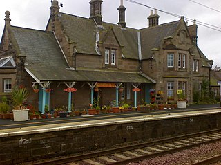
Chathill is a hamlet and former civil parish, now in the parish of Ellingham, in Northumberland, England. It is about 9 miles (14 km) north of Alnwick and 3 miles (5 km) inland from the North Sea coast. It is served by Chathill railway station. It is on the main road serving Seahouses and the northern coast. In 1951 the parish had a population of 59.
Bassington is a former civil parish, now in the parish of Eglingham, in the county of Northumberland, England. It is located about 3 miles (5 km) northwest of Alnwick. Bassington is traversed by the River Aln. In 1951 the parish had a population of 2.

Eglingham is a village in Northumberland, England, situated about 7 miles (11 km) north-west of Alnwick and 10 miles (16 km) from Wooler. It lies in the sheltered valley of the Eglingham Burn, a tributary of the River Aln, about 100 metres (330 ft) above sea level, in a rural conservation area set amongst rolling countryside, within 5 miles (8 km) of the Cheviot Hills. The village is surrounded by mainly arable farmland, moorland and woodland, including an arboretum and some commercial forestry.
Swarland is a small modern village and former civil parish, now in the parish of Newton-on-the-Moor and Swarland, in the county of Northumberland, England, situated about 7 miles (11 km) south of the market town of Alnwick and 25 miles (40 km) north of the city of Newcastle upon Tyne. In 1951 the parish had a population of 368.
Broxfield is a hamlet and former civil parish, now in the parish of Rennington, in the county of Northumberland, England, off the B1340. In 1951 the parish had a population of 18.
Unthank is a hamlet and former civil parish, now in the parish of Alnham in Northumberland, England. In 1951 the parish had a population of 11.

Rock is a village and former civil parish, now in the parish of Rennington, in Northumberland, England about 5 miles (8 km) north of Alnwick. In 1951 the parish had a population of 162.

Howtel is a village and former civil parish, now in the parish of Kilham, in Northumberland, England about 8 miles (13 km) northwest of Wooler. The name Howtel is thought to mean Low Ground with a Holt or Wood. In 1951 the parish had a population of 75.
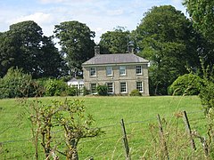
North Charlton is a hamlet and former civil parish, now in the parish of Eglingham in Northumberland, in England. It is situated between Alnwick and Berwick-upon-Tweed, on the A1. In 1951 the civil parish had a population of 90. On 1 April 1955 the civil parish was merged into Eglingham. A notable country house is Charlton Hall, Northumberland which is now a wedding venue.

South Charlton is a small village and former civil parish, now in the parish of Eglingham, in the English county of Northumberland, five miles (8 km) north-west of Alnwick. In 1951 the parish had a population of 82.

Hepburn is a hamlet and former civil parish, now in the civil parish of Chillingham in the county of Northumberland, England. The civil parish was merged into Chillingham in 1935. In 1951 the civil parish had a population of 43.

Scrainwood is a hamlet and former civil parish 20 miles (32 km) from Morpeth, now in the parish of Alnham, in the county of Northumberland, England. In 1951 the parish had a population of 16. Scrainwood Estate is 1048 acres and has a shoot that specializes in partridges.

Roddam is a village and civil parish about 24 miles from Morpeth, in the county of Northumberland, England. In 2001 the parish had a population of 77. The parish touches Bewick, Hedgeley, Ilderton, Ingram and Lilburn. It lies near the foot of the Cheviot Hills.