Five Rivers is a tributary of the Alsea River in the U.S. state of Oregon, in Lane, Lincoln, Benton counties. The name Five Rivers refers to the relative importance to the stream of five of its tributaries: Alder, Cougar, Buck, Crab, and Cherry creeks.

Mosby Creek is a 21-mile (34 km) tributary of the Row River in Lane County, in the U.S. state of Oregon. It begins at the confluence of the east and west forks of the creek near the Calapooia Divide and the border with Douglas County. From its source it flows generally north-northwest to meet the river slightly east of Cottage Grove and about 4 miles (6 km) from the larger stream's confluence with the Coast Fork Willamette River.

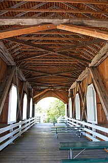
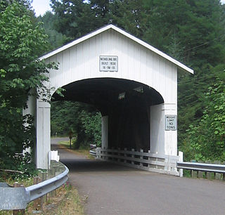
The Horse Creek Bridge was a covered bridge near the unincorporated community of McKenzie Bridge in Lane County in the U.S. state of Oregon. Built in 1930, the structure, 105 feet (32 m) long, carried Horse Creek Road over Horse Creek. The creek is a tributary of the McKenzie River.

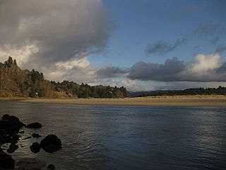
Drift Creek is a tributary, about 18 miles (29 km) long, of Siletz Bay in the U.S. state of Oregon. The creek begins near Stott Mountain in the Central Oregon Coast Range in Lincoln County and follows a winding course generally west through the Siuslaw National Forest to enter the bay south of Lincoln City on the Pacific Ocean. It passes under U.S. Route 101 just before reaching the bay.

Coyote Creek is a tributary of the Long Tom River via Fern Ridge Reservoir in Lane County in the U.S. state of Oregon. Beginning in hills south of Eugene, it meanders generally north through Gillespie Corners and Crow before entering the reservoir east of Veneta.
Deadwood Creek is a tributary of Lake Creek in the Siuslaw River basin in Lane County in the U.S. state of Oregon. Beginning near Taylor Butte in the Central Oregon Coast Range, it meanders generally southwest through the Siuslaw National Forest to meet the larger creek at the rural community of Deadwood. This is 5 miles (8 km) from Lake Creek's confluence with the river near Swisshome and 34 miles (55 km) by water from the Siuslaw River's mouth on the Pacific Ocean at Florence.

Lost Creek is a tributary of the south fork of Little Butte Creek in Jackson County in the U.S. state of Oregon. Flowing north from near Lost Lake east of Medford, it enters the larger stream about 4 miles (6 km) upstream of the rural community of Lake Creek and about 20 miles (32 km) from the confluence of Little Butte Creek with the Rogue River. The only named tributary of Lost Creek is Coon Creek, which enters from the left.

Myrtle Creek is a short tributary of the South Umpqua River in Douglas County in the U.S. state of Oregon. Its main stem, formed by the confluence of two forks just south of the city of Myrtle Creek, is only about 1 mile (1.6 km) long. Its only named tributaries are the two forks, North Myrtle Creek and South Myrtle Creek, each of which is much longer than the main stem.
Sandy Creek is a tributary of the Middle Fork Coquille River in the U.S. state of Oregon. It begins near Scott Mountain in the Southern Oregon Coast Range and flows southwest to meet the river near the rural community of Remote. The creek passes under Oregon Route 42 and enters the river about 16 miles (26 km) from its mouth on the South Fork Coquille River near Myrtle Point. The creek's only named tributary is Fetter Creek, which enters from the right slightly upstream of Remote.
The Middle Fork Coquille River is a tributary, about 40 miles (64 km) long, of the South Fork Coquille River in the U.S. state of Oregon. It begins near Camas Mountain in Douglas County in the Southern Oregon Coast Range. It flows generally south, bypassing the community of Camas Valley while passing through the valley of the same name, then curves west and north to Remote in Coos County. The Middle Fork then flows generally west, passes by the small community of Bridge, and meets the South Fork near Myrtle Point. The confluence with the South Fork is 41 miles (66 km) by water to where the main stem of the Coquille River enters the Pacific Ocean at Bandon.
Ritner Creek is a tributary of the Luckiamute River in Polk County in the U.S. state of Oregon. The creek begins near Bald Mountain in the Central Oregon Coast Range and flows generally southeast to meet the Luckiamute southwest of Pedee and north of Kings Valley. The confluence is 31 miles (50 km) upstream of the Luckiamute's mouth on the Willamette River. Named tributaries of Ritner Creek from source to mouth are Sheythe, Love, Clayton, and Kinsey creeks.

Rocky Creek is a short coastal stream in Lincoln County in the U.S. state of Oregon. It begins near the western extremities of the Central Oregon Coast Range and flows generally west to the ocean south of Depot Bay and north of Otter Rock. It has no named tributaries.
Mill Creek is a tributary of the Mohawk River in Lane County in the U.S. state of Oregon. It begins in the foothills of the Cascade Range northeast of Springfield and flows generally west through Wendling to meet the river near Marcola. The confluence is about 13 river miles (21 km) from the Mohawk's mouth on the McKenzie River. Mill Creek's named tributaries from source to mouth are Straight, Nebo, Deer, Oshkosh, and Wolf creeks.

Cavitt Creek is a tributary of the Little River in Douglas County in the U.S. state of Oregon. From its source near Red Butte, the creek flows generally west then north through the Umpqua National Forest of the Cascade Range before entering the river about 1.5 miles (2.4 km) upstream of the rural community of Peel and 7 miles (11 km) above the Little River's mouth on the North Umpqua River.

Pass Creek is a tributary of Elk Creek in the Umpqua River basin of the U.S. state of Oregon. It begins at Divide between the Coast Fork Willamette River watershed and the Umpqua watershed along Interstate 5 (I-5) in Lane County. It flows west into Douglas County and continues generally southwest to meet Elk Creek at the city of Drain, 24 miles (39 km) upstream of Elk Creek's confluence with the Umpqua.

Ames Creek is a small tributary of the South Santiam River in the U.S. state of Oregon. It begins near Chimney Rock in the foothills of the Cascade Range in Linn County. It flows northwest to meet the river at Sweet Home, about 33 miles (53 km) by river from the South Santiam's confluence with the Santiam River. Ames Creek passes under U.S. Route 20 just before entering the river.

Lost Creek is a tributary of the Middle Fork Willamette River in the U.S. state of Oregon. It begins in the Cascade Range foothills between Dorena Lake and Lookout Point Lake and flows generally north to meet the river downstream of Lowell. Along the way, it passes by the rural community of Dexter, then under Oregon Route 58, and through part of Elijah Bristow State Park. Named tributaries of Lost Creek from source to mouth are Guiley, Gossage, Carr, Middle, Anthony, and Wagner creeks.
Horse Creek is a tributary of the McKenzie River in near the unincorporated community of McKenzie Bridge in Lane County in the U.S. state of Oregon. It begins in the Cascade Range in the Three Sisters Wilderness of the Willamette National Forest. Its headwaters are near the Deschutes County border and the Pacific Crest Trail. It flows generally northwest to meet the river about 65 miles (105 km) upstream of the McKenzie's confluence with the Willamette River.