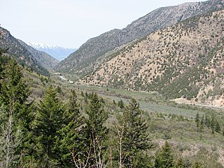
Cache National Forest is a 533,840-acre area of National Forest System land in Idaho and Utah which was established on July 1, 1908 by the U.S. Forest Service. The majority of its area is in Utah, and was initially created when the Bear River National Forest was disbanded. On July 1, 1915, all of Pocatello National Forest was added. In 1973 the Idaho portion was transferred to the administration of Caribou National Forest, while the Utah portion was combined administratively with Wasatch National Forest, creating the Wasatch-Cache National Forest. In descending order of forestland area, the Cache National Forest portion is located in Cache, Bear Lake, Franklin, Weber, Rich, Box Elder, Caribou, and Morgan counties. The forest has a current area of 701,453 acres (2,838.68 km2), which comprises 43.56% of the combined Wasatch-Cache's total acreage. The forest is administered from Salt Lake City, Utah as part of the Wasatch-Cache National Forest, but there are local ranger district offices in Logan and Ogden. From circa 1911 until August 1923, the area was roamed by Old Ephraim.

Wasatch National Forest was established as the Wasatch Forest Reserve by the U.S. Forest Service in Utah on August 16, 1906 with 86,440 acres (349.8 km2) to the east of Salt Lake City and Provo. It became a National Forest on March 4, 1907. On July 1, 1908 Grantsville National Forest and Salt Lake National Forest were added. In 1973 Wasatch was combined administratively with Cache National Forest, creating Wasatch-Cache National Forest. In descending order of acreage, the Wasatch National Forest portion is located in Summit, Tooele, Salt Lake, Davis, Uinta (Wyoming), Duchesne, Wasatch, Morgan, Utah, Weber, and Juab counties in Utah except Uinta, which is in southwestern Wyoming. Its total area was 908,731 acres (3,677.50 km2), comprising 56.44% of the combined Wasatch-Cache's 1,610,184 acres (6,516.18 km2) as of 2008. There are local ranger district offices in Kamas and Salt Lake City in Utah, and in Evanston and Mountain View in Wyoming. Administrative headquarters reside with the combined Uinta-Wasatch-Cache National Forest in South Jordan, Utah.

Yellowstone National Forest was first established by the General Land Office on March 30, 1891 as the Yellowstone Park Timber Land Reserve of 1,239,040 acres (5,014.2 km2). On May 22, 1902 it became the Yellowstone Forest Reserve with lands of 6,580,920 acres (26,632.0 km2).
Ashland National Forest was established as the Ashland Forest Reserve by the General Land Office in Oregon on September 28, 1893 with 18,560 acres (75.1 km2). In 1905 federal forests were transferred to the U.S. Forest Service. Ashland became a National Forest on March 4, 1907, and on July 1, 1908 the entire forest was combined with parts of Cascade, Klamath and Siskiyou National Forests to establish Crater National Forest. The lands are presently included in Rogue River National Forest.
Bull Run National Forest was established as the Bull Run Forest Reserve by the General Land Office in Oregon on June 17, 1892, with 142,080 acres (575.0 km2). After the transfer of federal forests to the U.S. Forest Service in 1905, it became a National Forest on March 4, 1907. On July 1, 1908, the entire forest was combined with part of Cascade National Forest to establish Oregon National Forest and the name was discontinued. The lands are now part of Mount Hood National Forest.
Tumacacori National Forest was established as the Tumacacori Forest Reserve by the U.S. Forest Service in Arizona on November 7, 1906 with 203,550 acres (823.7 km2). It became a National Forest on March 4, 1907. On July 1, 1908 the entire forest was combined with Baboquivari National Forest and Huachuca National Forest to establish Garces National Forest, and the name was discontinued. The lands are presently included in Coronado National Forest.
Battlement Mesa Forest Reserve was established by the General Land Office in Colorado on December 24, 1892 with 858,240 acres (3,473.2 km2). In 1905 all federal forests were transferred to the U.S. Forest Service. On July 1, 1908 part of the forest was combined with Holy Cross National Forest, part was renamed Battlement National Forest, and the original name was discontinued. The lands are presently included in White River National Forest and Grand Mesa National Forest.
Bear Lodge National Forest is a discontinued entity which has been absorbed into the Black Hills National Forest. It is located in the U.S. in the state of Wyoming, in the north central part of the American mainland. It was established in the Bear Lodge Mountains by the U.S. Forest Service in Wyoming on July 1, 1907 with 136,784 acres (553.55 km2). The forest was named for Devils Tower or the "Bear Lodge". On July 1, 1908 the forest was combined with part of Black Hills National Forest to establish Sundance National Forest and the name was discontinued. The lands are presently included in Black Hills National Forest.
Pocatello National Forest was established as the Pocatello Forest Reserve by the General Land Office in Idaho and Utah on September 5, 1903 with 49,920 acres (202.0 km2). After the transfer of federal forests to the U.S. Forest Service in 1905, it became a National Forest on March 4, 1907. On July 1, 1908 Port Neuf National Forest and part of Bear River National Forest were added. On July 1, 1915 the entire forest was transferred to Cache National Forest and the name was discontinued. The lands are presently included in Caribou National Forest and Uinta-Wasatch-Cache National Forest.
Grantsville National Forest was established as the Grantsville Forest Reserve by the General Land Office in Utah on May 6, 1904 with 68,690 acres (278.0 km2). After the transfer of federal forests to the U.S. Forest Service in 1905, it became a National Forest on March 4, 1907. On July 1, 1908 Grantsville was combined with Wasatch National Forest and the name was discontinued. The lands are presently included in Uinta-Wasatch-Cache National Forest.
Salt Lake National Forest was established as the Salt Lake Forest Reserve by the General Land Office in Utah on May 26, 1904 with 95,440 acres (386.2 km2). In 1905 all federal forests were transferred to the U.S. Forest Service. On July 1, 1908 Salt Lake was combined with Wasatch National Forest and the name was discontinued. The lands are presently included in Uinta-Wasatch-Cache National Forest.
Dismal River National Forest was established as the Dismal River Forest Reserve by the General Land Office in Nebraska on April 16, 1902 with 85,123 acres (344.48 km2). After the transfer of federal forests to the U.S. Forest Service in 1905, it became a National Forest on March 4, 1907. On July 1, 1908 the lands were transferred to Nebraska National Forest.
The Chenismus Forest Reserve was established in Oregon by the U.S. Forest Service on May 12, 1905 with 220,320 acres (891.6 km2). On March 1, 1907 it was combined with the first Wallowa National Forest to create Imnaha National Forest and the name was discontinued. Its lands presently exist as a portion of Wallowa–Whitman National Forest.
La Sal National Forest was established as the La Sal Forest Reserve by the U.S. Forest Service in Utah and Colorado on January 25, 1906 with 158,462 acres (641.27 km2), mostly in Utah. It became a National Forest on March 4, 1907. On July 1, 1908 it was combined with Monticello National Forest and renamed La Salle National Forest. On March 16, 1909 it was changed back to La Sal, by now with 474,130 acres (1,918.7 km2). On November 28, 1949 the forest was transferred to Manti National Forest. On August 28, 1950 the name was changed to Manti-La Sal National Forest.
Manti National Forest was established as the Manti Forest Reserve by the General Land Office in Colorado and Utah on May 29, 1903 with 584,640 acres (2,366.0 km2). After the transfer of federal forests to the U.S. Forest Service in 1905, it became a National Forest on March 4, 1907. On July 1, 1915 Nebo National Forest was added. On November 11, 1941, La Sal National Forest was added. On August 28, 1958 the name was changed to Manti-La Sal National Forest. Manti's lands are on the west side of the Colorado River in central Utah, between Manti and Price. In descending order of area, its lands are located in parts of Sanpete (50.3%), Emery (28.96%), Utah (12.59%), Carbon (4.11%), and Sevier (4.05%) counties. As of 30 September 2008 its area was 735,358 acres, representing 57.87% of the combined Manti-La Sal National Forest's total area. There are local ranger district offices in Ephraim, Ferron, and Price, whereas the administrative headquarters of the combined Manti-La Sal National Forest are also in Price.
Vernon National Forest was established as the Vernon Forest Reserve by the U.S. Forest Service in Utah on April 24, 1906 with 68,800 acres (278 km2) in the northwestern part of the state near the town of Vernon. It became a National Forest on March 4, 1907. On July 1, 1908 Vernon and Payson National Forests and part of Fillmore were combined to create Nebo National Forest. The lands presently managed under the Uinta-Wasatch-Cache National Forest.
The Pacific Forest Reserve was established by the General Land Office in Washington on February 20, 1893 with 967,680 acres (3,916.1 km2). On February 22, 1898 the forest was combined with other lands to create the Mount Rainier Forest Reserve, and the name was discontinued.
Monticello National Forest was established as the Monticello Forest Reserve by the U.S. Forest Service in Utah on February 6, 1907 with 214,270 acres (867.1 km2). It became a National Forest on March 4, 1907. On July 1, 1908 it was combined with La Sal National Forest, which was renamed La Salle National Forest for a short time. The lands presently exist in Manti-La Sal National Forest.
The Grand Cañon Forest Reserve was established by the General Land Office in Arizona on February 20, 1893 with 1,851,250 acres (7,491.7 km2). It was renamed Grand Canyon on August 8, 1906 and transferred to the U.S. Forest Service becoming a National Forest on March 4, 1907. On July 1, 1908 the entire forest was divided between Coconino National Forest and the newly established Kaibab National Forest, while other areas were returned to public lands, and the name was discontinued.

