
Cache County is a county located in the Wasatch Front region of Utah. As of the 2020 United States Census, the population was 133,154, with an estimated 140,173 in 2022. Its county seat and largest city is Logan. Cache County is one of two counties included in the Logan metropolitan area, alongside Franklin County, Idaho.
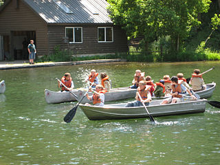
Scouting in Utah has a long history, from the 1910s to the present day, serving thousands of youth in programs that suit the environment in which they live.

The Okanogan–Wenatchee National Forest is a U.S. National Forest located in Okanogan County in north-central Washington, United States.
The Bear River is the largest tributary of the Great Salt Lake, draining a mountainous area and farming valleys northeast of the lake and southeast of the Snake River Plain. It flows through northeastern Utah, southwestern Wyoming, southeastern Idaho, and back into northern Utah, in the United States. Approximately 350 miles (560 km) long it is the longest river in North America that does not ultimately reach the sea.

The Nez Perce National Forest is a 4,000,000-acre (16,000 km2) United States National Forest located in west-central Idaho. The forest is bounded on the east by the state of Montana, on the north by the Clearwater National Forest, on the west by a portion of the Wallowa–Whitman National Forest and on the south by the Payette National Forest.

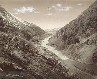
Logan Canyon is a canyon in the western United States in northeastern Utah, which cuts its way through the Bear River Mountains, a branch of the Wasatch Range. It is popular for both summer and winter activities, especially rock-climbing, hiking, camping, fishing, snowmobiling, and skiing, at the Beaver Mountain ski resort. The canyon rises to an elevation of approximately 7,800 feet (2,400 m) above sea level, after a vertical climb of about 2,900 feet (880 m). Just beyond the summit is a steep road leading into Bear Lake Valley and scenic overlooks that provide views of deep blue Bear Lake. The western terminus is at Logan in Cache County and the eastern terminus is at Garden City in Rich County.

The Beaverhead–Deerlodge National Forest is the largest of the National Forests in Montana, United States. Covering 3.36 million acres (13,600 km2), the forest is broken into nine separate sections and stretches across eight counties in the southwestern area of the state. President Theodore Roosevelt named the two forests in 1908 and they were merged in 1996. Forest headquarters are located in Dillon, Montana. In Roosevelt's original legislation, the Deerlodge National Forest was called the Big Hole Forest Reserve. He created this reserve because the Anaconda Copper Mining Company, based in Butte, Montana, had begun to clearcut the upper Big Hole River watershed. The subsequent erosion, exacerbated by smoke pollution from the Anaconda smelter, was devastating the region. Ranchers and conservationists alike complained to Roosevelt, who made several trips to the area. (Munday 2001)

Bitterroot National Forest comprises 1.587 million acres (6,423 km2) in west-central Montana and eastern Idaho of the United States. It is located primarily in Ravalli County, Montana, but also has acreage in Idaho County, Idaho (29.24%), and Missoula County, Montana (0.49%).

Caribou–Targhee National Forest is located in the states of Idaho and Wyoming, with a small section in Utah in the United States. The forest is broken into several separate sections and extends over 2.63 million acres (10,600 km2). To the east the forest borders Yellowstone National Park, Grand Teton National Park and Bridger–Teton National Forest. Most of the forest is a part of the 20-million-acre (81,000 km2) Greater Yellowstone Ecosystem.

The Kaniksu National Forest is a U.S. National Forest located in northeastern Washington, the Idaho Panhandle, and northwestern Montana. It is one of three forests that are aggregated into the Idaho Panhandle National Forests, along with the Coeur d'Alene National Forest and St. Joe National Forest. Kaniksu National Forest has a total area of 1,627,833 acres (6,587.6 km2). About 55.7% is in Idaho, 27.9% in Montana, and 16.4% in Washington.

Ashley National Forest is a National Forest located in northeastern Utah and southwestern Wyoming. Within the Forest's bounds are 1,382,346 acres (5,594 km2) of vast forests, lakes, and mountains, with elevations ranging from 6,000 to 13,500 feet. The forest covers portions of Daggett, Duchesne, Summit, Uintah, and Utah counties in Utah and Sweetwater County in Wyoming. Some of the most popular landmarks located in the forest include the Flaming Gorge National Recreation Area and the Uinta Mountains, which contains the highest mountain peak in Utah. The forest also includes 276,175 acres (1,117.64 km2), or about 60.5%, of the High Uintas Wilderness. The headquarters for the Ashley National Forest are located in Vernal, Utah with ranger district offices in Vernal; Duchesne, Utah; Roosevelt, Utah; Manila, Utah; and Green River, Wyoming.

The Manti–La Sal National Forest covers more than 1.2 million acres (4,900 km2) and is located in the central and southeastern parts of the U.S. state of Utah and the extreme western part of Colorado. The forest is headquartered in Price, with ranger district offices in Price, Ferron, Ephraim, Moab and Monticello. The maximum elevation is Mount Peale in the La Sal Mountains, reaching 12,721 feet (3,877 m) above sea level. The La Sal Mountains are the second highest mountain range in Utah after the Uintas. Parts of the forest are included in the Bears Ears National Monument.

Uinta National Forest is a national forest located in north central Utah, US. It was originally part of the Uinta Forest Reserve, created by President Grover Cleveland on 2 February 1897. The name is derived from the Ute word Yoov-we-teuh which means pine forest. Because of changes to the boundaries over the years, the Uinta Mountains are now located in the Wasatch-Cache National Forest. In August 2007 it was announced that the Uinta National Forest would merge with the Wasatch–Cache National Forest based in Salt Lake City, Utah, 50 miles (80 km) north of Provo, Utah.

Wasatch–Cache National Forest is a United States National Forest located primarily in northern Utah (81.23%), with smaller parts extending into southeastern Idaho (16.42%) and southwestern Wyoming (2.35%). The name is derived from the Ute word Wasatch for a low place in high mountains, and the French word Cache meaning to hide. The term cache originally referred to fur trappers, the first Europeans to visit the land. The Wasatch–Cache National Forest boundaries include 1,607,177 acres (6,504.01 km2) of land.
Wallowa National Forest was first established as the Wallowa Forest Reserve in Oregon on May 6, 1905 with 747,200 acres (3,024 km2). On March 1, 1907 it was combined with the Chenismus Forest Reserve to create Imnaha National Forest, which was then renamed Wallowa on July 1, 1908. In 1954 it was administratively combined with Whitman National Forest to make Wallowa–Whitman National Forest. The Wallowa National Forest is located overwhelmingly in Wallowa County, Oregon, but there are much smaller portions in Union County, Oregon and Nez Perce and Idaho counties in Idaho. There are local ranger district offices in Enterprise and La Grande, both in Oregon. Forest headquarters are in Baker City, as part of Wallowa-Whitman National Forest. As of 30 September 2008, the Wallowa portion had an area of 997,063 acres (4,034.97 km2), comprising about 44% of the Wallowa-Whitman's acreage.

Wasatch National Forest was established as the Wasatch Forest Reserve by the U.S. Forest Service in Utah on August 16, 1906 with 86,440 acres (349.8 km2) to the east of Salt Lake City and Provo. It became a National Forest on March 4, 1907. On July 1, 1908 Grantsville National Forest and Salt Lake National Forest were added. In 1973 Wasatch was combined administratively with Cache National Forest, creating Wasatch-Cache National Forest. In descending order of acreage, the Wasatch National Forest portion is located in Summit, Tooele, Salt Lake, Davis, Uinta (Wyoming), Duchesne, Wasatch, Morgan, Utah, Weber, and Juab counties in Utah except Uinta, which is in southwestern Wyoming. Its total area was 908,731 acres (3,677.50 km2), comprising 56.44% of the combined Wasatch-Cache's 1,610,184 acres (6,516.18 km2) as of 2008. There are local ranger district offices in Kamas and Salt Lake City in Utah, and in Evanston and Mountain View in Wyoming. Administrative headquarters reside with the combined Uinta-Wasatch-Cache National Forest in South Jordan, Utah.

Apache National Forest was established by the U.S. Forest Service in Arizona and New Mexico on July 1, 1908, with 1,302,711 acres (5,271.88 km2) from portions of Black Mesa National Forest. In 1974 the entire forest was administratively combined with Sitgreaves National Forest to create Apache-Sitgreaves National Forests. The New Mexico section is now administered by the Gila National Forest. The area of the former Apache National Forest covers most of Greenlee County, Arizona, southern Apache County, Arizona, and part of western Catron County, New Mexico. The former Apache is much the larger than the former Sitgreaves. As of 30 September 2008, its area was 1,813,601 acres (733,938 ha), representing 68.9% of the combined Apache–Sitgreaves total area. There are local ranger district offices in Alpine, Clifton, and Springerville.
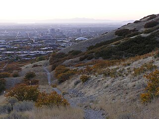
The Bonneville Shoreline Trail is a mixed use (biking/hiking) recreation trail in Utah that roughly follows the shoreline of the ancient Lake Bonneville, a prehistoric pluvial lake which existed in northern Utah before naturally draining about 14,000 years ago. Some sections of the trail are complete while other parts are still being developed. The Bonneville Shoreline Trail hopes to one day stretch from the Idaho border and run southward all the way to Nephi, Utah.
Mount Naomi Wilderness is a 44,523-acre (180.18 km2) wilderness area located within the Uinta-Wasatch-Cache National Forest in the U.S. state of Utah. It lies between the Logan River and the Utah-Idaho state line northeast of Logan, Utah.
Pocatello National Forest was established as the Pocatello Forest Reserve by the United States General Land Office in Idaho and Utah on September 5, 1903, with 49,920 acres (202.0 km2). After the transfer of federal forests to the U.S. Forest Service in 1905, it became a National Forest on March 4, 1907. On July 1, 1908, Port Neuf National Forest and part of Bear River National Forest were added. On July 1, 1915, the entire forest was transferred to Cache National Forest and the name was discontinued. The lands are presently included in Caribou National Forest and Uinta-Wasatch-Cache National Forest.
