Bearcreek owes its existence to area coal mining that began in the 1890s to supply coal for the Northern Pacific Railway and the Anaconda Company. The Bearcreek Post Office was established on November 22, 1905, with Sarah Criger as the town's first postmaster.[4] The town was platted and incorporated after the arrival of the Montana, Wyoming & Southern Railroad in 1906.
The town of Bearcreek was named for Bear Creek, which runs through the middle of town. Bearcreek came into existence due to coal mines and grew rapidly following the building of a short line railroad connecting the Bearcreek mines to the Northern Pacific Railroad in 1906. Between 1906 and 1953, the mines at Bearcreek produced large volumes of coal, which was a higher grade than other regional sources, from the extensive underground coal mining deposits. The mines were located along the creek and also in the surrounding coulees. The development of the coal mines after 1906 drew miners to the area. They came from other parts of America, and from Serbia, Montenegro, Germany, Scotland and Italy. The recent immigrants built separate ethnic-based communities in the steep coulees that run down into Bearcreek, with names like Washoe, New Caledonia, Chickentown, Scotch Coulee, International, and Stringtown. At one time in the 1920s and 1930s the population of Bearcreek combined with the other surrounding small communities was close to 3,000 persons. Bearcreek and the surrounding communities had seven mercantiles, a bank, two hotels, two billiard halls, a brickyard, numerous saloons, and Bearcreek sported concrete sidewalks and their own water system. Allegedly, the town had no churches. The economy of Bear Creek was based on coal. The Smith Mine Disaster in 1943, followed by the decline in demand for coal in the late 1940s and 1950s caused the closure of the connecting railroad in 1953 and subsequently most of the coal mines, and the population declined steadily to less than 100 persons. Many buildings in Bearcreek and the surrounding communities were moved to other towns or demolished, and only a few structures remain.
The town is home to the Bearcreek Saloon which hosts fundraising pig races throughout the year. In addition, Bearcreek plays host every autumn to Montana Falconer Symposium, the state's largest gathering of falcon trainers and birds of prey enthusiasts.[citation needed]
When the legality of betting on pig races was challenged, a law was passed—Montana Code Annotated 23-5-502(b) -- stating that "Only a licensee of premises that are located in an incorporated city or town with a population of less than 100 or located outside the boundaries of an incorporated city or town and that are appropriately licensed to sell alcoholic beverages for consumption on the premises under 23-5-119 may conduct a race between animals and conduct one or more sports pools on the race. The race may be conducted only if it is between pigs, gerbils, or hamsters and is conducted on the premises but outside of interior areas of the establishment where food and beverages are usually stored, prepared, or served."[5]
Featured in the Star Trek Television series Strange New Worlds Episode 1 of Season 1.
The Montana Wyoming and Southern Railroad
The Montana, Wyoming and Southern (or MW&S) was an independent privately owned short rail spur built in 1906 from the main Northern Pacific Railroad (NP) line at Bridger, Montana through Belfry and on to the mines in and around Bearcreek. The tremendous amounts of coal extracted from the Bearcreek mines all traveled over this 21 mile long spur. The MW&S was built by speculators hoping it could be immediately sold to the NP who used the high grade coal from the Bearcreek mines in their engines. However, since the MW&S's single outlet to the wider world was all through the NP terminus at Bridger, the Northern Pacific did not buy this short line but sought to control it through business interactions. The MW&S was forced to operate on its own under constant financial pressure from the NP, and even though it shipped large volumes of high grade coal from Bearcreek it was often in financial and operational difficulties. The Bearcreek mine owners were in turn completely dependent on the MW&S to move their shipments. The MW&S existed as a vacillating and weak but critical link to the continued prosperity of the community of Bearcreek.[6]
Attraction of American and foreign born workers
After the MW&S railroad was built, Bearcreek expanded rapidly as coal production increased. American and foreign-born workers moved there, drawn by the expanding coal mining activity and the promise of steady work. By 1917, the mines around Bearcreek were employing 1,200 men. As the miners came they settled in small communities built in the small steep coulees running down into Bear Creek. At its peak, Bearcreek and the surrounding communities of Washoe, New Caledonia, Chickentown, Scotch Coulee, International, and Stringtown, had a population of about 3,000 people, most of whom worked in the coal mines.[citation needed]
From 1906 onward, Bearcreek attracted a large contingent of Serbian/Slavic immigrants from Serbia and Montenegro. The many Serb families brought their culture and their customs to Bearcreek. With its diverse ethnic composition, Bearcreek traditionally celebrated Christmas twice, on December 25 and January 6, the Serbian Orthodox Church holiday.[7]
Smith Mine Disaster
On February 27, 1943, the Smith Mine #3 exploded in the worst coal mining accident in the history of Montana. Of the 77 men who had gone underground at the start of the shift, only 3 survived. The bodies were all recovered. Thirty had died instantly. Forty four of the miners survived the initial blast, but were trapped underground in isolated parts of the mine, dying from initial injuries or from suffocation from methane and carbon monoxide poisoning. Some left farewell notes to their families. The Smith Mine never reopened and this disaster dealt a severe blow to the community.
Events after the Smith Mine Disaster
In the late 1940s and early 1950s, there was a marked trend away from coal consumption in the American economy, due to utilization of natural gas or fuel oil for heating and the increasing use of diesel to power locomotives. Bearcreek's coal production went into a steady decline.
After the abrupt closure of the Smith Mine, and as the demand for coal declined so did the financial health of the Montana, Wyoming and Southern, which had always been precarious. The railroad ceased to operate in 1953. When the railroad ceased to function so did most of mining activity in and around Bearcreek, since the railroad was the only efficient way for mines to ship their coal to market. Some mines struggled on, but the last mine closed in the 1970s. After the closure of the railroad followed by most of the mines the town's population rapidly dwindled, eventually declining to under 100 people. The rails and ties were removed from the railroad bed and over time the many empty miners houses that once filled the coulees along Bear Creek were sold and moved, or they simply sat vacant and deteriorated until they were torn down.
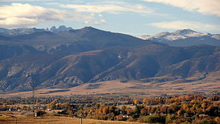
Today, the many surrounding communities that made up Bearceek are almost completely gone, with only a few houses marking Washoe, currently the largest of them.[8] In the last decades there is some growth of the tiny remaining community of Bearcreek thanks to its proximity to Red Lodge which has developed an economy to serve tourists who come to ski, or to use summer cabins, or to pass through to Yellowstone Park.[9]
As of the census[13] of 2010, there were 79 people, 44 households, and 20 families residing in the town. The population density was 658.3 inhabitants per square mile (254.2/km2). There were 51 housing units at an average density of 425.0 per square mile (164.1/km2). The racial makeup of the town was 98.7% White and 1.3% from two or more races.
There were 44 households, of which 15.9% had children under the age of 18 living with them, 40.9% were married couples living together, 2.3% had a female householder with no husband present, 2.3% had a male householder with no wife present, and 54.5% were non-families. 43.2% of all households were made up of individuals, and 13.6% had someone living alone who was 65 years of age or older. The average household size was 1.80 and the average family size was 2.50.
The median age in the town was 53.5 years. 13.9% of residents were under the age of 18; 1.3% were between the ages of 18 and 24; 17.8% were from 25 to 44; 39.2% were from 45 to 64; and 27.8% were 65 years of age or older. The gender makeup of the town was 49.4% male and 50.6% female.
2000 census
As of the census[14] of 2000, there were 83 people, 38 households, and 22 families residing in the town. The population density was 690.3 inhabitants per square mile (266.5/km2). There were 40 housing units at an average density of 332.7 per square mile (128.5/km2). The racial makeup of the town was 96.39% White, 1.20% African American, and 2.41% from two or more races.
There were 38 households, out of which 31.6% had children under the age of 18 living with them, 34.2% were married couples living together, 18.4% had a female householder with no husband present, and 39.5% were non-families. 34.2% of all households were made up of individuals, and 7.9% had someone living alone who was 65 years of age or older. The average household size was 2.18 and the average family size was 2.35.
In the town, the population was spread out, with 21.7% under the age of 18, 10.8% from 18 to 24, 33.7% from 25 to 44, 28.9% from 45 to 64, and 4.8% who were 65 years of age or older. The median age was 35 years. For every 100 females, there were 97.6 males. For every 100 females age 18 and over, there were 85.7 males.
The median income for a household in the town was $32,917, and the median income for a family was $32,500. Males had a median income of $20,250 versus $25,000 for females. The per capita income for the town was $13,572. There were 3.8% of families and 12.6% of the population living below the poverty line, including 20.0% of under eighteens and none of those over 64.
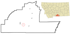
Carbon County is a county located in the U.S. state of Montana. As of the 2020 census, the population was 10,473. Its county seat is Red Lodge.
Macoupin County is located in the U.S. state of Illinois. According to the 2020 census, it had a population of 44,967. The county seat is Carlinville.
Breese is a city in Clinton County, Illinois, United States. Breese is the most populous city completely within Clinton County. As of the 2020 census, the population was 4,641, the majority of whom are of German ancestry. Breese is part of the Metro-East region of the Greater St. Louis metropolitan area.
Lucas is a city in Lucas County, Iowa, United States. The population was 172 at the time of the 2020 census.
Oskaloosa is a city in, and the county seat of, Mahaska County, Iowa, United States. In the late nineteenth and early twentieth century, Oskaloosa was a national center of bituminous coal mining. The population was 11,558 in the 2020 U.S. census.
Marysville is a city in Marion County, Iowa, United States. The population was 44 at the time of the 2020 census.
Belfry is a census-designated place (CDP) in Carbon County, Montana, United States. It is part of the Billings, Montana Metropolitan Statistical Area. The population was 218 at the 2010 census. It is located approximately 11 miles (18 km) from the Wyoming border, roughly halfway between Billings, Montana and Cody, Wyoming.
Red Lodge is a city and county seat of Carbon County, Montana, United States. As of the 2020 census, the population of the city was 2,257.
Basin is an unincorporated community and census-designated place (CDP) in Jefferson County, Montana, United States. It lies approximately 10 miles (16 km) southeast of the Continental Divide in a high narrow canyon along Interstate 15 about halfway between Butte and Helena. Basin Creek flows roughly north to south through Basin and enters the Boulder River on the settlement's south side. The population was 212 at the 2010 census, down from 255 at the 2000 census.
McCurtain is a town in Haskell County, Oklahoma, United States. The population was 357 at the 2020 census, a 30.8% decrease over the figure of 516 recorded in 2010. A coal mine disaster in 1912 killed 73 miners and ended McCurtain's prosperity. The mine explosion remains one of the worst disasters in Oklahoma history.
Exeter is a borough in the Greater Pittston-Wilkes-Barre area of Luzerne County, Pennsylvania, United States, about 10 miles (16 km) west of Scranton and a few miles north of Wilkes-Barre. It is located on the western bank of the Susquehanna River and has a total area of 5.0 square miles (12.9 km2). As of 2020, Exeter had a population of 5,513.
Newport Township is a township in Luzerne County, Pennsylvania, United States. As of 2020, the population was 4,444. Newport is located on the outskirts of Nanticoke City.
McIntyre Township is a township in Lycoming County, Pennsylvania, United States. The population was 460 at the 2020 census. It is part of the Williamsport Metropolitan Statistical Area.
Crabtree is a census-designated place (CDP) and former coal town in Salem Township, Westmoreland County, Pennsylvania, United States. The population was 277 at the 2010 census. It has its own post office, with postal code 15624.
Donegal Township is a township in Westmoreland County, Pennsylvania, United States. The population was 2,192 at the 2020 census, a decrease of 9% compared to 2010.
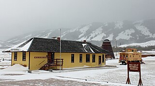
Centennial is a small mountain-town in Albany County, Wyoming, United States. It serves a fairly large surrounding landscape, along with a few ranches, located along a gently sloping hillside traversed by a highway. Because it has been, since 1980 or later, included in a census-designated place (CDP), bearing the town's name, specific demographics characterizing the town itself are not available.
Wright is a town in Campbell County, Wyoming, United States. The population was 1,807 at the 2010 census.
Glenrock is a town in Converse County, Wyoming, United States. The population was 2,576 at the 2010 census.
Sheridan is a city in the U.S. state of Wyoming and the county seat of Sheridan County. The city is located halfway between Yellowstone Park and Mount Rushmore by U.S. Route 14 and 16. It is the principal town of the Sheridan, Wyoming, Micropolitan Statistical Area which encompasses all of Sheridan County. The 2020 census put the city's population at 18,737, making it the 6th most populous city in Wyoming.
Washoe is a settlement in Carbon County, Montana, United States, situated at the foot of the Beartooth Mountains. It is situated on Montana Secondary Highway 308.
↑ Montana Place Names Companion Website. Aarstad, Rich, Ellie Arguimbau, Ellen Baumler, Charlene Porsild, and Brian Shovers. Montana Place Names from Alzada to Zortman. Montana Historical Society Press.
↑ Baker, Don (1997). Ghost Towns of the Montana Prairie. Golden, Colorado: Fred Pruett Books. pp.20–21. ISBN0-87108-050-8.
This page is based on this Wikipedia article Text is available under the CC BY-SA 4.0 license; additional terms may apply. Images, videos and audio are available under their respective licenses.