Related Research Articles

An orogeny is an event that leads to both structural deformation and compositional differentiation of the Earth's lithosphere at convergent plate margins. An orogen or orogenic belt develops when a continental plate crumples and is uplifted to form one or more mountain ranges; this involves a series of geological processes collectively called orogenesis.

The Ellsworth Mountains are the highest mountain ranges in Antarctica, forming a 350 km (217 mi) long and 48 km (30 mi) wide chain of mountains in a north to south configuration on the western margin of the Ronne Ice Shelf in Marie Byrd Land. They are bisected by Minnesota Glacier to form the Sentinel Range to the north and the Heritage Range to the south. The former is by far the higher and more spectacular with Mount Vinson constituting the highest point on the continent. The mountains are located within the Chilean Antarctic territorial claim but outside of the Argentinian and British ones.

The Variscan or Hercynianorogeny was a geologic mountain-building event caused by Late Paleozoic continental collision between Euramerica (Laurussia) and Gondwana to form the supercontinent of Pangaea.

The Grenville orogeny was a long-lived Mesoproterozoic mountain-building event associated with the assembly of the supercontinent Rodinia. Its record is a prominent orogenic belt which spans a significant portion of the North American continent, from Labrador to Mexico, as well as to Scotland.
The Napier Mountains are a group of close set peaks, the highest being Mount Elkins, at about 2,300 meters above sea level. This mountain range is located in Enderby Land, in the claimed Australian Antarctic Territory, East Antarctica.

The geology of Australia includes virtually all known rock types and from all geological time periods spanning over 3.8 billion years of the Earth's history. Australia is a continent situated on the Indo-Australian Plate.

The geology of Antarctica covers the geological development of the continent through the Archean, Proterozoic and Phanerozoic eons.

Mount Elkins, also known as Jökelen is a dark, steep-sided mountain with three major peaks, the highest 2,300 meters (7,500 ft) above sea level, in the Napier Mountains of Enderby Land. Enderby Land part of East Antarctica, and is claimed by Australia as part of the Australian Antarctic Territory. The mountain was named after Terence James Elkins, an ionospheric physicist with the Australian National Antarctic Research Expeditions at Mawson Station in 1960.

The East Antarctic Shield or Craton is a cratonic rock body that covers 10.2 million square kilometers or roughly 73% of the continent of Antarctica. The shield is almost entirely buried by the East Antarctic Ice Sheet that has an average thickness of 2200 meters but reaches up to 4700 meters in some locations. East Antarctica is separated from West Antarctica by the 100–300 kilometer wide Transantarctic Mountains, which span nearly 3,500 kilometers from the Weddell Sea to the Ross Sea. The East Antarctic Shield is then divided into an extensive central craton that occupies most of the continental interior and various other marginal cratons that are exposed along the coast.

Enderby Land is a region of Northeastern Antarctica which extends into the Southern Indian Ocean. The area is claimed by Australia as part of the Australian Antarctic Territory. The unique and diverse geological features of this region have been associated with the evolution and development of the supercontinent Gondwana. Multiple distinct geological formations are located in this region. The most prominent and important are the
- Napier Complex (Archaean)
- Rayner Complex (late-Proterozoic)
- Lützow-Holm Complex (LHC) (early-Paleozoic)
- Yamato–Belgica Complex (early-Paleozoic)

Patagonia comprises the southernmost region of South America, portions of which lie either side of the Chile–Argentina border. It has traditionally been described as the region south of the Rio Colorado, although the physiographic border has more recently been moved southward to the Huincul fault. The region's geologic border to the north is composed of the Rio de la Plata craton and several accreted terranes comprising the La Pampa province. The underlying basement rocks of the Patagonian region can be subdivided into two large massifs: the North Patagonian Massif and the Deseado Massif. These massifs are surrounded by sedimentary basins formed in the Mesozoic that underwent subsequent deformation during the Andean orogeny. Patagonia is known for their vast earthquakes and the damage.
The Insel orogeny was a mountain building event in the late Archean, 2.65 billion years ago, in what is now Antarctica. First identified by geologists in Queen Maud Land and the southern Prince Charles Mountains, the orogeny produced rocks that reached amphibolite-grade on the sequence of metamorphic facies, produced large areas of new continental crust and altered the large areas of older rock. In the 1970s and 1980s, Antarctic researchers Grikurov and Elliot debated whether the Insel Orogeny marked the end of craton building in East Antarctica, or whether the process continued into the Proterozoic.
The Early Ruker orogeny was a mountain building event from 2.0 to 1.7 billion years ago in the Proterozoic and a key event in the assembly of Antarctica. Much of central Antarctica was added to the nucleus of the continent during this time period. The event resulted in widespread formation of intra-cratonic miogeoclinal basins. Outcrops of rocks in the southern Prince Charles Mountains contain cross-bedded shale, sandstone, conglomerate, mudstone and ironstone. Many of these rocks were deformed and metamorphosed close to the end of the orogeny around 1.7 billion years ago.
The Late Ruker orogeny also known as the Nimrod orogeny was a mountain building event around 1 billion years ago in the Proterozoic. Large portions of West Antarctica were added to the continent during this event. The orogeny was marked by subsidence, sedimentation and underwater volcanic eruptions along the proto-Pacific Ocean margin of proto-Antarctica. This melted some older igneous plutonic rocks and metamorphic rocks and caused some new metamorphism.
The Borchgrevink orogeny also termed the Borchgrevink event is a proposed mountain building event in Antarctica in the Devonian and Silurian. The event is recorded by metamorphic rocks in Victoria Land as well as igneous and metamorphic rocks found throughout Marie Byrd Land, Thurston Island and the Antarctic Peninsula.
The Ross orogeny was a mountain building event in Antarctica in the early Paleozoic. The ancestral Trans-Antarctic Mountains were uplifted earlier by the Beardmore orogeny but had eroded as a broad epicratonic sea flooded much of Antarctica in the Cambrian. Shallow water sedimentary rocks, platform carbonates and deepwater turbidites from this period are found in the mountain range. The Ross orogeny was one of the most extensive orogenic events in Antarctica, causing widespread plutonism and metamorphism. Bimodal magmatism and extension mark the beginnings of the orogeny, while during the later phase sedimentary rocks at the continental margin were deformed, metamorphosed and intruded with granite batholiths. Interpretations of rock forms in Antarctica during the 1980s suggested a westward-dipping subduction zone may have formed along the paleo-Pacific Ocean shoreline of East Antarctica. This is inferred from a large number of I-type and S-type granitoids which are similar to large circum-Pacific batholiths.
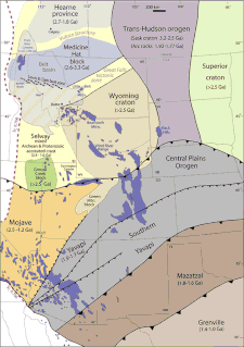
The Mazatzal orogeny was an orogenic event in what is now the Southwestern United States from 1650 to 1600 Mya in the Statherian Period of the Paleoproterozoic. Preserved in the rocks of New Mexico and Arizona, it is interpreted as the collision of the 1700-1600 Mya age Mazatzal island arc terrane with the proto-North American continent. This was the second in a series of orogenies within a long-lived convergent boundary along southern Laurentia that ended with the ca. 1200–1000 Mya Grenville orogeny during the final assembly of the supercontinent Rodinia, which ended an 800-million-year episode of convergent boundary tectonism.
The Yavapai orogeny was an orogenic event in what is now the Southwestern United States from 1710 to 1680 Mya in the Statherian Period of the Paleoproterozoic. Preserved in the rocks of New Mexico and Arizona, it is interpreted as the collision of the 1800-1700 Mya age Yavapai island arc terrane with the proto-North American continent. This was the first in a series of orogenies within a long-lived convergent boundary along southern Laurentia that ended with the ca. 1200–1000 Mya Grenville orogeny during the final assembly of the supercontinent Rodinia, which ended an 800-million-year episode of convergent boundary tectonism.
The Picuris orogeny was an orogenic event in what is now the Southwestern United States from 1.43 to 1.3 billion years ago in the Calymmian Period of the Mesoproterozoic. The event is named for the Picuris Mountains in northern New Mexico and interpreted either as the suturing of the Granite-Rhyolite crustal province to the southern margin of the proto-North American continent Laurentia or as the final suturing of the Mazatzal crustal province onto Laurentia. According to the former hypothesis, this was the second in a series of orogenies within a long-lived convergent boundary along southern Laurentia that ended with the ca. 1200–1000 Mya Grenville orogeny during the final assembly of the supercontinent Rodinia, which ended an 800-million-year episode of convergent boundary tectonism.
References
- ↑ Anderson, John B. (1999). "Antarctic Marine Geology". Cambridge University Press. p. 30-32. ISBN 9780521593175.
- ↑ Laird, Malcolm (1991). Tingey, Robert (ed.). The Late Proterozoic-Middle Palaeozoic rocks of Antarctica, in The Geology of Antarctica. Oxford: Clarendon Press. pp. 82–83, 104, 108. ISBN 0198544677.
| This orogeny article is a stub. You can help Wikipedia by expanding it. |