Related Research Articles

Warwick is a local government district of central Warwickshire in England. It borders the Borough of Rugby and Stratford-on-Avon District in Warwickshire as well as the West Midlands County. The City of Coventry is to the north and northeast, the Stratford-on-Avon District to the southwest and south, the Borough of Rugby to the east, and the Borough of Solihull to the west and northwest.

Quinton is a civil parish in the Stratford-on-Avon district of Warwickshire, England, about six miles south of Stratford-upon-Avon. According to the 2001 Census it had a population of 1,503, increasing to 1,968 at the 2011 Census. The parish contains Upper Quinton and Lower Quinton. It lies on the Heart of England Way.

Aslackby and Laughton is a civil parish in the South Kesteven district of Lincolnshire, England. According to the 2001 census the parish had a population of 243, in 102 households. increasing slightly to 251 in 118 households at the 2011 census. It consists of the village of Aslackby, the hamlet of Laughton, and scattered farms, and part of the hamlet of Graby.
Beausale is a hamlet in the Warwick district of Warwickshire, England, north-west of Warwick. According to the 2001 Census it had a population of 202. It lies within the civil parish of Beausale, Haseley, Honiley and Wroxall.
Billesley is a village and civil parish in the Stratford district of Warwickshire, England, just off the A46 road, between Stratford and Alcester. According to the 2001 Census, the parish had a population of 46. From the 2011 Census the population of the civil parish had been included with Haselor. The population of Billesley is divided into three categories: The Kerby family, The Mumfords, and the staff of the well-known Billesley Manor Hotel. Billesley is mentioned in the Domesday Book, and is so called because 'The Lea' belonged to Billesley. It had a population of about 150 at that time, but most of them were wiped out by the Black Death.

Bitchfield and Bassingthorpe is a civil parish which includes Boothby Pagnell and Burton Coggles in the South Kesteven district of Lincolnshire, England. According to the 2001 census it had a population of 154 across 59 homes. By the 2011 census there were 157 households, made of 366 people.
Blackdown is a hamlet and civil parish in the Warwick district of Warwickshire, England. Blackdown is about two miles north of Leamington Spa, between Leamington/Warwick and Kenilworth. It is named Blakedon in William Dudgale's Antiquities of Warwickshire in 1656 as a district within the parish of Lillington, and as having a mill on the River Avon. Blackdown Mill on Wooton Road is Grade II listed. According to the 2001 Census it had a population of 128. From the 2011 Census population details are included with Old Milverton. Blackdown Manor is a Grade II listed house on Kenilworth Road: built in the 17th century, it was remodelled in the 19th century. Just outside the village is Quarry Park Disc Golf Club which is one of only 17 courses in the United Kingdom, and was the venue for the 2008 UK championships as well as being due to host the 2009 championships. Old Leamingtonians, the town's rugby union and Leamington Royals also play home games on the edge of the village.
Boylestone is a village and civil parish in the Derbyshire Dales district of Derbyshire, England. According to the 2001 census it had a population of 165, increasing to 318 at the 2011 Census. The village is situated about eight miles east of Uttoxeter.
Haseley is a small village in Warwickshire, England. It is four miles north-west of the county town of Warwick and nine miles (14.5 km) south-east of Solihull, in the civil parish of Beausale, Haseley, Honiley and Wroxall, created in 2007. The village is on the A4177 and is easily accessible as it is only five miles (8 km) from the M40 motorway. Haseley proper, along with Haseley Knob, Haseley Green and Waste Green, consists mainly of detached houses spread over a large area, giving the parish a very low housing density. There were, according to the 2001 census, 207 residents living in 92 dwellings. It is an affluent area, with an average house price of around £277,000. Due to this and its proximity to the tourist towns of Warwick and Stratford upon Avon there are several large and highly rated hotels around the village.
Honiley is a small village in the civil parish of Beausale, Haseley, Honiley and Wroxall, in Warwickshire, England. It is 2.5 miles (4 km) from Kenilworth, and 5.5 miles (9 km) from Coventry on the A4177 road. The 2001 Census recorded a parish population of 62. Honiley was merged with adjoining parishes in 2007 and can now be found under Beausale, Haseley, Honiley and Wroxall.
Wroxall is a small village in the civil parish of Beausale, Haseley, Honiley and Wroxall in the county of Warwickshire, England. It is 4.0 miles (6.4 km) from Kenilworth, and 6.5 miles (10.5 km) from Coventry on the A4141 road. According to the 2001 census the village had a population of 94, but beginning with the 2011 Census was included in the civil parish of Beausale, Haseley, Honiley and Wroxall. It has its own cemetery to the north of the village. By far the most important part of the village is the Wroxall Abbey Estate. Built in 1141 by Sir Hugh de Hatton it was a Benedictine Priory for nearly four hundred years, finally closing in 1536 at the Dissolution of the Monasteries.
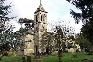
Rowington is a village and civil parish in the English county of Warwickshire. It is five miles north-west of the town of Warwick and five miles south-west of the town of Kenilworth. The parish, which also includes Lowsonford, Pinley and Mousley End, had a population of 925 according to the 2001 UK Census, increasing to 944 at the 2011 Census. The Grand Union Canal runs just south of the village and the M40 motorway is also close by. The Heart of England Way for long-distance walkers passes through the village. The parish church of St. Laurence which dates from medieval times is found on a hill in the centre of the village. In the Tudor era Rowington manor was owned by Catherine Parr, the sixth wife of King Henry VIII of England.

Wroxall Abbey is a substantial Victorian mansion house situated at Wroxall, Warwickshire which was converted for use as a hotel, spa, wedding venue and conference centre. It is a Grade II listed building.
Whitchurch is a parish and a small hamlet lying on the left bank of the River Stour in Warwickshire, England, some four miles south-south-east of the town of Stratford-upon-Avon.

Great Haseley is a village and civil parish in South Oxfordshire, England. The village is about 4.5 miles (7 km) southwest of Thame. The parish includes the hamlets of Latchford, Little Haseley and North Weston and the house, chapel and park of Rycote. The parish stretches 6 miles (10 km) along a northeast — southwest axis, bounded by the River Thame in the north, Haseley Brook in the south and partly by a boundary hedge with Little Milton parish in the west. The 2011 Census recorded a parish population of 511.

Little Milton is a village and civil parish in Oxfordshire, about 6 miles (10 km) southwest of Thame and 7 miles (11 km) southeast of Oxford. The parish is bounded to the west by the River Thame, to the south by Haseley Brook, to the north by field boundaries and to the east by an old track between Great Milton and Rofford that is now a bridleway. Little Milton village is on raised ground above the River Thame floodplain, about 250 feet (76 m) above sea level.
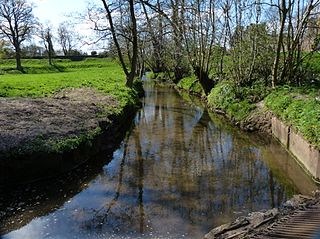
The Finham Brook is a lower tributary of the River Sowe, it flows through Kenilworth and Warwickshire, England, to join the Sowe near Finham. Its principal tributaries include the Canley Brook, which drains the Tile Hill and Canley areas of Coventry, and the Inchford Brook which rises near Beausale, and then flows in an arc through the parish of Beausale, Haseley, Honiley and Wroxall. The length of the Finham and Inchford brooks is 15 miles (24 km), which have a total catchment area of 71 square kilometres (27 sq mi).
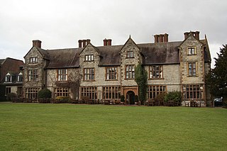
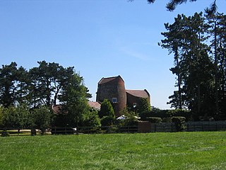
Haseley Manor is a Grade II-listed English country house in Haseley, Warwickshire, England.

Chillerton and Gatcombe is a civil parish on the Isle of Wight, England, including the two villages of Chillerton and Gatcombe. It was previously the parish of Gatcombe but was renamed in 2013 under a 2011 order of Isle of Wight Council.
References
- ↑ Census 2001
- ↑ "civil parish population 2011" . Retrieved 23 December 2015.
- ↑ Historic England. "HASELEY MANOR, Beausale, Haseley, Honiley and Wroxall (1035207)". National Heritage List for England . Retrieved 21 July 2019.
Coordinates: 52°20′N1°39′W / 52.33°N 1.65°W
| | This Warwickshire location article is a stub. You can help Wikipedia by expanding it. |