
Richmond Creek is a major stream in Staten Island, New York City. Its upper drainage basin includes the remote forested hills in the center of the island. It empties into the Fresh Kills.

Newtown Creek, a 3.5-mile (6-kilometer) long tributary of the East River, is an estuary that forms part of the border between the boroughs of Brooklyn and Queens, in New York City. Channelization made it one of the most heavily-used bodies of water in the Port of New York and New Jersey and thus one of the most polluted industrial sites in the United States, containing years of discarded toxins, an estimated 30,000,000 US gallons of spilled oil, including the Greenpoint oil spill, raw sewage from New York City's sewer system, and other accumulation from a total of 1,491 sites.
South Jamaica is a residential neighborhood in the borough of Queens in New York City, located south of downtown Jamaica. Although a proper border has not been established, the neighborhood is a subsection of greater Jamaica bounded by the Long Island Rail Road Main Line tracks, Jamaica Avenue, or Liberty Avenue to the north; the Van Wyck Expressway on the west; Rockaway Boulevard on the south; and Merrick Boulevard on the east, adjoining the neighboring community of St. Albans. Other primary thoroughfares of South Jamaica include Baisley, Foch, Linden, Guy R. Brewer, and Sutphin Boulevards. The 180th Street Business Improvement District is responsible for the development of the area.
Hawtree Creek is a small saltwater creek that empties into Jamaica Bay in Queens, New York. The creek separates the neighborhoods of Hamilton Beach and Howard Beach.

Kissena Park is a 235-acre (95 ha) park located in the neighborhood of Flushing in Queens, New York City. It is located along the subterranean Kissena Creek, which flows into the Flushing River. It is bordered on the west by Kissena Boulevard; on the north by Rose, Oak, Underhill, and Lithonia Avenues; on the east by Fresh Meadow Lane; and on the south by Booth Memorial Avenue. The park contains the city's only remaining velodrome, a lake of the same name, two war memorials, and various playgrounds and sports fields.
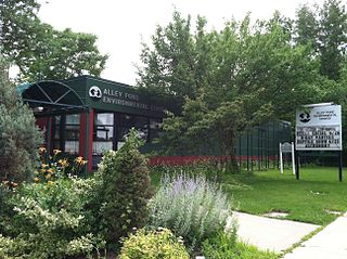
Alley Pond Park is the second-largest public park in Queens, New York City, occupying 655.3 acres (265.2 ha). The park is bordered to the east by Douglaston, to the west by Bayside, to the north by Little Neck Bay, and to the south by Union Turnpike. The Cross Island Parkway travels north-south through the park, while the Long Island Expressway and Grand Central Parkway travel east-west through the park. The park primarily consists of woodlands south of the Long Island Expressway and meadowlands north of the expressway. It is run and operated by the New York City Department of Parks and Recreation.

The Flushing River, also known as Flushing Creek, is a waterway that flows northward through the borough of Queens in New York City, mostly within Flushing Meadows–Corona Park, emptying into the Flushing Bay and the East River. The river runs through a valley that may have been a larger riverbed before the last Ice Age, and it divides Queens into western and eastern halves. Until the 20th century, the Flushing Creek was fed by three tributaries: Mill Creek and Kissena Creek on the eastern bank, and Horse Brook on the western bank.
Westchester Creek is a tidal inlet of the East River located in the south eastern portion of the Bronx in New York City. It is 2.1 miles (3.39 km) in length. The creek formerly traveled further inland, to what is now Pelham Parkway, extending almost to Eastchester Bay and making Throggs Neck into an island during heavy storms. However, much of the route has been filled in, replaced by such structures as the New York City Subway's Westchester Yard and the Hutchinson Metro Center. Westchester Creek's present-day head is at Herbert H. Lehman High School; the remaining portion is largely inaccessible and surrounded by industrial enterprises or empty lots. Westchester Creek is traversed by the Bruckner Interchange at about its midpoint.

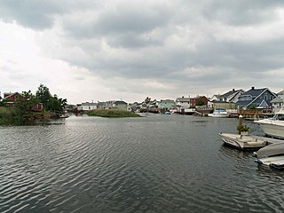
Paerdegat Basin is a channel that connects to Jamaica Bay between the neighborhoods of Bergen Beach and Canarsie in southeast Brooklyn, New York, United States. It connects to Jamaica Bay to the south, and the north end of the basin is adjacent to the intersection of Ralph Avenue and Flatlands Avenue. "Paerdegat" derives from the old Dutch paardengat, meaning "horse gate".
The JFK Expressway is a freeway connecting the Belt Parkway with John F. Kennedy International Airport in Queens, New York City. It interchanges with the Nassau Expressway near the originally proposed southern terminus of the Clearview Expressway. The highway is the newest expressway in New York City, with the final section having been completed in December 1991.
Spring Creek, previously called Spring Creek Basin, is a neighborhood within the East New York section of Brooklyn in New York City. It roughly comprises the southern portions of East New York between Flatlands Avenue to the north, and Jamaica Bay and the Gateway National Recreation Area to the south, with the Brooklyn neighborhood of Canarsie to the west and the Queens neighborhood of Howard Beach to the east. It is named after Spring Creek, one of several creeks that formerly ran through the area and drained into Jamaica Bay.

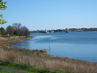
Bowery Bay is a bay off the East River in New York City. It is located near the Ditmars Steinway area in the neighborhood of Astoria in the New York City borough of Queens. It is bordered on the west by the Bowery Bay Water Pollution Control Plant and on the south and east by LaGuardia Airport.
Baisley Pond Park is a public park located in the southeastern part of Queens, New York City, bordering the neighborhoods of South Jamaica, Rochdale, and St. Albans. It covers 109.61 acres (44.36 ha), including the 30-acre (12 ha) Baisley Pond in the center of the park. It is maintained by the New York City Department of Parks and Recreation.

Kissena Creek is a buried stream located in the neighborhoods of Flushing, Fresh Meadows, Hillcrest, and Kew Gardens Hills in the New York City borough of Queens. Kissena Creek originates in a now-filled swamp within Kew Gardens Hills and Pomonok in central Queens, flowing east to Hillcrest. The creek then travels mostly north and west, largely flowing beneath Kissena Park Golf Course, Kissena Park, Kissena Corridor Park, and Queens Botanical Garden, before merging with the Flushing River in Flushing Meadows–Corona Park.
Mussel Island was an island in Newtown Creek located near its confluence with Maspeth Creek, between the Brooklyn neighborhood of Greenpoint and the Queens neighborhood of Maspeth in New York City.

Strack Pond is a glacial kettle pond located inside Forest Park, Queens, New York City. The pond was buried in 1966 and restored four decades later.
Linden Park, officially known as Park of the Americas, is a 3.08-acre (1.25 ha) park located in the center of the Corona neighborhood of Queens, New York City. It has stood out as a green square block on maps since the village of West Flushing was first mapped out in 1853, long before the village became the suburb or urban neighborhood known as Corona.
Potamogeton Pond, a small pond in Queens, New York City, is located on a narrow strip of parkland in Hollis Hills alongside Grand Central Parkway and named after an aquatic plant. It was once a stop on a bridle trail that connected Cunningham Park to Alley Pond Park; but when local stables closed, the trail became disused. The pond can be found at 86th Avenue and 217th Street. The completion of Grand Central Parkway reduced the amount of water that fed the pond, resulting in less water intake and converting the once popular ice-skating site to a bog. The perch, carp, and catfish that lived in the pond died off in 1963 as the parkway was widened in conjunction with the world's fair taking place in Flushing Meadows the following year. Silt covered up the pond, and plants grew atop its former surface.

Captain Tilly Park is a 9.16-acre (3.71 ha) park in Jamaica Hills, Queens, New York, north of downtown Jamaica. It is bordered by 165th Street to the west, 85th Avenue to the north, Chapin Parkway and Gothic Drive to the northeast, and Highland Avenue to the south. The park consists of a kettle pond named Goose Pond, the only remaining kettle pond in Jamaica Hills.

Sunswick Creek is a buried stream located in Astoria and Long Island City, in the northwestern portion of Queens in New York City. It originated to the north of Queensboro Bridge and Queens Plaza in Long Island City, flowing north to the present-day site of the Socrates Sculpture Park in Astoria, and emptying into the East River. The creek was named for a term in the Algonquin language that likely means "Woman Chief" or "Sachem’s Wife."
