Becca Hall

Last updated

Becca Hall Becca Hall - geograph.org.uk - 54545.jpg
Becca Hall

Becca Hall is a country residence situated in Aberford, Leeds, West Yorkshire, Yorkshire, at OS grid reference Lat.53:50:35N Lon.1:22:08W. It is situated on Becca Lane within the old Gascoigne estate. The house is a Grade II listed building. [1]

Contents

Etymology

The name of Becca Hall is first attested in 1189, in the cartulary of Nostell Priory, simply as Becca. This is thought to come from the Old English word bæce ('beck'), itself a loan-word from Old Norse bekkr (meaning the same). The beck in question is probably the Cock Beck. From 1244 into at least the eighteenth century, however, the name is usually attested in forms with a second element derived from Old English haga ('hedge, enclosure'), in spellings such as Bethaye, Bekhaw, and Bekhaghe. Thus the name in this form meant 'enclosure by the beck'. The name Beckhay Hall is first attested in 1716. The modern form Becca Hall is a reduced form of this name. [2]

History

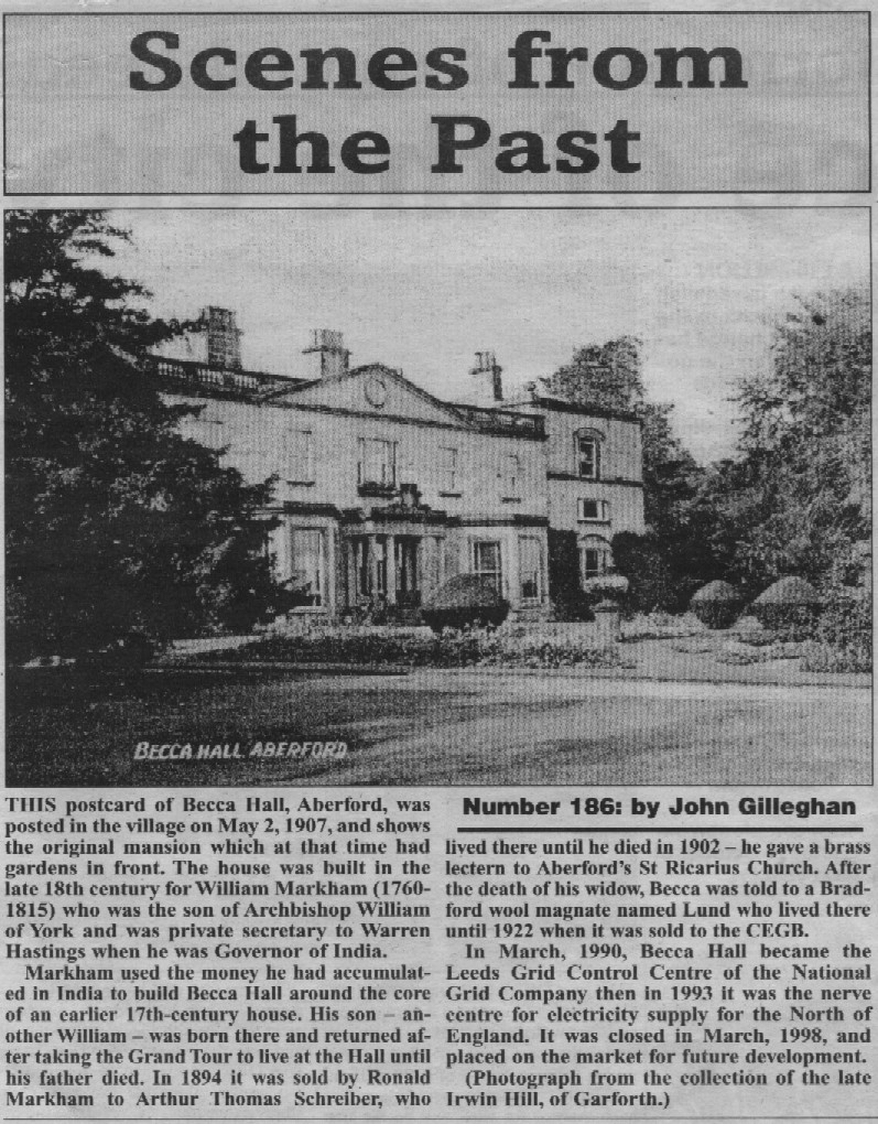
The house was built in 1783 for William Markham, the son of William Markham, Archbishop of York and the private secretary to Warren Hastings. It descended in the Markham family for several generations until it was sold in 1894 by Ronald Markham to Arthur Thomas Schreiber, who lived there until his death in 1902. His widow remained at the hall until her own death in 1907, when it was sold to a Bradford wool magnate Frederick James Lund, who lived there until 1922. [3] It was then sold to Thomas Percy Fawcett, a maltster from Castleford, whose family owned the house until 1949, when it was bought by the Thompson family. In 1958 it was bought by the Central Electricity Generating Board (CEGB). [4]

Following the privatisation of the UK electricity industry in 1989, ownership of the property passed to the National Grid Company. It was used to house the Leeds Grid Control Centre for the UK's electricity transmission network from 1958 until its operational closure in 1997. Advances in communications technology (including remote substation operation) during this period reduced the requirement for regional control centres. By the time of its operational closure in 1997, the entire electricity transmission network in England and Wales could be controlled from a single control room anywhere in the country. Later used as a control centre, it performed as one of the control centres for the Dinorwig hydroelectric storage facility in North Wales.

After being relinquished by the National Grid, the house passed through the hands of a series of would-be developers with various plans, all of which came to nothing. [5] An application for planning permission to develop the building for use as a training centre was refused in September 2004, on the grounds that the development would be unsustainable and would affect local use of the area due to parking requirements. During this period it was however sometimes used for social functions.

In 2011 the house was placed on the market again, [6] and this time was bought by Lara Grylls, the sister of Bear Grylls, and her husband James Fawcett, great-grandson of its previous owner in the 1920s. [5] The couple demolished the extension that had been added by the CEGB to the back of the building (dubbed by them "the tumour"), which had included office buildings, control centres, bunkers and a tower, [7] amounting to four times the size of the original house in all. The demolition process turned out to be self-financing, due to the value of the electrical scrap that was recovered, and even generated a small surplus, which paid for the reinstatement of period windows and chimneys. [5]

Pollution levels

During 2000, Becca Hall was used to measure background levels of air pollution. The site's rural nature places it 1.2 miles (2 km) due west from the A1 and over 3.5 miles (6 km) due east from the edge of the Leeds urban boundary, and so was ideal for that purpose. The only pollutant recorded was ground-level ozone, compared to levels of SO2, NO2, and PM10s at a site next to the A1.

Related Research Articles

<span class="mw-page-title-main">Esholt</span> Village in West Yorkshire, England

Esholt is a village between Shipley and Guiseley, in the metropolitan district of the City of Bradford, West Yorkshire, England. It is situated 3 miles (4.8 km) east of Shipley town centre, 1.5 miles (2.4 km) south-west of Guiseley Main Street, 7 miles (11 km) north of Bradford City Centre, and 10 miles (16 km) north-west of Millennium Square, Leeds.

The Central Electricity Generating Board (CEGB) was responsible for electricity generation, transmission and bulk sales in England and Wales from 1958 until privatisation of the electricity industry in the 1990s.

<span class="mw-page-title-main">Cookridge</span> Suburb of Leeds in West Yorkshire, England

Cookridge is a suburb of north-west Leeds, West Yorkshire, England, north of the Leeds Outer Ring Road. In 1715 Ralph Thoresby described it as a village four miles from Leeds and three from Otley, dating from 1540.

<span class="mw-page-title-main">Weetwood</span> Suburb of Leeds in West Yorkshire, England

Weetwood is an area between Headingley and Meanwood in north-west Leeds, West Yorkshire, England. It is bounded on the north by the A6120, on the west by the A660, on the east by Meanwood Beck and to the south by Hollin Lane. Weetwood Lane runs north and south through it.

<span class="mw-page-title-main">Aberford</span> Village and civil parish near Leeds, West Yorkshire, England

Aberford is a village and civil parish on the eastern outskirts of the City of Leeds metropolitan borough in Yorkshire, United Kingdom. It had a population of 1,059 at the 2001 census, increasing to 1,180 at the 2011 Census. It is situated 10 miles (15.5 km) east, north east of Leeds city centre in the LS25 Leeds postcode area.

<span class="mw-page-title-main">Lotherton Hall</span> Country house in West Yorkshire, England

Lotherton Hall is a country house near Aberford, West Yorkshire, England. It lies a short distance from the A1(M) motorway, 200 miles (320 km) equidistant between London and Edinburgh. It is one of nine sites in the Leeds Museums & Galleries group.

<span class="mw-page-title-main">Cock Beck</span> Stream in West Yorkshire, England

Cock Beck is a stream in the outlying areas of East Leeds, West Yorkshire, England, which runs from its source due to a runoff north-west of Whinmoor, skirting east of Swarcliffe and Manston, past Pendas Fields, Scholes, Barwick-in-Elmet, Aberford, Towton, Stutton, and Tadcaster, where it flows into the River Wharfe.

<span class="mw-page-title-main">Barwick-in-Elmet</span> Village in West Yorkshire, England

Barwick-in-Elmet is a village in West Yorkshire, 7 miles (11 km) east of Leeds city centre. It is one of only three places in the area to be explicitly associated with the ancient Romano-British kingdom of Elmet, the others being Scholes-in-Elmet and Sherburn-in-Elmet.

<span class="mw-page-title-main">Hartlepool nuclear power station</span> Nuclear power station in Hartlepool, England

Hartlepool nuclear power station is a nuclear power station situated on the northern bank of the mouth of the River Tees, 2.5 mi south of Hartlepool in County Durham, North East England. The station has a net electrical output of 1,185 megawatts, which is 2% of Great Britain's peak electricity demand of 60 GW. Electricity is produced through the use of two advanced gas-cooled reactors (AGR). Hartlepool was only the third nuclear power station in the United Kingdom to use AGR technology. It was also the first nuclear power station to be built close to a major urban area.

<span class="mw-page-title-main">Skyrack</span> Wapentake of the West Riding of Yorkshire, England

Skyrack was a wapentake of the West Riding of Yorkshire, England. It was split into upper and lower divisions and centred in Headingley, Leeds. The Lower Division included the parishes of Aberford, Bardsey, Barwick-in-Elmet, Kippax, Thorner, Whitkirk and part of Harewood, while the Upper Division included the parishes of Adel, Bingley, Guiseley and parts of Harewood, Ilkley and Otley.

<span class="mw-page-title-main">Swillington</span> Village and civil parish in West Yorkshire, England

Swillington is a village and civil parish near Leeds, West Yorkshire, England, in the City of Leeds metropolitan borough. It is situated 5 miles (8 km) east from Leeds city centre, north of the River Aire, and is surrounded by streams including Fleakingley Beck. In 2001, Swillington had a population of about 3,530, reducing to 3,381 at the 2011 Census.

<span class="mw-page-title-main">Aberford Dykes</span> Series of archaeological earthworks

The Aberford Dykes are a series of archaeological monuments located around the valley of the Cock Beck, where it runs just north of the village of Aberford on the border between North and West Yorkshire, England.

<span class="mw-page-title-main">Dunston Power Station</span> Coal-fired power station in England

Dunston Power Station refers to a pair of adjacent coal-fired power stations in the North East of England, now demolished. They were built on the south bank of the River Tyne, in the western outskirts of Dunston in Gateshead. The two stations were built on a site which is now occupied by the MetroCentre. The first power station built on the site was known as Dunston A Power Station, and the second, which gradually replaced it between 1933 and 1950, was known as Dunston B Power Station. The A Station was, in its time, one of the largest in the country, and as well as burning coal had early open cycle gas turbine units. The B Station was the first of a new power station design, and stood as a landmark on the Tyne for over 50 years. From the A Station's opening in 1910 until the B Station's demolition in 1986, they collectively operated from the early days of electricity generation in the United Kingdom, through the industry's nationalisation, and until a decade before its privatisation.

<span class="mw-page-title-main">Roosecote Power Station</span>

Roosecote Power Station was a gas-fired, originally coal-fired power station, situated in the Roosecote district of Barrow-in-Furness in Cumbria, North West England. The gas-fired station opened in 1991 and was the first CCGT power station to supply electricity to the United Kingdom's National Grid, but was mothballed in 2012 after a proposed biomass power station was cancelled. It was situated directly adjacent to Rampside Gas Terminal. The plant was demolished between 2014 and 2015. The site is now a 49 MW battery storage facility.

<span class="mw-page-title-main">Northfleet Power Station</span>

Northfleet Power Station was a coal-fired, later oil-fired, power station on the south bank of the Thames at Northfleet, Kent. Opened in 1963, it was converted to burn oil in 1972, and closed in 1991.

<span class="mw-page-title-main">Northampton Power Station</span> Former electricity generating station

Northampton power station was an electricity generating station in Northampton, Northamptonshire, England, which began operation for the Northampton Electric Light and Power Company Limited (NELPC) in 1919 and generated power until closure in 1976.

<span class="mw-page-title-main">Huncoat Power Station</span> Former electricity generating station

Huncoat Power Station was located in Huncoat near Accrington, Lancashire. It was a 150 MW, coal-fired, electricity generating station in operation from 1952 to 1984. It has since been demolished. Huncoat power station replaced the earlier Accrington power station that had supplied electricity to the town since 1900.

Huddersfield power station supplied electricity to the town of Huddersfield and the wider area from 1893 to 1981. It was owned and operated by Huddersfield Corporation until the nationalisation of the electricity supply industry in 1948. The power station was redeveloped several times: including the incorporation of new plant in the 1910s, and in the 1930s to 1950s. The station was decommissioned in October 1981.

Leeds power station, also known as Whitehall Road power station, supplied electricity to the city of Leeds and the surrounding area from 1893 to 1965. It was initially built, owned and operated by the Yorkshire House-to-House Electricity Company Limited. Leeds Corporation took over the electricity undertaking in 1898 and generated and distributed electricity until the nationalisation of the British electricity supply industry in 1948. The power station was redeveloped several times to meet increasing demand for electricity.

Aberford and Lotherton cum Aberford are adjacent civil parishes in the metropolitan borough of the City of Leeds, West Yorkshire, England. The parishes contain 25 listed buildings that are recorded in the National Heritage List for England. Of these, one is listed at Grade II*, the middle of the three grades, and the others are at Grade II, the lowest grade. The parishes contain the village of Aberford and the surrounding countryside, including the area around Lotherton Hall. Most of the listed buildings are houses and cottages, and the others include churches, a market cross, a former water mill and a former windmill, a bridge, farm buildings, a hotel and a former stable block, a war memorial, and three milestones.

References

  1. Historic England. "Becca Hall (house only) at SE419387 (1135648)". National Heritage List for England . Retrieved 25 June 2019.
  2. Harry Parkin, Your City's Place-Names: Leeds, English Place-Name Society City-Names Series, 3 (Nottingham: English Place-Names Society, 2017), pp. 22-23.
  3. "Scenes from the past-Becca Hall". Aberford.net. Retrieved 30 March 2013.
  4. Becca Hall Archived 2012-03-19 at the Wayback Machine , BBC Domesday project, 1986
  5. 1 2 3 Becca surges back to life, Yorkshire Post , 6 June 2015
  6. 8 bedroom detached house for sale, Rightmove, 24 March 2011
  7. Former CEGB Control Centre, Becca Hall, Aberford, West Yorkshire: Building Recording, Ed Dennison Archaeological Services Ltd, October 2012. Via Archaeology Data Service, University of York

Coordinates: 53°50′28″N1°22′15″W / 53.84110°N 1.37079°W / 53.84110; -1.37079