Related Research Articles

The River Great Ouse is a river in England, the longest of several British rivers called "Ouse". From Syresham in Northamptonshire, the Great Ouse flows through Buckinghamshire, Bedfordshire, Cambridgeshire and Norfolk to drain into the Wash and the North Sea near Kings Lynn. Authorities disagree both on the river's source and its length with one quoting 160 mi (260 km) and another 143 mi (230 km). Mostly flowing north and east, it is the fifth longest river in the United Kingdom. The Great Ouse has been historically important for commercial navigation, and for draining the low-lying region through which it flows; its best-known tributary is the Cam, which runs through Cambridge. Its lower course passes through drained wetlands and fens and has been extensively modified, or channelised, to relieve flooding and provide a better route for barge traffic. The unmodified river would have changed course regularly after floods.

The Fens, also known as the Fenlands, in eastern England are a naturally marshy region supporting a rich ecology and numerous species. Most of the fens were drained centuries ago, resulting in a flat, dry, low-lying agricultural region supported by a system of drainage channels and man-made rivers and automated pumping stations. There have been unintended consequences to this reclamation, as the land level has continued to sink and the dykes have been built higher to protect it from flooding.

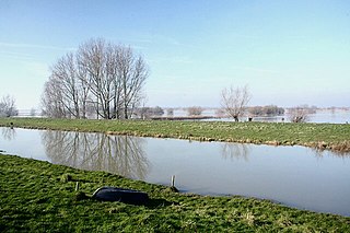
The Old Bedford River is an artificial, partial diversion of the waters of the River Great Ouse in the Fens of Cambridgeshire, England. It was named after the fourth Earl of Bedford who contracted with the local Commission of Sewers to drain the Great Level of the Fens beginning in 1630. It provided a steeper and shorter path for the waters of the Great Ouse, and was embanked to prevent them flooding the low ground of the South Fens. Throughout the project, the Earl and his Adventurers faced disruption from those who were opposed to drainage schemes. The project was deemed to have succeeded in draining the fens in 1637, but that decision was reversed in 1638. After a lull during the English Civil War, when much of the work was damaged, the Dutch engineer Cornelius Vermuyden worked with William Russell, the fifth Earl of Bedford to complete the drainage. Disruption and unrest continued while the work was carried out, resulting in the Adventurers employing armed guards. A second river, the New Bedford River, was cut parallel to the first channel, which then became the Old Bedford River. At some point, the Old Bedford River was split into two parts, when the upper section was diverted into the River Delph at Welches Dam, and the lower section was joined to the Counter Drain. Both parts retain the name, but are not connected to each other. The area between the two Bedford rivers acts as a large washland, which holds floodwater when the river channels cannot cope with the volume of water in them.
The New Bedford River, also known as the Hundred Foot Drain because of the distance between the tops of the two embankments on either side of the river, is a navigable man-made cut-off or by-pass channel of the River Great Ouse in the Fens of Cambridgeshire, England. It provides an almost straight channel between Earith and Denver Sluices. It is tidal, with reverse tidal flow being clearly visible at Welney, some 19 miles (31 km) from the sea.
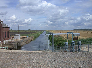
Prickwillow is a village in East Cambridgeshire with an estimated population of 440. Originally a small hamlet on the banks of the River Great Ouse, it is now on the banks of the River Lark since re-organisation of the river system. It lies in the south of the Fens, 4 miles (6.4 km) east of the city of Ely in Cambridgeshire, England, and is home to Prickwillow Museum, which tells the story of the changing face of Fenland. Prickwillow Museum is housed in the old pumping station and contains a major collection of working pumping engines. The village is also home to the Ely Group of Internal Drainage Boards.

Community boards of Brooklyn are New York City community boards in the borough of Brooklyn, which are the appointed advisory groups of the community districts that advise on land use and zoning, participate in the city budget process, and address service delivery in their district.
River boards were authorities who controlled land drainage, fisheries and river pollution and had other functions relating to rivers, streams and inland waters in England and Wales between 1950 and 1965.
River authorities controlled land drainage, fisheries and river pollution in rivers, streams and inland waters in England and Wales between 1965 and 1973.
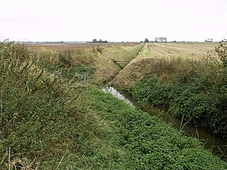
Burnt Fen is an area of low-lying land crossed by the A1101 road between Littleport in Cambridgeshire and Mildenhall in Suffolk, England. It is surrounded on three sides by rivers, and consists of prime agricultural land, with sparse settlement. It is dependent on pumped drainage to prevent it from flooding.
In the Netherlands, a water board, water council or water authority is a regional governing body solely charged with the management of surface water in the environment. Water boards are independent of administrative governing bodies like provinces and municipalities. In general, they are responsible for managing rivers and canals, issues with the flow of watercourses and drainage issues, water collection, flood and erosion prevention and provision of potable water. They manage polder systems, water levels, water barriers and locks, enforcements, water quality and sewage treatment in their respective regions. The concept of a coordinating "High Water Authority" (Hoogheemraadschap) originated in what now is the province of South Holland in the 12th century.

An internal drainage board (IDB) is a type of operating authority which is established in areas of special drainage need in England and Wales with permissive powers to undertake work to secure clean water drainage and water level management within drainage districts. The area of an IDB is not determined by county or metropolitan council boundaries, but by water catchment areas within a given region. IDBs are geographically concentrated in the Broads, Fens in East Anglia and Lincolnshire, Somerset Levels and Yorkshire.
The Association of Drainage Authorities (ADA) is a membership body for internal drainage boards and other stakeholders in water level management in the United Kingdom.

The Middle Level Commissioners are a land drainage authority in eastern England. The body was formed in 1862, undertaking the main water level management function within the Middle Level following the breakup of the former Bedford Level Corporation.
The River Foulness is a river in the East Riding of Yorkshire, England. Its name is derived from Old English fūle[n] ēa, meaning “dirty water”. Maintenance responsibilities for the river transferred from the Environment Agency to the Market Weighton Drainage Board on 1 October 2011. Market Weighton Drainage Board subsequently amalgamated with the Lower Ouse Internal Drainage Board on 1 April 2012 to create the Ouse and Humber Drainage Board. The river discharges into the Humber Estuary via Market Weighton Canal. Water levels within the river, its tributaries and the canal are managed and controlled by the Environment Agency. The river lies in an area known as the Humberhead Levels.
The Land Drainage Act 1930 was an Act of Parliament passed by the United Kingdom Government which provided a new set of administrative structures to ensure that drainage of low-lying land could be managed effectively. It followed the proposals of a royal commission which sat during 1927.

The Land Drainage Act 1961 was an Act of Parliament passed by the United Kingdom Government which provided mechanisms for river boards to raise additional finance to fund their obligations. It built upon the provisions of the Land Drainage Act 1930 and the River Boards Act 1948.

Holderness Drain is the main feature of a Land Drainage scheme for the area of Holderness to the east of the River Hull in the East Riding of Yorkshire, England. Construction began in 1764, and several notable civil engineers were involved with the scheme over the years. Despite the high costs of the initial scheme, it was not particularly successful, because of the refusal of the ship owners of Hull to allow an outlet at Marfleet. They insisted that the water be discharged into the River Hull to keep the channel free of silt. Following a period of agricultural depression and the building of new docks in the early 1800s, an outlet at Marfleet was finally authorised in 1832. A high level system still fed upland water to the Hull, but the low level system discharged into the Humber, where levels were considerably lower. Following the success of steam pumping on the Beverley and Barmston Drain, the trustees looked at such a possibility for the Holderness Drain, but the development of the Alexandra Dock in the 1880s and then the King George V Dock in 1913 provided a solution, as the docks were topped up with water pumped from the drain, to lessen the ingress of silt-laden water.
The Bedford Level Corporation was founded in England in 1663 to manage the draining of the Fens of East Central England. It formalised the legal status of the Company of Adventurers previously formed by the Duke of Bedford to reclaim 95,000 acres of the Bedford Level.
The River Boards Act 1948 was an Act of Parliament passed by the United Kingdom Government which provided constitutional, financial and general administrative structures for river boards, which were responsible for the management of river board areas, and superseded the catchment boards that had been set up under the Land Drainage Act 1930.

The Upper Witham IDB is an English Internal Drainage Board responsible for land drainage and the management of flood risk for an area to the west of the Lincolnshire city of Lincoln, broadly following the valleys of the upper River Witham, the River Till and the course of the Fossdyke Navigation.