Related Research Articles

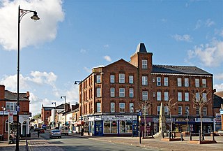
Leigh is a town in the Metropolitan Borough of Wigan, Greater Manchester, England, on low-lying land northwest of Chat Moss.

Astley is a village in the Metropolitan Borough of Wigan, Greater Manchester, England. Within the boundaries of the historic county of Lancashire, it is crossed by the Bridgewater Canal and the A580 East Lancashire Road. Continuous with Tyldesley, it is equidistant from Wigan and Manchester, both 8.3 miles (13.4 km) away. Astley Mosley Common ward had a population of 11,270 at the 2011 Census.
Tyldesley is a market town in Metropolitan Borough of Wigan in Greater Manchester, England. Within the boundaries of the historic county of Lancashire, it is north of Chat Moss near the foothills of the West Pennine Moors, 8 miles (12.9 km) southeast of Wigan and 9 miles (14.5 km) northwest of Manchester. At the United Kingdom Census 2001, the Tyldesley built-up area subdivision, excluding Shakerley, had a population of 16,142.
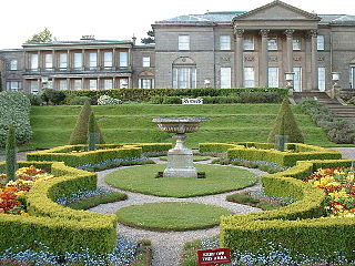
Tatton Park is a historic estate in Cheshire, England, north of the town of Knutsford. It contains a mansion, Tatton Hall, a medieval manor house, Tatton Old Hall, Tatton Park Gardens, a farm and a deer park of 2,000 acres (8.1 km2). It is a popular visitor attraction and hosts over a hundred events annually. The estate is owned by the National Trust, and managed under lease by Cheshire East Council . Since 1999, it has hosted North West England's annual Royal Horticultural Society flower show.
Brandlesholme is a suburb north of Bury in Greater Manchester, England, half-way between Bury town centre and Ramsbottom.

Northill is a village and civil parish in the Central Bedfordshire district of the county of Bedfordshire, England about 6.5 miles (10 km) southeast of the county town of Bedford.

Swanton Morley is a village and civil parish situated in the English county of Norfolk. It is situated in the heart of Norfolk 18 miles from the centre of Norwich and three miles from Dereham, at the geographical centre of Norfolk. It covers an area of 11.14 km2 (4.30 sq mi) and had a population of 2,415 in 783 households at the 2001 census, reducing to a population of 2,100 in 723 households at the 2011 Census. For the purposes of local government it is in the Elmham and Mattishall Division of Norfolk County Council and the Lincoln Ward of Breckland District Council.

Aston Eyre Hall is an unfortified stone manor house at Aston Eyre near Bridgnorth in the English county of Shropshire, United Kingdom. It is a Grade II* listed building.

Baguley Hall is a 14th-century timber-framed building in Baguley, Greater Manchester, North West England.
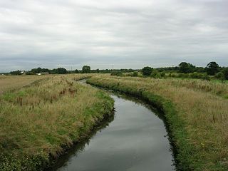
The Glaze Brook, or River Glaze, is a minor river in the River Mersey catchment area, England. From Hope Carr to the River Mersey it forms the county boundary with Cheshire. It is about 22 miles (35 km) long and its main tributaries are the Astley, Bedford, Hey, Pennington, Shaw and Westleigh Brooks.
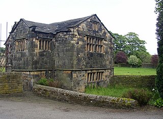
Old Manor Farm is a 15th-century hall in Marple, in the Metropolitan Borough of Stockport, Greater Manchester, England. Built in the 15th century, it has had additions made in the 16th, 17th and 20th centuries. Called "one of the finest existing examples of a small medieval manor house in Lancashire or Cheshire", it is a Grade II* listed building.
Lower Caldecote is a hamlet in the civil parish of Northill and part of the Central Bedfordshire district of Bedfordshire, England. The county town of Bedford is 7.5 miles (12 km) to the west.
Kirklees Priory was a Cistercian nunnery whose site is in the present-day Kirklees Park, Clifton near Brighouse, Calderdale, West Yorkshire, England. It was originally in the ancient ecclesiastical parish of Dewsbury. The priory dedicated to the Virgin Mary and St James was founded by Reiner le Fleming, Lord of the manor of Wath upon Dearne, in 1155 during the reign of Henry II.

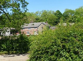
Bedford, a suburb of Leigh, Greater Manchester is one of three ancient townships, Bedford, Pennington and Westleigh, that merged in 1875 to form the town of Leigh. Historically, Bedford was in Lancashire.

Morleys Hall, a moated hall converted to two houses, is situated at grid reference SJ 689 992 on Morleys Lane, on the edge of Astley Moss in Astley in the historic county of Lancashire and the ceremonial county of Greater Manchester, England. It was largely rebuilt in the 19th century on the site of a medieval timber house. The hall is a Grade II* listed building and the moat a scheduled ancient monument. Morleys is a private residence.

Damhouse or Astley Hall is a Grade II* Listed building in Astley, Greater Manchester, England. It has served as a manor house, sanatorium, and, since restoration in 2000, houses offices, a clinic, nursery and tearooms.

St Joseph's Church is an active Roman Catholic church on Chapel Street in Bedford, Leigh in Greater Manchester, England. It is in the parish of St Edmund Arrowsmith. It has been designated by English Heritage as a Grade II listed building.
Garrett Hall or The Garrett is a former manor house and now a grade II listed farmhouse in Tyldesley, Greater Manchester, England. The hall was designated a grade II listed building in 1987.
Chaddock Hall was an ancient hall on Chaddock Lane in Tyldesley, Greater Manchester, England. It was designated a Grade II listed building in 1966. It was gutted in an arson attack in 2014.

Brightholmlee is a small rural hamlet situated within the City of Sheffield in England. The hamlet falls within the Stannington Ward of the City. It is located 6.2 miles (10 km) north-west of the city centre and 0.6 miles (1 km) west of Wharncliffe Side within Bradfield Parish. Previously a farming community, it consist of four farmsteads, Manor Farm, Old Hall Farm, High Lea Farm and Lee Farm. It is now almost entirely residential with the last working farm being sold for development in 2013.
References
Citations
- ↑ Historic England, "Bedford Hall (1356220)", National Heritage List for England , retrieved 5 April 2012
- ↑ Farrer, William; Brownbill, J, eds. (1907), "Bedford", A History of the County of Lancaster: Volume 3, British History Online, pp. 431–435, retrieved 5 April 2012
- ↑ "BEDFORD HALL, HOOTEN LANE". Historic England. Retrieved 9 April 2023.