Related Research Articles
Upton is a hamlet in the civil parish of Dinton-with-Ford and Upton, in Buckinghamshire, England. It is located to the north of the main village of Dinton, on the junction between the new road from Aylesbury to Thame, and the old road before it was rerouted.

Cotes is a hamlet and very small civil parish near the town of Loughborough in Leicestershire, England.Cotes has a population of about 50. At the 2011 census the population remained less than 100 and was included in the civil parish of Burton on the Wolds.

Brown Clee Hill is the highest hill in the rural English county of Shropshire, at 540 metres (1,770 ft) above sea level. It is one of the Clee Hills, and is in the Shropshire Hills Area of Outstanding Natural Beauty.

The Shropshire Hills area, in the English county of Shropshire, is designated as an Area of Outstanding Natural Beauty (AONB). It is located in the south of the county, extending to its border with Wales. Designated in 1958, the area encompasses 802 square kilometres (310 sq mi) of land primarily in south-west Shropshire, taking its name from the upland region of the Shropshire Hills. The A49 road and Welsh Marches Railway Line bisect the area north-south, passing through or near Shrewsbury, Church Stretton, Craven Arms and Ludlow.

Titterstone Clee Hill, sometimes referred to as Titterstone Clee or, incorrectly, Clee Hill, is a prominent hill in the rural English county of Shropshire, rising at the summit to 533 metres (1,749 ft) above sea level.

The A528 is a route on the UK highway network that runs from Marchwiel, near Wrexham, in North Wales (53.0225°N 2.9597°W), to Shrewsbury, Shropshire, in England (52.7128°N 2.7512°W). On the way it passes through Ellesmere and Coton Hill. The road follows an old route that was Turnpiked in the 18th century.

Known as the Hagley Road in Birmingham, the A456 is a main road in England running between Central Birmingham and Woofferton, Shropshire, south of Ludlow. Some sections of the route, for example Edgbaston near Bearwood, are also the route of the Elan Aqueduct which carries Birmingham's water supply from the Elan Valley.
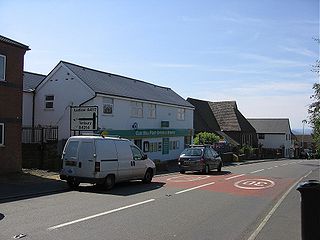
Cleehill is a village in south Shropshire, England. It is sometimes written as Clee Hill Village to avoid confusion. It lies in the civil parish of Caynham. The market towns of Ludlow and Cleobury Mortimer are both 5.5 miles (8.9 km) distant, Ludlow to the west and Cleobury to the east.
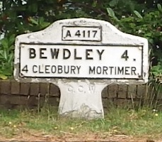
The A4117 is a single-carriageway 'A road' in western England, largely in Shropshire, which passes through part of the Wyre Forest and Clee Hills.
The Clee Hills are a range of hills in Shropshire, England near Ludlow, consisting of Brown Clee Hill 1,772 feet (540 m), the highest peak in Shropshire, and Titterstone Clee Hill 1,749 feet (533 m). They are both in the Shropshire Hills Area of Outstanding Natural Beauty.

Dinedor is a hill, village and civil parish in Herefordshire, England. Dinedor is situated 5 km (3.1 mi) south east of Hereford. The hilltop is the site of Dinedor Camp, an Iron Age fort.
Bitterley is a village and civil parish in Shropshire, England. According to the 2001 census the parish had a population of 802, increasing to 902 at the 2011 Census. The village is about 4 miles (6.4 km) east of Ludlow on the western slopes of Titterstone Clee Hill. Bitterley is the location for Bitterley Court about 0.62 miles (1.00 km) east of the modern village. Nearby to the east, is the small hamlet of Bedlam.
Great Hanwood is a civil parish in Shropshire, England.

Clee Hill Junction was a railway junction in Shropshire, England, where the goods only line from Titterstone Clee Hill joined the Shrewsbury and Hereford Railway, a LNWR/GWR joint line. It was situated 24 chains to the north of Ludlow railway station.
The hamlet of Beacon Hill, is situated off the B474 near Penn and on the outskirts of High Wycombe Buckinghamshire. Nearby is the Golf Course at Wycombe Heights.

Rushbury is a village and civil parish in Shropshire, roughly five miles from Church Stretton and eight miles from Much Wenlock.

Garmond is a linear village in Monquhitter Parish which is located in Aberdeenshire, Scotland. It was founded c.1760. Like the neighbouring villages of Cuminestown and New Byth, the residential part is located on the crest of a hill, the valley below being largely given over to farmland.

Ditton Priors is a village and civil parish in south Shropshire, England.

Caer Caradoc is an Iron Age hill fort and Scheduled Monument in the south-west of the English county of Shropshire, near the town of Clun. It overlooks the village of Chapel Lawn. It is located within an area of Open Access land and can be reached via a public footpath between the farms of Wax Hall to the west and Bryncambric to the east.
Cleeton St Mary is a small village in south Shropshire, England.
References
- 1 2 3 Francis, Peter (2013). Shropshire War Memorials, Sites of Remembrance. YouCaxton Publications. p. 130. ISBN 978-1-909644-11-3.
- ↑ Ordnance Survey: Landranger map sheet 138 Kidderminster & Wyre Forest (Map). Ordnance Survey. 2012. ISBN 9780319228340.
- ↑ "Ordnance Survey: 1:50,000 Scale Gazetteer" (csv (download)). www.ordnancesurvey.co.uk. Ordnance Survey. 1 January 2016. Retrieved 30 January 2016.
Coordinates: 52°23′33″N2°36′44″W / 52.39250°N 2.61222°W
| | This Shropshire location article is a stub. You can help Wikipedia by expanding it. |