This article needs additional citations for verification .(August 2013) |
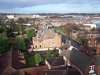
Beechdale, originally named Gypsy Lane Estate, is a housing estate in Walsall, England, that was developed predominantly during the 1950s and 1960s.
This article needs additional citations for verification .(August 2013) |
Beechdale, originally named Gypsy Lane Estate, is a housing estate in Walsall, England, that was developed predominantly during the 1950s and 1960s.
Beechdale Infant School for 5-7 year olds opened on the estate in 1955 in Remington Road, followed by the 7-11 junior school in 1959. These schools later merged to form a single primary school and remained open until July 2006, being demolished in early 2007.
Hatherton Lane Primary School (which originally opened to infants in 1956 and juniors in 1960) is now the only primary school in the area.
Just to the north of the estate is Bloxwich Academy, which opened as Frank F. Harrison Community School in 1965. [1]
Beechdale Football Club, the local football team, play and train on a football pitch within the estate. The team has had considerable success in recent years within its division. There are also popular pool, snooker and darts teams on the estate.[ citation needed ]
Noddy Holder, the lead singer of Slade, grew up on the estate after moving there as a child from Caldmore; his parents were among the estate's original residents in the 1950s. Another famous former resident of the estate are Rob Halford of Judas Priest and Martin Degville of Sigue Sigue Sputnik. [2] [3]
Trolleybuses once ran into the estate when it was originally called Gypsy Lane Estate. Currently all public transport services are provided by bus and operated by National Express West Midlands. [4]

Walsall is a large market town and administrative centre in West Midlands County, England. Historically part of Staffordshire, it is located 9 miles (14 km) north-west of Birmingham, 7 miles (11 km) east of Wolverhampton and 9 miles (14 km) from Lichfield.
Tipton is an industrial town in the West Midlands in England with a population of around 38,777 at the 2011 UK Census. It is located 16 kilometres (9.9 mi) northwest of Birmingham.

Smethwick is an industrial town in Sandwell, West Midlands, England, historically in Staffordshire. It lies four miles west of Birmingham city centre, and borders West Bromwich and Oldbury to the north and west. Formerly a Staffordshire county borough, Smethwick is situated near the edge of Sandwell metropolitan borough and borders the Birmingham districts of Handsworth, Winson Green, Harborne, Edgbaston and Quinton to the south and east, as well as the Black Country towns of West Bromwich and Oldbury in the north and west.

Willenhall is a market town situated in the Metropolitan Borough of Walsall, in the West Midlands, England, with a population taken at the 2011 census of 28,480. It is situated between Wolverhampton and Walsall, historically in the county of Staffordshire. It lies upon the River Tame, and is part of the Black Country.
Bloxwich is a market town in the Metropolitan Borough of Walsall, West Midlands, England, situated in the north of the borough and forming part of the Staffordshire/West Midlands border.

Great Barr is now a large and loosely defined area to the north-west of Birmingham, England. The area was historically in Staffordshire, and the parts now in Birmingham were once known as Perry Barr, which is still the name of an adjacent Birmingham district. Other areas known as Great Barr are in the Metropolitan Boroughs of Walsall and Sandwell.

Ashmore Park is a large housing estate in Wednesfield, England. It has been part of the city of Wolverhampton, West Midlands since 1966, when the majority of Wednesfield was incorporated into Wolverhampton. It constitutes mostly of the Wednesfield North ward of the Wolverhampton council.
Leamore is a mix of private and council housing, built since the late 19th century. The most significant homes in the area are several multi-storey blocks of council flats, which were built in the 1960s.
Moxley is a suburb of Darlaston in the Metropolitan Borough of Walsall, West Midlands County, England. It was first developed during the early part of the 19th century when a handful of terraced houses were built to accommodate locals working in factories and mines and the area was created in 1845 out of land from Darlaston, Bilston and Wednesbury.

Coseley is a village in the north of the Dudley Metropolitan Borough, in the English West Midlands. Part of the Black Country, it is situated approximately three miles north of Dudley itself, on the border with Wolverhampton. Though it is a part of Dudley for statistical and administrative purposes, it is divided between the Bilston and Tipton postal districts, and mostly falls within the Wolverhampton South-East parliamentary constituency.
New Invention is a large village around three miles north of the town of Willenhall and four miles east of the city of Wolverhampton in the Metropolitan Borough of Walsall, West Midlands, England. It is situated halfway between Walsall and Wolverhampton on the busy main A4124 and A462 roads.
Harden is an area to the north of Walsall and borders with Bloxwich, Blakenall Heath, Coalpool, Goscote and Rushall. The whole area was part of the industrial revolution, with mining and metal processing being the main industries. Although close to the A34 main road from the Stoke (potteries) to Birmingham, it is still served by canals.
Bentley is an area in the Metropolitan Borough of Walsall located around Junction 10 of the M6 Motorway. It is also a rural village of houses towards its eastern sides. It shares borders with the areas of Willenhall, Beechdale, Ashmore Park, Pleck, Darlaston and Alumwell.
Park Hall is an affluent area near to the south-eastern edge of Walsall in the West Midlands of England. It is considered that the area near to the local Park Hall Primary and Infant schools and the Gillity Village shops are classed as Park Hall.
Hateley Heath is a residential area of West Bromwich, West Midlands.The population of the Sandwell ward taken at the 2011 census was 14,227.
Pouk Hill is a hill located in Walsall, West Midlands, England.
Walsall Wood is a large village located in the Metropolitan Borough of Walsall, West Midlands, England. Located between Aldridge and Brownhills.
The Lodge Farm estate is located in the area of Short Heath in the town of Willenhall, which is in the Metropolitan Borough of Walsall.

The Walsall trolleybus system once served the town of Walsall, then in Staffordshire, but now in West Midlands, England. Opened on 22 July 1931, it gradually replaced the Walsall Corporation Tramways network.