Belair, South Australia

Last updated

Belair
Adelaide,  South Australia
Windypoint lynton belair.jpg
Part of the view north from Windy Point
Population4,718 (SAL 2021) [1]
Postcode(s) 5052
Area14.58 km2 (5.6 sq mi) [2]
Location10 km (6 mi) S of Adelaide
LGA(s) City of Mitcham
State electorate(s) Waite
Federal division(s) Boothby
Suburbs around Belair:
Lynton
Torrens Park
Mitcham
Brown Hill Creek
Crafers West
Panorama Belair Upper Sturt
Eden Hills Blackwood
Glenalta
Hawthorndene
Upper Sturt

Belair is a suburb in the south eastern foothills of Adelaide, South Australia at the base of the Mount Lofty Ranges.

Contents

Name

Before European settlement, the Kaurna people called the area of modern-day Belair "piraldi". [3] One early European name for the area was Sleep's Hill, named after Samuel Sleep, a shepherd who came to South Australia in the 1830s. [4] The origin of the modern name "Belair" is uncertain. Gustav Ludewigs, who subdivided the area, may have named the suburb after Bel Air, Martinique, being his wife Maria's birthplace. [3] [5] Another theory is that it was named in 1849 after Eugene Bellairs, a Government surveyor who lived in the area. [3]

History

The area was used by the Kaurna and Peramangk people for seasonal hunting and gathering. The trees provided gum resin for food and bark for shelter construction, and possums and bandicoots were hunted for food and for their skins to be used in cloaks. [6]

Government Farm

Old Government House Belair Old Government House.jpg
Old Government House

The first known European settler in Belair was a squatter named Nicholas Foott. Although he did not own any land, the colonial government allowed him to stay in the area and improve the land until the land was required by the government. Foott built a house on the land some time between 1836 and 1840. In July 1840, Governor George Gawler decided to establish a farm in the area named Government Farm, and Foott was asked to leave. [6] From 1858 to 1860, Old Government House was built on the farm as the summer residence for the Governor of South Australia, which it remained until a new house was built at Marble Hill in 1880. [6]

Two petitions, with 620 signatures between them, were presented to the South Australian Parliament in 1878 calling for a railway line to be constructed into the Adelaide Hills. The first petition desired a railway line so that both the rich and the poor living in the Adelaide Plains would be able to access the hills, viewed as the healthiest part of the Adelaide region. The second petition wanted a railway link to Port Adelaide so that produce could be delivered to markets in the hills at the same price as to markets in North Adelaide, which already had a rail link. [6] After a survey of the Adelaide Hills, the Parliament passed a bill enacting a route from Adelaide to Nairne, which would pass through Belair. [6] Construction work on the line began in 1879 and the section of the line through to Aldgate was opened on 14 March 1883. This included service to the Belair railway station, located in Government Farm. [6]

In 1881, the South Australian government proposed subdividing the land of the farm to meet the increasing demand for land in the Adelaide Hills, but this was met with protests. This led to an Act of Parliament being passed in October 1883 prohibiting the sale of Government Farm without the sanction of Parliament. [6] Further campaigns to protect the land during the 1880s, as well as the greater accessibility to the farm due to the construction of the Adelaide to Nairne Railway line, led to Government Farm being transformed into Belair National Park, proclaimed on 19 December 1891 with the passage of the National Park Act. [6]

Later development

Belair Home for Inebriates, c. 1883 Inebriates' Retreat, Belair.jpg
Belair Home for Inebriates, c. 1883

Belair was the location of the first facility for the treatment of alcoholism in South Australia, at the Belair Home for Inebriates. [7] The retreat was partially funded by the government and opened in 1877. [8] The building was renamed Hope Lodge in 1893 and operated as a training centre for missionaries until 1907, and is now part of the St. Johns Senior School campus. [9] Belair was also home to multiple sanatoriums for people suffering from tuberculosis. Kalyra Consumptive Home was incorporated in December 1894 by the James Brown Memorial Trust, with its first patients admitted in February or March 1895. [8] [10] Another sanatorium called Nunyara Tuberculosis Sanatorium was opened in 1902 by Dr Arthur Gault, which operated until his death in 1917. [8]

In 1915, quarries were opened at Sleep's Hill at the western end of Belair by Burt and Timms, who were contracted to build houses and roads in the nearby suburb of Colonel Light Gardens. Adelaide Quarries Ltd was formed in 1919 to better exploit the quarries, and by the 1950s the total production in the quarries had reached 7 million tonnes. [4] In the 1920s, the Belair Progress Association was established to advocate for the development of Belair. They made efforts to stop blasting in nearby quarries and pushed the district council to repair Belair's roads. [11] [12] They also lobbied for Windy Point (then called Observation Point) to be set aside as a reserve, which led to the District Council of Mitcham acquiring the land in 1930. [8] At this time, Belair was still a small country town with a population under 200. The population did not begin to grow until the late 1930s, when the population increased from 165 to 398 in three years up to 1940. [8]

Geography

Belair is located 10 km south of Adelaide's city centre. The suburb includes residential areas, but the majority of suburb's area of 14.58 km2 is taken up by Belair National Park, which has an area of 8.35 km2. [8] To the north, the suburb is bounded by the neighbouring suburbs of Lynton and Torrens Park, Randell Park in Mitcham, and the localities of Brown Hill Creek and Crafers West. To the east it is bounded by Sheoak Road and the eastern edge of Belair National Park. To the south it is bounded by Upper Sturt Road. To the west it is bounded by Laffers Road, Gratton Street, Neate Avenue, Gum Grove, Watiparinga Reserve, and the Belair railway line. [2]

Parks and recreation

Belair National Park the second-oldest national park in Australia and the oldest in South Australia, established in 1891. After pressure from the Native Fauna and Flora Protection Committee, it was decided in 1923 that all future plantings would consist only of native species of plants. The facilities in the park include walking and mountain biking trails, tennis courts, and ovals with cricket pitches and Australian rules football goalposts. It is also home to Old Government House and State Flora, the oldest plant nursery in South Australia. [13] Other reserves in Belair include Sleeps Hill Reserve, at the former site of the Sleeps Hill quarries and Sleeps Hill railway station, [4] and Windy Point, which has a lookout over the city and coastline. [14]

There are many shared use cycling and walking trails throughout Belair and the surrounding suburbs as part of Mitcham's Shared Use Trails network and Belair National Park. This includes the Randell Park Trails, the Lynton Reserve Trails (which goes through Sleeps Hill reserve), and the O'Deas Reserve, Saddle Hill and Ashby Reserve Trails. [15]

Climate

Climate data for Belair (Kalyra) (305m ASL)
MonthJanFebMarAprMayJunJulAugSepOctNovDecYear
Record high °C (°F)43.1
(109.6)
40.9
(105.6)
39.4
(102.9)
34.2
(93.6)
27.5
(81.5)
21.5
(70.7)
23.2
(73.8)
25.2
(77.4)
31.0
(87.8)
33.3
(91.9)
41.3
(106.3)
39.0
(102.2)
43.1
(109.6)
Mean daily maximum °C (°F)26.7
(80.1)
27.0
(80.6)
24.2
(75.6)
20.3
(68.5)
16.5
(61.7)
13.4
(56.1)
12.5
(54.5)
13.8
(56.8)
16.1
(61.0)
19.5
(67.1)
22.6
(72.7)
24.8
(76.6)
19.8
(67.6)
Daily mean °C (°F)20.7
(69.3)
21.2
(70.2)
19.2
(66.6)
16.2
(61.2)
13.3
(55.9)
10.6
(51.1)
9.8
(49.6)
10.6
(51.1)
12.3
(54.1)
14.8
(58.6)
17.2
(63.0)
19.0
(66.2)
15.4
(59.7)
Mean daily minimum °C (°F)14.7
(58.5)
15.3
(59.5)
14.1
(57.4)
12.0
(53.6)
10.1
(50.2)
7.8
(46.0)
7.0
(44.6)
7.4
(45.3)
8.4
(47.1)
10.0
(50.0)
11.8
(53.2)
13.2
(55.8)
11.0
(51.8)
Record low °C (°F)6.7
(44.1)
8.4
(47.1)
7.6
(45.7)
4.2
(39.6)
3.3
(37.9)
2.6
(36.7)
0.5
(32.9)
2.8
(37.0)
3.0
(37.4)
2.9
(37.2)
4.6
(40.3)
6.0
(42.8)
0.5
(32.9)
Average rainfall mm (inches)24.4
(0.96)
24.6
(0.97)
30.8
(1.21)
58.2
(2.29)
93.2
(3.67)
100.9
(3.97)
97.5
(3.84)
86.8
(3.42)
73.5
(2.89)
58.7
(2.31)
40.1
(1.58)
34.0
(1.34)
724.0
(28.50)
Average rainy days4.03.84.79.013.014.016.415.312.710.57.35.6116.3
Average relative humidity (%)46464760697677716358545160
Source: [16]

Demographics

At the 2021 census, Belair had a population of 4,896, [17] up from 4,411 at the 2016 census and 4,390 at the 2011 census. [18] [19] Only 26 people identified themselves as Aboriginal and/or Torres Strait Islander people, making up just half a percent of the suburb's population, well below the national average of 3.2%. [17] Belair is also an older suburb, with a median age of 47 compared with the national median age of 38. [17] 89.6% of people only spoke English at home, and 75.0% reported that they were born in Australia. [17] These were the most commonly nominated ancestries: [17]

Religion

As of 2021, a majority of Belair residents don't identify with a religion, with 59.2% of residents falling into the census category of "Secular Beliefs and Other Spiritual Beliefs and No Religious Affiliation". The most commonly stated religious affiliations in the 2021 census were Anglican (11.1%), Catholic (9.5%), and the Uniting Church (5.9%). [17] Churches in the suburb include Holy Innocents Anglican Church Belair and Belair Uniting Church, both on the same road (Sheoak Road). [20] [21]

Transport

Passenger train arriving at Belair train station Train at Belair.jpg
Passenger train arriving at Belair train station

The Adelaide-Wolseley railway line runs through Belair, with the Pinera and Belair railway stations being serviced by the Belair railway line, operated by Adelaide Metro. [22] [23]

The suburb is also serviced by regular bus routes, such as the 195, 196 and 197.

Education

Belair falls within the catchment area of Belair Jean Bonython Kindergarten, which is in the neighbouring suburb of Glenalta. It is a preschool providing education for children aged 3 to 5. [24]

The suburb includes Belair Primary School, which originally opened in 1957. [25] Belair Schools used to include two separate schools: Belair Primary School and Belair Junior Primary School. The two schools co-located in 1997 and amalgamated into a single school in 2013. Since 2013 the schools have catered to students from Reception to Year 6. [25] The school follows the IB Primary Years Programme, [26] and it is a member of the Eco School Network. [27]

There are no public high schools in Belair. The suburb is part of the catchment area for Blackwood High School in Eden Hills. [28] The suburb does, however, include the private school St John's Grammar School, which teaches students from pre-school through to Year 12. [29]

Related Research Articles

<span class="mw-page-title-main">Belair National Park</span> Protected area in South Australia

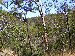
Belair National Park is a protected area in Belair, South Australia, 9 kilometres southeast of Adelaide city centre; it covers an area of 835 hectares. It was proclaimed in 1891 and was the first national park in South Australia, second in Australia and the tenth in the world. The national park lies within the Adelaide Hills and Mitcham council area, and forms part of a chain of protected areas located along the Adelaide Hills Face Zone. The national park is administered by the Department of Environment, Water and Natural Resources.

<span class="mw-page-title-main">Mitcham railway station, Adelaide</span> Railway station in Adelaide, South Australia

Mitcham railway station is located on the Belair line in Adelaide. Situated 8.5 kilometres from Adelaide station, it is in the suburb of Lower Mitcham.

Torrens Park is a mainly residential large inner-southern suburb of Adelaide, incorporating some of the foothills and adjacent to the original "Mitcham Village". It was named after Sir Robert Richard Torrens, the instigator of the Torrens title system of land registration and transfer, who built a large home in the area which he named Torrens Park.

<span class="mw-page-title-main">Colonel Light Gardens, South Australia</span> Suburb of Adelaide, South Australia

Colonel Light Gardens is a suburb located within the Australian City of Mitcham in the greater Adelaide region, approximately 7 km (4 mi) south of the Adelaide city centre. The area is 1.58 km2 (0.61 sq mi). Planned as a garden suburb, it is known for wide, tree-lined streets, presentable postwar bungalow homes, rounded street corners, and much manicured, well maintained open space.

<span class="mw-page-title-main">City of Mitcham</span> Local government area in South Australia

The City of Mitcham is a local government area in the foothills of southern Adelaide, South Australia. Within its bounds is Flinders University, South Australia's third largest, and the notable, affluent suburb of Springfield which contains some of the city's most expensive properties.

Upper Sturt is a suburb in the inner south of Adelaide, South Australia. The suburb is nestled in the lower reaches of the Mount Lofty Ranges with the Western Half located in the City of Mitcham local government area, and the eastern portion located in the Adelaide Hills Council Local Government Area.

Westbourne Park is an inner southern suburb of Adelaide, the State capital of South Australia. The suburb was named after Westbourne, a village in Sussex, England, and was laid out in 1881.

<span class="mw-page-title-main">Belair line</span> Rail line in Adelaide, South Australia

The Belair line is a suburban rail commuter route in the city of Adelaide, South Australia, that runs from the Adelaide station to Belair in the Adelaide Hills via the Adelaide-Wolseley line using diesel 3000/3100 class railcars. Prior to 1995, this part of Adelaide-Wolseley was a two-track broad gauge line. In 1995, Adelaide-Wolseley was converted to standard gauge meaning Adelaide to Belair is now effectively two separate single-track lines running in parallel: the Belair commuter line and the Adelaide-Wolseley standard gauge freight line.

<span class="mw-page-title-main">Bedford Park, South Australia</span> Suburb of Adelaide, South Australia

Bedford Park is a southern suburb of Adelaide in South Australia.

<span class="mw-page-title-main">Blackwood, South Australia</span> Suburb of Adelaide, South Australia

Blackwood is a south-eastern suburb located in the foothills of Adelaide, South Australia. It is part of the local government area of the City of Mitcham.

Clapham, located approximately 8 kilometres (5.0 mi) south of the Adelaide city centre, is a primarily residential suburb situated within the City of Mitcham, incorporating some of the foothills. The suburb is named after Clapham in London, England. Neighbouring suburbs are Colonel Light Gardens, Panorama, Lynton, Torrens Park and Lower Mitcham.

Kingswood is a suburb of the Australian city of Adelaide in the City of Mitcham.

Hawthorn is a suburb of Adelaide, South Australia, in the City of Mitcham. It is bounded to the north by Cross Road, to the south by Grange Road, to the west by Sussex Terrace and to the east by Belair Road. The Belair train line runs through the suburb. To the west is Westbourne Park, and to the east is Kingswood.

Eden Hills is a south eastern suburb located in the foothills of Adelaide, South Australia. It is part of the local government area of the City of Mitcham.

<span class="mw-page-title-main">Brown Hill Creek, South Australia</span> Suburb of Adelaide, South Australia

Brown Hill Creek is a south-eastern suburb of Adelaide in the City of Mitcham in South Australia, named in 1991 after Brown Hill Creek which flows from east to west through the locality. The creek itself was named after Brown Hill which rises immediately south-east of Mitcham village.

Coromandel Valley is a semirural south-eastern suburb of Adelaide, South Australia. It straddles the City of Mitcham and the City of Onkaparinga council areas, with the Sturt River being the boundary between the two council areas.

Lower Mitcham is an inner southern suburb of Adelaide, South Australia in the local government area of Mitcham. To the north, it is bounded by Grange Road, to the east by Belair Road, to the south by Murray Street. To the west, the suburb is bordered by a line running from Murray Street along View Street and continuing north to Grange Road.

<span class="mw-page-title-main">Craigburn Farm, South Australia</span> Suburb of Adelaide, South Australia

Craigburn Farm is a suburb of Adelaide, South Australia, Australia. It is located about 17 km by road south of the city centre.

Glenalta is a suburb located in the south eastern Foothills of the Mount Lofty Ranges of Adelaide, South Australia. It is adjacent to Belair National Park.

Crafers West is a suburb of Adelaide in the Adelaide Hills Council. Located on Peramangk land, it was formally named in 1985 as a separate address from Crafers. Crafers West contains the headwaters of Brown Hill Creek and is dominated by steep terrain and native scrub. It is bounded by Mount Barker Road on the northeast and the Bridgewater railway line on the south. The Eagle Mountain Bike Park is in the north of the suburb. Popular tourist spots include Clealand Conservation Park, Mt Lofty Botanic Gardens, and Belair National Park Holiday Park.

References

  1. Australian Bureau of Statistics (28 June 2022). "Belair (suburb and locality)". Australian Census 2021 QuickStats. Retrieved 28 June 2022.  OOjs UI icon edit-ltr-progressive.svg
  2. 1 2 "Belair". profile.id. Retrieved 7 February 2021.
  3. 1 2 3 "Belair". City of Mitcham. Archived from the original on 16 March 2022. Retrieved 7 February 2021.
  4. 1 2 3 "Sleep's Hill Reserve" (PDF). City of Mitcham. March 2005. Retrieved 7 February 2021.
  5. "The Manning Index of South Australian History - Belair". State Library of South Australia. Archived from the original on 29 July 2008. Retrieved 9 July 2008.
  6. 1 2 3 4 5 6 7 8 Piddock, Susan; Smith, Pamela; Pate, Donald (2004), Hills Face Zone Cultural Heritage Project Archaeological Field Survey of the Belair National Park. Report to the Mitcham Council, Flinders University, retrieved 7 February 2021
  7. "The South Australia Heritage Places database". SA.GOV.AU. Retrieved 7 February 2021.
  8. 1 2 3 4 5 6 "Belair Chronology" (PDF). City of Mitcham. Retrieved 7 February 2021.
  9. "Inebriates' Retreat, Belair". State Library of South Australia. Retrieved 7 February 2021.
  10. George, Karen; George, Gary (15 November 2012). "Kalyra Sanatorium". Find & Connect. Retrieved 7 February 2021.
  11. "Country News". The Register . 25 October 1924. Retrieved 7 February 2021.
  12. "Country Town Happenings". The Register . 26 February 1930. Retrieved 7 February 2021.
  13. "Belair National Park". National Park South Australia. Retrieved 7 February 2021.
  14. "Windy Point". City of Mitcham. Retrieved 7 February 2021.
  15. "Mitcham's Shared Use Trails". City of Mitcham. Retrieved 7 February 2021.
  16. "Climate Data Online" . Retrieved 14 January 2018.
  17. 1 2 3 4 5 6 Australian Bureau of Statistics. "Belair 2021 Census All persons Quickstats" . Retrieved 7 October 2022.
  18. Australian Bureau of Statistics (27 June 2017). "Belair (State Suburb)". 2016 Census QuickStats. Retrieved 7 February 2021. OOjs UI icon edit-ltr-progressive.svg
  19. Australian Bureau of Statistics (31 October 2012). "Belair (State Suburb)". 2011 Census QuickStats. Retrieved 7 February 2021. OOjs UI icon edit-ltr-progressive.svg
  20. "Welcome". Holy Innocents Anglican Church. Retrieved 16 October 2022.
  21. "Belair Uniting Church". The Uniting Church in Australia. Retrieved 16 October 2022.
  22. "Pinera Railway Station". Adelaide Metro. Retrieved 7 October 2022.
  23. "Belair Railway Station". Adelaide Metro. Retrieved 7 October 2022.
  24. "Belair Jean Bonython Kindergarten". preschools.sa.gov.au. Retrieved 16 October 2022.
  25. 1 2 "School History". Belair Primary School. Retrieved 25 October 2022.
  26. "International Baccalaureate". Belair Primary School. Retrieved 25 October 2022.
  27. "Eco School Focus". Belair Primary School. Retrieved 25 October 2022.
  28. "Find a school zone or preschool catchment area". Department for Education . Retrieved 16 October 2022.
  29. "Home". St John's Grammar School. Retrieved 16 October 2022.

34°59′53″S138°37′23″E / 34.9981°S 138.623°E / -34.9981; 138.623