Belconnen, Australian Capital Territory

Last updated

Belconnen
Canberra,  Australian Capital Territory
Belconnen TC aerial west.jpg
Aerial view of Belconnen Town Centre and Lake Ginninderra from the west
Australia Capital Territory location map.svg
Red pog.svg
Belconnen
Coordinates 35°14′13″S149°03′54″E / 35.237°S 149.065°E / -35.237; 149.065 Coordinates: 35°14′13″S149°03′54″E / 35.237°S 149.065°E / -35.237; 149.065
Population8,502 (2021 census) [1]
 • Density1,932/km2 (5,000/sq mi)
Established1983
Postcode(s) 2617
Elevation594 m (1,949 ft)
Area4.4 km2 (1.7 sq mi)
Location
District Belconnen
Territory electorate(s) Ginninderra
Federal division(s) Fenner
Suburbs around Belconnen:
Evatt McKellar Lawson
Florey Belconnen Bruce
Page Macquarie Aranda
Sentinel apartments Sentinel apartments, Belconnen.JPG
Sentinel apartments
Cohen Street Bus Station Cohen Street Bus Station in Belconnen.jpg
Cohen Street Bus Station

Belconnen (postcode: 2617) is the most inner suburb of the larger district of Belconnen in Canberra, Australia. Sharing its name with the larger district which encapsulates it, the suburb is surrounded with well developed infrastructure, and planning which allows it sunset views from the Brindabellas on its western side. The suburb contains important amenities for the District of Belconnen including the Belconnen Town Centre and Lake Ginninderra as well as its own well populated residential areas. It is bounded by Ginninderra Drive, Aikman Drive, Eastern Valley Way, Belconnen Way and Coulter Drive. It has a number of parks such as Margaret Timpson Park, (within the town centre) Eastern Valley Oval (on the lower slope of Emu Ridge) and on the foreshores of Lake Ginninberra, Diddams Close Park and John Knight Memorial Park.

Contents

The name Belconnen has been associated with the district since the days of the early settlers. In the city of Canberra, suburbs are assigned street names that reflect a distinct sub-group of cultural or historical Australian significance. The streets in the suburb of Belconnen are named for Lord Mayors and Mayors. [2]

Features and location

Belconnen Town Centre is the major commercial centre for the Canberra district of Belconnen and is located in the suburb of Belconnen. Belconnen Town Centre includes the region's major shopping centre, Westfield Belconnen (known as Belconnen Mall), [3] large government office buildings including Cameron Offices, Australian Bureau of Statistics and Department of Immigration and Citizenship, and three bus stations.

The service and trades area is located in the suburb's west. In this area can be found car dealers and repairers, petrol stations, hardware stores, restaurants and many other specialty retailers.

Lake Ginninderra College, a secondary college for years 11 and 12, is located on Emu Bank, on the south-eastern shore of Lake Ginninderra.

The Belconnen Arts Centre is on Emu Bank, on the southern shore of Lake Ginninderra.

Residential areas

Belconnen includes residential development areas, "Emu Ridge" in the south-east, "Ginninderra Heights" in the north-west and apartment buildings in Chandler and Beissel Streets.

Emu Ridge

Emu Ridge is bounded by Benjamin Way, College Street, Eastern Valley Way and Belconnen Way; Hennessy Street and Condell Street are the two main thoroughfares, with many cul-de-sacs off these. Emu Ridge consists solely of low to medium-density housing. Emu Ridge is often regarded as a suburb, mainly due to its distinct boundaries and because the name helps differentiate this part of the suburb from other parts of the suburb.

Ginninderra Heights

Ginninderra Heights was the name given to the medium-density residential development centred on Totterdell Street in the north-west of Belconnen.

Demographics

At the 2022 census, the population of Belconnen was 8,502, an increase from 4,437 in 2011 [4] and 2,826 in 2001, [5] including 1.5% Indigenous persons. [1] 45.2% of people were born in Australia. The next most common countries of birth were China (excluding SARs and Taiwan, 11.1%), India (6.2%), Nepal (5.7%) and the Philippines (2.4%). 48.5% of people spoke only English at home. Other languages spoken at home included Mandarin (11.6%), Nepali (5.5%), Cantonese (1.9%), Vietnamese (1.7%) and Korean (1.7%). The most common responses for religion were No Religion (45.5%), Catholic (11.9%) and Hinduism (9.9%). 74.9% of dwellings were units or apartments and 24.7% were semi-detached, row or terrace house or townhouses. [1]

Political representation

For the purposes of Australian federal elections for the House of Representatives, Belconnen is in the Division of Fenner. [6]

For the purposes of Australian Capital Territory elections for the ACT Legislative Assembly, Belconnen is in the Ginninderra electorate. [7]

Geology

Lake Ginninderra adjacent to Belconnen Town Centre Lake Ginninderra wetlands 2.JPG
Lake Ginninderra adjacent to Belconnen Town Centre

Belconnen has the highest density of different kinds of rocks outcropping of any Canberra suburb. It is at the intersection of two faults that form an X shape across Canberra. These are the Deakin Fault and the Winslade Fault. Green grey rhyodacite of the Walker Volcanics is in the south along Belconnen Way. Deakin Volcanics purple rhyodacite is around the north end of Josephson St. Deakin Volcanics green grey and purple rhyodacite goes east from Lathlain Dr to Chandler St. Grey green dacite and quartz andesite Hawkins Volcanics is in a strip from the north west corner heading south east between two branches of the Deakin fault to around Chandler St and Hennessey St. A porphyry of Green-grey Dacitic intrusive containing large white Feldspar crystals is west of Eastern Valley Way and in between the two arms of Lake Ginninderra. Glebe Farm Adamellite intrusion is found to the south and east of Lake Ginninderra. Ordovician Pittman Formation greywacke is in the extreme south east and far north east of the town centre. Calcareous Shale from the Yass Subgroup is to the west of Lake Ginninderra. Dark grey and black laminated shale from the Acton Shale member is found on the west side of the Diddams Close Park in between the two arms of the lake. [8]

Related Research Articles

<span class="mw-page-title-main">Belconnen</span> Place in Australian Capital Territory

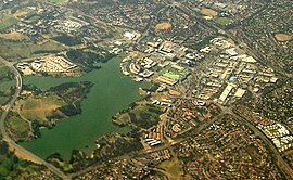
Belconnen is one of the original eighteen districts of the Australian Capital Territory, used in land administration. The district is subdivided into 27 divisions (suburbs), sections and blocks.

Cook is a suburb of the Belconnen district of Canberra, located within the Australian Capital Territory, Australia. At the 2016 census, Cook had a population of 2,965 people.

<span class="mw-page-title-main">Florey, Australian Capital Territory</span> Suburb of Canberra, Australian Capital Territory

Florey is a residential suburb of the Belconnen district of Canberra, located within the Australian Capital Territory, Australia. Florey was gazetted on 5 August 1975 and most houses were constructed in the mid-1980s.

<span class="mw-page-title-main">Macquarie, Australian Capital Territory</span> Suburb of Canberra, Australian Capital Territory

Macquarie is a residential suburb in the Belconnen district of Canberra, located within the Australian Capital Territory, Australia. Macquarie was gazetted as a division on 22 June 1967 in recognition of Major-General Lachlan Macquarie, a former Governor of New South Wales. Streets in Macquarie are named after contemporaries of Governor Macquarie.

<span class="mw-page-title-main">Charnwood, Australian Capital Territory</span> Suburb of Canberra, Australian Capital Territory

Charnwood is a suburb in the Belconnen district of Canberra located within the Australian Capital Territory, Australia.

Melba is a residential suburb in the Belconnen district of Canberra, located within the Australian Capital Territory, Australia. The suburb of Melba is named after Dame Nellie Melba (1861–1931), the first internationally recognised Australian opera soprano. The streets are named after composers, singers and other musically notable Australians or people with strong Australian connections.

<span class="mw-page-title-main">Aranda, Australian Capital Territory</span> Suburb of Canberra, Australian Capital Territory

Aranda is a suburb in the district of Belconnen, in the Australian capital city of Canberra. Located at the western foot of Black Mountain and bounded on two sides by nature park, the suburb is characterised by its bush setting. During the planning and development of the suburb, a large proportion of large native trees – predominantly eucalypts – were left in place.

<span class="mw-page-title-main">Page, Australian Capital Territory</span> Suburb of Canberra, Australian Capital Territory

Page is a residential suburb in the Belconnen district of Canberra, located within the Australian Capital Territory, Australia. The suburb is named in honour of Sir Earle Page, a Prime Minister. Streets in Page are named in honour of Australian scientists. Page was established in 1968.

<span class="mw-page-title-main">Dunlop, Australian Capital Territory</span> Suburb of Canberra, Australian Capital Territory

Dunlop is a suburb of the Belconnen district of Canberra, located within the Australian Capital Territory, Australia. Dunlop is at the far north-west edge of Canberra, near the border with the state of New South Wales. Approximately 11.6 kilometres (7.2 mi) north-west of the city, Dunlop is next to the suburbs of Fraser, Charnwood and Macgregor. At the edge and within Dunlop lies the Canberra Nature Park called Dunlop Grasslands Nature Reserve, West Belconnen Ponds, Jarramlee Pond and Fassifern Pond which are part of the Ginninderra Catchment.

Evatt is a suburb in the Belconnen district of Canberra, located within the Australian Capital Territory, Australia. Evatt lies between the suburbs of McKellar, Belconnen, Florey, Melba and Spence.

Flynn is a suburb in the Belconnen district of Canberra, located within the Australian Capital Territory, Australia.

Higgins is a suburb in the Belconnen district of Canberra, in the Australian Capital Territory, Australia. The suburb is named after politician and judge Henry Bournes Higgins (1851–1929). It was gazetted on 6 June 1968. The streets of Higgins are named after judges.

Holt is a suburb in the Belconnen district of Canberra, located within the Australian Capital Territory, Australia. It was gazetted on 2 July 1970 and was named after Harold Holt, Prime Minister of Australia 1966–67. Streets are named after sportsmen and sportswomen.

<span class="mw-page-title-main">Kaleen</span> Suburb of Canberra, Australian Capital Territory

Kaleen is a suburb in the Belconnen district of Canberra, located within the Australian Capital Territory, Australia. The suburb's name means ‘water’ in the language of the Wiradjuri Aboriginal tribe of the central west region of New South Wales. Kaleen was gazetted as a suburb on 15 January 1974. The streets are named after Australian rivers.

Latham is a residential suburb in the Belconnen district of Canberra, located within the Australian Capital Territory, Australia. The suburb is named for John Latham, Chief Justice of the High Court of Australia from 1935 to 1952. Streets in Latham have the names of Australian judges.

<span class="mw-page-title-main">Lawson, Australian Capital Territory</span> Suburb of Canberra, Australian Capital Territory

Lawson is a suburb in the Belconnen district of Canberra, located within the Australian Capital Territory, Australia. The suburb is surrounded by Baldwin Drive, Gundaroo Drive and Ginninderra Drive. It lies next to the suburbs of McKellar, Giralang, Kaleen, Bruce and Belconnen.

Macgregor is a residential suburb in the Belconnen district of Canberra, located within the Australian Capital Territory, Australia. It was gazetted on 9 September 1971. It lies next to the suburbs of Dunlop, Latham and Holt on the western side of Belconnen, with Florey Drive the boundary to the east, Ginninderra Drive on the north, and Southern Cross Drive on the south.

<span class="mw-page-title-main">Scullin, Australian Capital Territory</span> Suburb of Canberra, Australian Capital Territory

Scullin is a residential suburb in the Belconnen district of Canberra, located within the Australian Capital Territory, Australia. The suburb is named after Prime Minister of Australia James Scullin. It was gazetted on 6 June 1968. In the city of Canberra, suburbs are assigned street names that reflect a distinct sub-group of cultural or historical Australian significance. The streets in the suburb of Scullin are named after aviators. Scullin is located adjacent to the suburbs of Higgins, Florey, Page and Hawker. Southern Cross Early Childhood School and Scullin neighbourhood oval are located within the suburb. It is bordered by Kingsford Smith Drive, Belconnen Way, Southern Cross Drive and Chewings Street. Scullin is approximately 20 minutes walk and 5 minutes by car from the Belconnen Town Centre and 15 minutes walk and 3 minutes by car from the Hawker Shopping Centre. It is approximately 10 to 15 minutes by car from Canberra City and 30 minutes from Canberra Airport.

<span class="mw-page-title-main">Geology of the Australian Capital Territory</span> Overview of the geology of the Australian Capital Territory

The geology of the Australian Capital Territory includes rocks dating from the Ordovician around 480 million years ago, whilst most rocks are from the Silurian. During the Ordovician period the region—along with most of eastern Australia—was part of the ocean floor. The area contains the Pittman Formation consisting largely of Quartz-rich sandstone, siltstone and shale; the Adaminaby Beds and the Acton Shale.

<span class="mw-page-title-main">Emu Ridge, Australian Capital Territory</span> Place in Australian Capital Territory

Emu Ridge is a housing estate in the suburb of Belconnen, located in the district of Belconnen, in Canberra, within the Australian Capital Territory (ACT) of Australia. Emu Ridge is bounded by Benjamin Way, College Street, Eastern Valley Way and Belconnen Way; Hennessy Street and Condell Street are the two main thoroughfares, with many cul-de-sacs off these.

References

  1. 1 2 3 Australian Bureau of Statistics (28 June 2022). "Belconnen". 2021 Census QuickStats. Retrieved 4 September 2022. OOjs UI icon edit-ltr-progressive.svg
  2. "Suburb Name search results". ACT Environment and Sustainable Development. Retrieved 11 January 2013.
  3. Bacon, Erika (7 March 2014). "A weekend in your suburb: 36 hours in Belconnen". The Canberra Times. Archived from the original on 7 March 2014.
  4. Australian Bureau of Statistics (31 October 2012). "Belconnen". 2011 Census QuickStats. Retrieved 4 September 2022. OOjs UI icon edit-ltr-progressive.svg
  5. Australian Bureau of Statistics (9 March 2006). "Belconnen". 2001 Census QuickStats. Retrieved 4 September 2022. OOjs UI icon edit-ltr-progressive.svg
  6. "Profile of the electoral division of Fenner (ACT)". Current federal electoral divisions. Australian Electoral Commission. 8 February 2016. Retrieved 29 May 2016.
  7. "Electorates 2012 election". Electorates. ACT Electoral Commission. 5 July 2012. Retrieved 17 December 2013.
  8. Henderson, G. A. M.; Matveev, G. (1980). Geology of Canberra, Queanbeyan and Environs 1:50000 (Map).