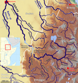
Beles River

Last updated
Map showing the Abbay basin, with the Beles River (Centre) Abbay OSM.png
Map showing the Abbay basin, with the Beles River (Centre)

Beles River (Kusa in Gumuz language) is a river of western Ethiopia. A tributary of the Abay river (better known as the Blue Nile), the Beles rises in Dangur woreda to flow in a south-west direction to its confluence. Its catchment area amounts to about 14,200 square kilometers. [1]

Contents

Course

The source is located 15 km west of Lake Tana at an elevation of 2,100 metres (6,900 ft) above sea level. The mouth of the river Beles in the Blue Nile is located about 40 km upstream of the Grand Ethiopian Renaissance dam that is under construction, and the water of the Beles will be used in the future.

Transferred water from Lake Tana

Since the Tana Beles hydroelectric power plant has been put into operation in 2010, the Beles has received water from Lake Tana via the Tana-Beles interbasin transfer, which is to be used in a series of irrigation projects below the power plant. For this purpose a series of dams were built.

Beles River, after receiving the transferred water from Lake Tana Beles downstream of Tana outlet.jpg
Beles River, after receiving the transferred water from Lake Tana

These large water transfers from Lake Tana to Beles River affect the movement of people, the hydrogeomorphology, and ecology of the river. [2] The Environmental Impact Assessment of the Beles hydropower project is however considered a formality and is unfindable. [3] The social impacts of the Tana-Beles water transfer have been studied and results published in the high-profile Journal of Hydrology : the dangerously high increases in discharge of Beles river have led to the drowning of 250 people between 2010 and 2018. The negative impacts on rural livelihoods are however overshadowed by national development goals (electricity production). The external costs (coping with damage) are borne by local people, who have low bargaining power. [3]

See also

Notes

  1. "Tana & Beles Integrated Water Resources Development: Project Appraisal Document (PAD), Vol.1", World Bank, 2 May 2008 (accessed 5 May 2009)
  2. Nyssen, J. and colleagues (2018). "Persistence and changes in the peripheral Beles basin of Ethiopia". Regional Environmental Change. 18: 2089–2104. doi:10.1007/s10113-018-1346-2. hdl: 10067/1541370151162165141 .
  3. 1 2 Annys, S. and colleagues (2019). "Impacts of the hydropower-controlled Tana-Beles interbasin water transfer on downstream rural livelihoods (northwest Ethiopia)". Journal of Hydrology. 569: 436–448. doi:10.1016/j.jhydrol.2018.12.012. hdl: 1942/28548 .

Coordinates: 10°54′N35°16′E / 10.900°N 35.267°E / 10.900; 35.267

Related Research Articles

Nile Major river in northeastern Africa

The Nile is a major north-flowing river in northeastern Africa. It flows into the Mediterranean Sea. The Nile is the longest river in Africa and has historically been considered the longest river in the world, though this has been contested by research suggesting that the Amazon River is slightly longer. Of the world's major rivers, the Nile is one of the smallest, as measured by annual flow in cubic metres of water. About 6,650 km (4,130 mi) long, its drainage basin covers eleven countries: the Democratic Republic of the Congo, Tanzania, Burundi, Rwanda, Uganda, Kenya, Ethiopia, Eritrea, South Sudan, Republic of the Sudan, and Egypt. In particular, the Nile is the primary water source of Egypt, Sudan and South Sudan. Additionally, the Nile is an important economic river, supporting agriculture and fishing.

Blue Nile Major river flowing across western Ethiopia

The Blue Nile is a river originating at Lake Tana in Ethiopia. It travels for approximately 1,450 km (900 mi) through Ethiopia and Sudan. Along with the White Nile, it is one of the two major tributaries of the Nile and supplies about 80% of the water to the Nile during the rainy season.

Hydroelectricity Electricity generated by hydropower

Hydroelectricity, or hydroelectric power, is electricity produced from hydropower. In 2020 hydropower generated one sixth of the world's electricity, almost 4500 TWh, which was more than all other renewables combined and also more than nuclear power.

Akosombo Dam Dam in Akosombo, Ghana

The Akosombo Dam, also known as the Volta Dam, is a hydroelectric dam on the Volta River in southeastern Ghana in the Akosombo gorge and part of the Volta River Authority. The construction of the dam flooded part of the Volta River Basin, and led to the subsequent creation of Lake Volta. Lake Volta is the largest man-made lake in the world by surface area. It covers 8,502 square kilometres (3,283 sq mi), which is 3.6% of Ghana's land area. With a volume of 148 cubic kilometers, Lake Volta is the world's third largest man-made lake by volume, the largest being Lake Kariba, and contains 185 cubic kilometers of water.

Tana River (Kenya)

The ca. 1000 km long Tana River is the longest river in Kenya, and gives its name to the Tana River County. Its catchment covers ca. 100,000 km² and can be divided into the headwaters and the lower Tana consisting of the section downstream of Kora where the river flows for ca. 700 km through semi-arid plains. Its tributaries include the Thika, Ragati River from Mt.Kenya as well as several smaller rivers that flow only during the rainy season. The river rises in the Aberdare Mountains to the west of Nyeri. Initially it runs east before turning south around the massif of Mount Kenya. A series of hydroelectric dams has been constructed along the river. These include the Masinga Dam, the Kamburu Dam, the Gitaru Dam, the Kindaruma Dam and the Kiambere Dam. en The Masinga Reservoir and the Kiambere Reservoir, created by the Masinga and Kiambere dams respectively, serve a dual purpose: hydro-electric power (HEP) generation and agricultural irrigation. The other three are used exclusively for HEP generation. A 2003 study reported that two-thirds of Kenya's electrical needs were supplied by the series of dams along the Tana River. Many people believe this river has groundwater underneath it, but it doesn't. The electricity is then supplied to the national grid system and distributed countrywide through a series of substations, transformers and cables.

Merowe Dam Dam in Merowe, Sudan

The Merowe Dam, also known as Merowe High Dam, Merowe Multi-Purpose Hydro Project or Hamdab Dam, is a large dam near Merowe Town in northern Sudan, about 350 kilometres (220 mi) north of the capital Khartoum. Its dimensions make it the largest contemporary hydropower project in Africa. It is situated on the river Nile, close to and inundating the 4th Cataract where the river divides into multiple smaller branches with large islands in between. Merowe is a city about 40 kilometres (25 mi) downstream from the construction site at Hamdab. The main purpose for building the dam was the generation of electricity.

Run-of-the-river hydroelectricity Hydroelectric power station

Run-of-river hydroelectricity (ROR) or run-of-the-river hydroelectricity is a type of hydroelectric generation plant whereby little or no water storage is provided. Run-of-the-river power plants may have no water storage at all or a limited amount of storage, in which case the storage reservoir is referred to as pondage. A plant without pondage is subject to seasonal river flows, thus the plant will operate as an intermittent energy source. Conventional hydro uses reservoirs, which regulate water for flood control, dispatchable electrical power, and the provision of fresh water for agriculture.

The Nile Basin Initiative (NBI) is a partnership among the Nile riparian states that “seeks to develop the river in a cooperative manner, share substantial socioeconomic benefits, and promote regional peace and security”. The NBI began with a dialogue among the riparian states that resulted in a shared vision objective “to achieve sustainable socioeconomic development through the equitable utilization of, and benefit from, the common Nile Basin water resources." It was formally launched in February 1999 by the water ministers of nine countries that share the river: Egypt, Sudan, Ethiopia, Uganda, Kenya, Tanzania, Burundi, Rwanda, the Democratic Republic of Congo (DRC), as well as Eritrea as an observer. From its beginning the Nile Basin Initiative has been supported by the World Bank and by other external partners. The World Bank has a mandate to support the work of the NBI, as lead development partner and as administrator of the multi-donor Nile Basin Trust Fund. One of the partners is the "Nile Basin Discourse", which describes itself as "a civil society network of organisations seeking to achieve positive influence over the development of projects and programmes under the Nile Basin Initiative".

Interbasin transfer

Interbasin transfer or transbasin diversion are terms used to describe man-made conveyance schemes which move water from one river basin where it is available, to another basin where water is less available or could be utilized better for human development. The purpose of such water resource engineering schemes can be to alleviate water shortages in the receiving basin, to generate electricity, or both. Rarely, as in the case of the Glory River which diverted water from the Tigris to Euphrates River in modern Iraq, interbasin transfers have been undertaken for political purposes. While ancient water supply examples exist, the first modern developments were undertaken in the 19th century in Australia, India and the United States, feeding large cities such as Denver and Los Angeles. Since the 20th century many more similar projects have followed in other countries, including Israel and China, and contributions to the Green Revolution in India and hydropower development in Canada.

Nyagak Power Station is a 3.5 megawatts (4,700 hp) mini hydroelectric power plant in Uganda.

Energy in Ethiopia is energy and electricity production, consumption, transport, exportation, and importation in Ethiopia.

Gilgel Gibe III Dam Dam in Nationalities, and Peoples Region

The Gilgel Gibe III Dam is a 250 m high roller-compacted concrete dam with an associated hydroelectric power plant on the Omo River in Ethiopia. It is located about 62 km (39 mi) west of Sodo in the Southern Nations, Nationalities, and Peoples' Region. Once fully commissioned, it will be the third largest hydroelectric plant in Africa with a power output of about 1870 Megawatt (MW), thus more than doubling total installed capacity in Ethiopia from its 2007 level of 814 MW. The Gibe III dam is part of the Gibe cascade, a series of dams including the existing Gibe I dam and Gibe II power station as well as the planned Gibe IV and Gibe V dams. The existing dams are owned and operated by the state-owned Ethiopian Electric Power, which is also the client for the Gibe III Dam.

Ethiopia is called the water tower of Africa due to its combination of mountainous areas with a comparatively large share of water resources in Africa. Only a fraction of this potential has been harnessed so far, 1% at the beginning of the 21st century. In order to become the powerhouse of Africa, Ethiopia is actively exploiting its water resources by building dams, reservoirs, irrigation and diversion canals and hydropower stations. The benefits of the dams are not only limited to hydropower. Many dams are multi-purpose dams that are also designed to provide water for irrigation, drinking water and flood control. However, hydropower is expected to be the main benefit of the dams.

The Beles Hydroelectric Power Plant, sometimes referred to as Beles II or Tana Beles, is a run-of-the-river hydroelectric power plant in Ethiopia near Lake Tana. The power plant receives water from the lake through the Tana-Beles interbasin transfer and after utilizing it to produce electricity, the water is then discharged into the Beles River. The plant has an installed capacity of 460 MW and it is the second largest power plant in the country. It is also expected to help provide water for the irrigation of 140,000 ha. It was inaugurated in May 2010 and the last generator was operational in February 2012. Its construction was negatively perceived by downstream Egypt.

Hydropower in the Mekong River Basin

The estimated hydropower potential of the lower Mekong Basin is 30,000 MW, while that of the upper Mekong Basin is 28,930 MW. In the lower Mekong, more than 3,235 MW has been realized via facilities built largely over the past ten years, while projects under construction will represent an additional 3,209 MW. An additional 134 projects are planned for the lower Mekong, which will maximize the river's hydropower generating capacity. The single most significant impact—both now and in the future—on the use of water and its management in the Mekong Region is hydropower.

The Grand Ethiopian Renaissance Dam, formerly known as the Millennium Dam and sometimes referred to as Hidase Dam, is a gravity dam on the Blue Nile River in Ethiopia under construction since 2011. The dam is in the Benishangul-Gumuz Region of Ethiopia, about 45 km (28 mi) east of the border with Sudan.

Energy in Sudan describes energy and electricity production, consumption and imports in Sudan. The chief sources of energy in 2010 were wood and charcoal, hydroelectric power, and oil. Sudan is a net energy exporter. Primary energy use in Sudan was 179 TWh and 4 TWh per million persons in 2008.

This page describes energy and electricity production, consumption and import in Laos.

Julius Nyerere Hydropower Station is a hydroelectric dam under construction across the Rufiji River in eastern Tanzania. Although controversial, the government approved the plans in 2018. The power station is expected to have an installed capacity of 2,115 megawatts (2,836,000 hp) and to produce 5,920GWh of power annually. The project, power station and dam are owned by and will be managed by the government owned Tanzania Electric Supply Company (TANESCO). Construction began in 2019 and is expected to be completed in 2022.

Tana-Beles interbasin water transfer

The Tana-Beles interbasin water transfer takes water from Lake Tana in Ethiopia and delivers it to the Beles River via the Tana Beles hydroelectric power plant. The water downstream is also used for irrigation.