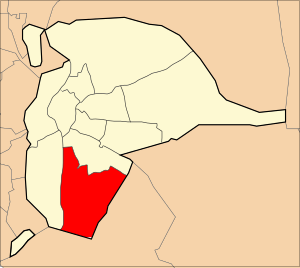
Bellavista-La Palmera is a district of the city of Seville, the regional capital of the Spanish region of Andalusia. It is situated on the eastern bank of the Guadalquivir river, to the south of the city centre (Casco Antiguo).
Bellavista-La Palmera is a district of the city of Seville, the regional capital of the Spanish region of Andalusia. It is situated on the eastern bank of the Guadalquivir river, to the south of the city centre (Casco Antiguo).
The district is bordered by the Distrito Sur to the north. To the west, across the river on the Isla de La Cartuja, it borders the district of Los Remedios. The neighbouring municipality of Dos Hermanas borders the district to the east and south. The Guadaira river flows through the district before joining the Guadalquivir. The only territory in the whole of Seville to the south of the Guadaira is the neighbourhood of Bellavista, which transferred into the district from Dos Hermanas.
The science and technology enterprise Abengoa is based in the district. [1] The professional top-flight football club Real Betis play in the neighbourhood of Heliópolis, the source of their nickname Los Heliopitanos. [2]

Seville is the capital and largest city of the Spanish autonomous community of Andalusia and the province of Seville. It is situated on the lower reaches of the River Guadalquivir, in the southwest of the Iberian Peninsula.

Dos Hermanas is a Spanish city 15 km (9.3 mi) south of Seville in Andalusia, with a population of 131,317 as of 2015.

Utrera is a municipality in south-west Spain. It is in the province of Seville, in the autonomous community of Andalusia. As of 2018 it has a population of 52,617.
Isla de la Cartuja is an island in the Guadalquivir River at Seville, Spain.

Alcalá de Guadaíra is a town located approximately 17 km southeast of Seville, Spain; in recent years the expansion of Seville has meant that Alcalá has become a suburb of that city. Alcalá used to be known as Alcalá de los Panaderos because it provided most of Seville's bread. The town is located on the banks of the Guadaíra River, and watermills built during the Moorish period of Spain can still be found in the area.

Macarena is one of the eleven districts into which the city of Seville, capital of the autonomous community of Andalucía, Spain, is divided for administrative purposes. It is located in the north of the city, bordered to the south by the Casco Antiguo and San Pablo-Santa Justa suburbs, to the east and north by Norte and to the west by Triana. It covers the area between the Guadalquivir River and the Carmona Highway and from the SE-30 ring-road in the north to the Ronda del Casco Antiguo. It contains smaller neighbourhoods such as León XIII, Miraflores, and the Polígono Norte as well as the Miraflores park along the SE-30. The district contains the Andalucian Parliament, the Torre de los Perdigones in the park of the same name, and the Hospital Universitario Virgen Macarena

Triana is a neighbourhood and administrative district on the west bank of the Guadalquivir River in the city of Seville, Spain. Like other neighborhoods that were historically separated from the main city, it was known as an arrabal. Triana is located on a peninsula between two branches of the Guadalquivir, narrowly linked to the mainland in the north. Two other districts are also usually included in this area, Los Remedios to the south and La Cartuja to the north.

Los Remedios is a district of Seville, the regional capital of Andalusia, Spain. It is located on the Isla de La Cartuja, south of the district of Triana, between two forks of the Guadalquivir river. It is linked by bridge to the city centre and the districts of Distrito Sur and Bellavista-La Palmera. From the western side of the island, it is linked by road bridge to the city of San Juan de Aznalfarache and shares a boundary in the Guadalquivir with the city of Gelves. The southern tip of La Cartuja is opposite the municipality of Dos Hermanas.
Bellavista is a neighbourhood in the Bellavista-La Palmera district in the south of the city of Seville, Andalusia, Spain. It lies on the east bank of the Guadaira river, a tributary of the Guadalquivir. Bellavista once belonged to the town of Dos Hermanas, but were sold to the city of Seville. Bellavista, which means Beautiful View in Spanish, is thus the southernmost neighbourhood in Seville, and quite separated from the rest of the city.

The Alameda de Hércules , or simply La Alameda, is a garden square or mall in Seville, southern Spain. Built in 1574, it was originally a promenaded public garden, named after the eight rows of white poplar trees that fill its central part. Located in the northern half of the city's casco antiguo, between the Guadalquivir River and the Macarena neighbourhood, it was the oldest public garden in Spain and Europe.

El Arenal is a neighbourhood in the historical centre of Seville, the Casco Antiguo. It lies on the east bank of the Guadalquivir river to the west of the old Jewish Quarter, Santa Cruz, and south of the neighbourhoods of Museo and Alfalfa. Its name comes from the sandy nature that this east bank of the river once used to have. El Arenal has a history characterised by its former position as the port of Seville, until river silting forced the city to relocate the port to the southern edge of the city in the 17th century.

The Casco Antiguo is the city centre district of Seville, the capital of the Spanish region of Andalusia. The Casco Antiguo comprises Seville's old town, which lies on the east bank of the Guadalquivir river. It borders the districts of Macarena to the north, Nervión and San Pablo-Santa Justa to the east, and the Distrito Sur to the south. Bridges across the Guadalquivir link the Casco Antiguo to Los Remedios, Triana and La Cartuja.
The Guadaíra is a river that runs through the province of Seville, in Andalusia, southern Spain. Its name contains the same guad root as the much larger Rio Guadalquivir, coming from the Arabic word wadi, meaning "river valley".

Brenes is a city located in the province of Seville, Spain. According to the 2014 census (INE), the city has a population of 12,737 inhabitants. It covers an area of 22 km2 with a density of 598,46 inhabitants/km2. Their geo-coordinates are: 37º 33' N, 5º 52' O and it is 18 m above sea level. The provincial capital, Seville, is 22 km away.

Gelves is a city located in the province of Seville, in Andalusia, Spain. According to the 2006 census (INE), the city has a population of 8,325 inhabitants. It lies on the west bank of the Guadalquivir river.
San Juan de Aznalfarache is a city located in the province of Seville, Spain. According to the 2006 census (INE), the city has a population of 20,121 inhabitants.

Manuel García y Rodríguez was a Spanish costumbrista and landscape painter, who also painted Orientalist scenes.

Los Palacios is a Spanish geographical indication for Vino de la Tierra wines located in the autonomous region of Andalusia. Vino de la Tierra is one step below the mainstream Denominación de Origen indication on the Spanish wine quality ladder.
Seville, the capital of the region of Andalusia in Spain, has 11 districts, further divided into 108 neighbourhoods.

The Castle of San Jorge was a medieval fortress built on the west bank of the Guadalquivir river in the Spanish city of Seville (Spain). It was also used as headquarters and prison for the Spanish Inquisition. It was demolished in the 19th century and made into a food market. A museum in the underground ruins focuses on the history of the castle, the Spanish Inquisition and of religious repression. Next to the food market in the Barrio de Triana, the Alley of the Inquisition, which was part of the fortifications, now connects Castilla Street with the Nuestra Señora de la O Walk.
{{cite web}}: CS1 maint: archived copy as title (link)