Belledonne

Last updated

Belledonne
Moonrise on Grand Pic de Belledonne.jpg
The moon rises behind Belledonne's Grand Pic, to the left of Grande Lance de Domène
Highest point
PeakGrand Pic de Belledonne
Elevation 2,977 m (9,767 ft)
Coordinates 45°03′N5°48′E / 45.050°N 5.800°E / 45.050; 5.800
Dimensions
Length60 km (37 mi)
Width10 km (6.2 mi)
Geography
CountryFrance
Parent range Dauphiné Alps


Belledonne (French: La chaîne de Belledonne, French pronunciation: [ʃɛnbɛldɔn] ) is a mountain range (French: massif) in the Dauphiné Alps (part of the French Alps) in southeast France. The southern end of the range forms the eastern wall of the mountains that surround the city of Grenoble.

Contents

The range is noted for the spectacular scenery it provides the inhabitants of Grenoble, numerous ski areas, interesting geology, and a diverse range of alpine land types and uses.

Geography

The Belledonne range is approximately 60 km (37 mi) long by between 10 km (6.2 mi) wide and runs from roughly 45°03′N5°48′E / 45.050°N 5.800°E / 45.050; 5.800 , 16 km (9.9 mi) south-south-east of the city of Grenoble, in a north-easterly direction (actually 35 degrees) for 65 km (40 mi) to roughly 45°33′N6°17′E / 45.550°N 6.283°E / 45.550; 6.283 , near the town of Aiguebelle. The highest point is the Grand Pic de Belledonne, 2,977 m (9,767 ft).

The range is delineated by several valleys which lie at relatively low altitude, including the Grésivaudan Valley (which carries the Isère) on the west, the river Arc to the north and the Romanche to the south. The range counts dozens of peaks over 2,500 m (8,200 ft), more than 10 glaciers, and many alpine lakes, the highest of which is over 2,400 m (7,900 ft) above sea level.

Geologically, Belledonne is a concatenation of ranges which are not physically separated; from north to south, these are: the Grand Arc, the Lauzière, the Sept-Laux, Belledonne proper, and the Taillefer. [1]

Belledonne is a crystalline range. It initiated as a Paleozoic peneplain which was covered by Mesozoic sediments, then raised and tilted during the Tertiary uplift of the Alps and subjected to glacial erosion during the Quaternary. As a result of its geologic history, Belledonne alternates jagged peaks with gentle slopes. [2]

Belledonne overlooks the fairly flat Isère Valley (French: Grésivaudan) which lies only 220 m (720 ft) above sea level near Grenoble. Hence, all alpine vegetation zones are represented:

Panoramic view of Belledonne and of its "balcony". South Belledonne Panorama.jpg
Panoramic view of Belledonne and of its "balcony".

A significant feature is the Belledonne Balcony (French: Le Balcon de Belledonne), a terrace or plateau some 30 km long on the western side of the range that provides a relatively level area intersected by narrow ravines eroded by rivers taking runoff from the snow levels higher up. The Balcony has supported diverse livestock-raising and other agricultural activity for a considerable period of time, and its Southern part is now effectively an upscale suburb of Grenoble.

Main summits

Grand Pic de Belledonne, seen from Biviers. Grand Pic de Belledonne.jpg
Grand Pic de Belledonne, seen from Biviers.
Grande Lance de Domene, seen from Biviers. Grande Lance de Domene.jpg
Grande Lance de Domène, seen from Biviers.
NameElevation
Grand Pic de Belledonne (Le)2,977 m (9,767 ft)
Croix de Belledonne (La)2,929 m (9,610 ft)
Rocher Blanc (Le)2,927 m (9,603 ft)
Aiguilles de l'Argentière (Les)2,915 m (9,564 ft)
Rocher Badon (Le)2,912 m (9,554 ft)
Pyramide (La)2,912 m (9,554 ft)
Puy Gris (Le)2,908 m (9,541 ft)
Bec d'Arguille (Le)2,891 m (9,485 ft)
Aiguille d'Olle (L')2,885 m (9,465 ft)
Rocher d'Arguille (Le)2,885 m (9,465 ft)
Pointe de Comberousse (La)2,866 m (9,403 ft)
Grande Lance d'Allemond (La)2,842 m (9,324 ft)
Charmet de l'Aiguille (Le)2,826 m (9,272 ft)
Pointe de la Porte d'Eglise (La)2,812 m (9,226 ft)
Pic du Frêne (Le)2,807 m (9,209 ft)
Pic du Grand Doménon (Le)2,802 m (9,193 ft)
Grand Morétan (Le)2,800 m (9,200 ft)
Grande Lance de Domène (La)2,790 m (9,150 ft)
Grand Charnier d'Allemont (Le)2,777 m (9,111 ft)
Pic Couttet (Le)2,764 m (9,068 ft)
Grand Crozet (Le)2,762 m (9,062 ft)
Pic de la Grande Valloire (Le)2,758 m (9,049 ft)
Selle du Puy Gris (La)2,758 m (9,049 ft)
Rocher de l'Homme (Le)2,755 m (9,039 ft)
Roche Rousse2,753 m (9,032 ft)
Pic Lamartine (Le)2,752 m (9,029 ft)
Grande Lauzière (La)2,741 m (8,993 ft)

Main glaciers

Glacier de Freydane, below the 3 peaks of Belledonne, July 2007. Glacier freydane.jpg
Glacier de Freydane, below the 3 peaks of Belledonne, July 2007.

The most spectacular glacier in Belledonne is the French: Glacier de Freydane, which is noted for its crevasses.

Main passes

No road cuts across Belledonne. The Pas de la Coche pass, between Belledonne proper and the 7 Laux range, is the only natural break point in the range, and is the only point below 2,000 m (6,600 ft) on the Belledonne ridge (the main water divide between the Isère and the Romanche). Most other passes are not much lower in elevation than their neighboring peaks. At the turn of the 20th century, Joseph Paganon, a minister in several French governments, pushed for linking Laval to the Rivier-d'Allemond by road through the Pas de la Coche. That roadwork started but eventually stopped after Paganon's death at an elevation of 1,336 m (4,383 ft) on the Gresivaudan side, while work never started on the steeper other side (Eau d'Olle). [3] Before the automobile era, locals frequently used this pass to go from Gresivaudan to the Eau d'Olle valley, or to continue to the Maurienne valley via the Glandon pass. Hannibal may have passed the Pas de la Coche when he crossed the Alps with his army. [4]

NameElevation
Pra (Col de la )2,171 m (7,123 ft)
Belledonne (Col de)2,785 m (9,137 ft)
Freydanne (Col de)2,645 m (8,678 ft)
Mine de Fer (Col de la)2,400 m (7,900 ft)
Roche Fendue (Brèche de)2,482 m (8,143 ft)
Coche (Pas de la)1,989 m (6,526 ft)
Sept Laux (Col des)2,184 m (7,165 ft)
Croix (Col de la)2,529 m (8,297 ft)
Tepey (Col du)2,716 m (8,911 ft)
Valloire (Col de la)2,751 m (9,026 ft)
Merlet (Col du)2,286 m (7,500 ft)
Bourbière (Col de la)2,352 m (7,717 ft)
Frèche (Col de la)2,183 m (7,162 ft)
Perrière (Col de la)2,003 m (6,572 ft)
Perche (Col de la)1,984 m (6,509 ft)
Roche Noire (Col de)2,629 m (8,625 ft)
Balmette (Col de la)2,667 m (8,750 ft)

Main lakes

Lake Achard in October 2005. Lac Achard 2.jpg
Lake Achard in October 2005.
Lake Achard in October 2003. Le lac Achard en Octobre.jpg
Lake Achard in October 2003.
Lake Belledonne in September 2007. Belledone Lake.jpg
Lake Belledonne in September 2007.
Lake Noir (2268m) and Blanc (2124m) below Rocher d'Arguille (2885m). Lac noir and lac blanc in grande Valloire valley.JPG
Lake Noir (2268m) and Blanc (2124m) below Rocher d'Arguille (2885m).
Lake Crozet in 2003. Lac du Crozet.jpg
Lake Crozet in 2003.

Belledonne and its lakes have played a major role in industrializing hydroelectricity production as early as 1869 thanks to pioneer Aristide Bergès and his paper mills which tapped water from lake Crozet. [5]

NameElevationGroup
Achard (Lac)1,917 m (6,289 ft)
Robert (Lac)1,998 m (6,555 ft)
Longet (Lac)2,027 m (6,650 ft)
Merlat (Lac)2,044 m (6,706 ft)
Crozet (Lac du)1,974 m (6,476 ft)
Petit Doménon (Lac du)2,380 m (7,810 ft)
Grand Doménon (Lac du)2,385 m (7,825 ft)
Sitre (Lac de la)1,952 m (6,404 ft)
Belledonne (Lac de)2,163 m (7,096 ft)
Blanc (Lac)2,161 m (7,090 ft)
Crop (Lac de)1,906 m (6,253 ft)
Agnelin (Lac de l')2,327 m (7,635 ft)
Jeplan (Lac)2,144 m (7,034 ft)
Sagne (Lac de la)2,065 m (6,775 ft)
Croix (Lac de la)2,415 m (7,923 ft)
Folle (Lac de la)2,142 m (7,028 ft)
Blanc (Lac)2,124 m (6,969 ft)
Noir (Lac)2,268 m (7,441 ft)
Balmettes (Lac des)2,196 m (7,205 ft)
Corne (Lac de la)2,083 m (6,834 ft)7 Laux
Cos (Lac du)2,182 m (7,159 ft)7 Laux
Blanc (Lac)2,248 m (7,375 ft)7 Laux
Cottepens (Lac)2,128 m (6,982 ft)7 Laux
Carré (Lac)2,128 m (6,982 ft)7 Laux
Motte (Lac de la)2,128 m (6,982 ft)7 Laux
Noir (Lac)2,091 m (6,860 ft)7 Laux

Ski resorts

There are 4 main ski resorts in Belledonne, [6] from South to North:

Origin of the name

The origin of the name is not clear. The phrase belle donne means beautiful women in Italian. It does not appear to mean that in Arpitan, and since Arpitan is the ancient regional language, would have been a more likely source of ancient names than Italian. Nevertheless, from one angle the highest peak, the Grand Pic du Belledonne allegedly looks like a woman holding a baby. Other suggested derivations are from the Celtic donne meaning valley, hence beautiful valleys, or indo-European bal, meaning elevated rock, which evolved into bel, then belle. It is difficult without evidence to determine the validity of these derivations.

Fauna

The mountains are home to marmots, chamois, ibex mountain goats and grouse. Reportedly, wolves have returned since 1998, coming from Italy and the press regularly echoes complaints from shepherds about wolves attacking their sheep. [7]

The ibex had completely disappeared from Belledonne. Early 1983, 13 females and 7 males were brought in from Switzerland and by spring 2002, their population had risen to 900 heads. [8]

Related Research Articles

<span class="mw-page-title-main">Isère</span> Department in Auvergne-Rhône-Alpes, France

Isère is a landlocked department in the southeastern French region of Auvergne-Rhône-Alpes. Named after the river Isère, it had a population of 1,271,166 in 2019. Its prefecture is Grenoble. It borders Rhône to the northwest, Ain to the north, Savoie to the east, Hautes-Alpes to the south, Drôme and Ardèche to the southwest and Loire to the west.

<span class="mw-page-title-main">Chartreuse Mountains</span> Mountain range in southeastern France

The Chartreuse Mountains are a mountain range in southeastern France, stretching from the city of Grenoble in the south to the Lac du Bourget in the north. They are part of the French Prealps, which continue as the Bauges to the north and the Vercors to the south.

<span class="mw-page-title-main">Vercors Massif</span> Mountain range in southeastern France

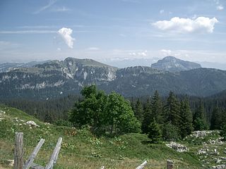
The Vercors Massif is a range in France consisting of rugged plateaus and mountains straddling the départements of Isère and Drôme in the French Prealps. It lies west of the Dauphiné Alps, from which it is separated by the rivers Drac and Isère. The cliffs at the massif's eastern limit face the city of Grenoble.

<span class="mw-page-title-main">Écrins National Park</span> French national park in Isère and Hautes-Alpes

Écrins National Park is a French national park located in the southeastern part of France in the Dauphiné Alps south of Grenoble and north of Gap, shared between the departments of Isère and Hautes-Alpes. The park is one of eight regions in France designated as French national parks.

<span class="mw-page-title-main">Isère (river)</span> River in Auvergne-Rhône-Alpes, France

The Isère is a river in the Auvergne-Rhône-Alpes region of southeastern France. Its source, a glacier known as the Sources de l'Isère, lies in the Vanoise National Park in the Graian Alps of Savoie, near the ski resort in Val-d'Isère on the border with Italy. An important left-bank tributary of the Rhône, the Isère merges with it a few kilometers north of Valence.

<span class="mw-page-title-main">Romanche</span> River in southeastern France

The Romanche is a 78.3-kilometre (48.7 mi) long mountain river in southeastern France. It is a right tributary of the Drac, which is itself a tributary of the Isère. Its drainage basin is 1,221 km2 (471 sq mi). Its source is in the northern part of the Massif des Écrins, Dauphiné Alps. It flows into the Drac in Champ-sur-Drac, south of Grenoble. The road from Grenoble to Briançon over the Col du Lautaret runs through the Romanche valley. There are several mountain and ski resorts in the valley, including Alpe d'Huez, La Grave and Les Deux Alpes.

<span class="mw-page-title-main">Drac (river)</span> River in southeastern France

The Drac is a 130-kilometre (81 mi) long river in southeastern France. It is a left tributary of the river Isère. It is formed at the confluence of the Drac Noir and the Drac Blanc, which both rise in the southern part of the Massif des Écrins, high in the French Alps. It flows through several reservoirs on its course, including the Lac de Monteynard-Avignonet. It flows into the Isère at Grenoble. Its major tributary is the Romanche.

The following is a list of the 29 cantons of the Isère department, in France, following the French canton reorganisation which came into effect in March 2015:

<span class="mw-page-title-main">Matheysine</span>

Matheysine is a French Natural region located in the Alps at the south of the Isère département. Its relief is a plateau surrounded by mountains. Matheysine is also called Plateau Matheysin.

<span class="mw-page-title-main">Biviers</span> Commune in Auvergne-Rhône-Alpes, France

Biviers is a commune in the Isère département in southeastern France.

<span class="mw-page-title-main">Livet-et-Gavet</span> Commune in Auvergne-Rhône-Alpes, France

Livet-et-Gavet is a commune in the Isère department in southeastern France.

<span class="mw-page-title-main">Grésivaudan</span> Valley in France

The Grésivaudan is a valley of the French Alps, situated mostly in the Isère. Etymologically, Graisivaudan comes from roots meaning "Grenoble" (Gratianopolis) and "valley". It comprises the alluvial plain of the river Isère from Grenoble to the confluence of the Arc; or, more recently, the entire valley of the Isère from Tullins to Albertville. The stretch from Tullins to Grenoble is now the Bas-Grésivaudan and that between Grenoble and Albertville is the Haut-Grésivaudan.

<span class="mw-page-title-main">Oisans</span> Valley in the French Alps

L'Oisans is a region in the French Alps, located in the départements of l'Isère and Hautes-Alpes, and corresponding to the drainage basin of the River Romanche and its tributaries. Between Livet-et-Gavet and Le Bourg-d'Oisans, the Romanche forms a deep gorge.

<span class="mw-page-title-main">Alpe du Grand Serre</span>

Alpe du Grand Serre is a ski resort located in the French Dauphine Alps in Isère département, upon the commune of La Morte, sitting at 1368m. The village itself is located at the summit of a mountain pass at the gates of the Oisans valley, between the Romanche valley and the Roizonne valley. Neighbouring mountains are the Taillefer (2857m) and the Grand Serre summit (2141m). It remains a small mountain village with traditional alpine buildings and atmosphere. Thus, it is mostly visited by local people and families from the Grenoble urban area.

<span class="mw-page-title-main">Les Sept Laux</span> Group of winter sports resorts located in the Alps

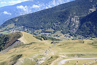
Les Sept Laux is a group of three winter sports resorts of the Alps located in the Belledonne (Isère) about 35 km (22 mi) from Grenoble and 50 km (31 mi) from Chambery in the communes of Theys, Les Adrets and Le Haut-Bréda.

<span class="mw-page-title-main">Henry Duhamel</span>

Henry or Henri Duhamel was a French mountaineer, author and skiing pioneer. He introduced the practice of skiing to his circle of friends at Grenoble, leading to the creation of the first ski club in France.

<span class="mw-page-title-main">Grand Pic de Belledonne</span>

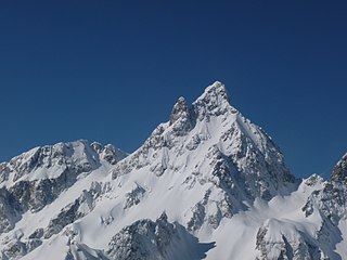
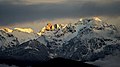
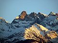
The Grand Pic de Belledonne is the highest mountain in the Belledonne massif in the Dauphiné Alps at 2,977 metres (9,767 ft).

<span class="mw-page-title-main">Croix de Belledonne</span>

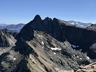
Croix de Belledonne, at 2,926 metres (9,600 ft), is one of the highest points in the Belledonne range in the French Alps, close to the highest summit in the range, Grand Pic de Belledonne at 2,977 metres (9,767 ft). The name derives from the cross erected on the summit.

The Isère-Drac-Romanche Departmental Association is a public administrative establishment in France formed by the Conseil d'État in 1936. Its purpose is to maintain the system of flood-risk protection in the plains of the Isère, Drac, and Romanche rivers by preserving the integrity of embankments and their associated works. The organization performs all research and labor necessary for their preservation and keeps the system under constant surveillance in order to guarantee its efficiency in protecting the land and property at stake behind the embankments.

<span class="mw-page-title-main">Maquis de l'Oisans</span> French resistance group

During the Second World War, the Oisans maquis was an important center for the French Resistance, in the Oisans region between the Belledonne range and Grenoble to the north, the Grandes Rousses massif of the Alps and the Croix de Fer pass to the east, the Drac valley to the west and the Barre des Écrins and the Provencal Alps to the south.

References

The Alps Geology site [1] is an excellent source for geological information on the Belledonne Range and on all of the French Alps.

  1. 1 2 "Chaîne de Belledonne (au sens large) Structure hercynienne et constitution du socle". Géologie et paysages dans les Alpes françaises (in French). Maurice Gidon, professeur de géologie à l'Université scientifique et médicale de Grenoble. Archived from the original on 10 September 2006. Retrieved 7 August 2006.
  2. 1 2 "Isère Environnement Belledonne". Archived from the original on 15 October 2005. Retrieved 24 January 2001.
  3. Pascal Sombardier (2002). Randonnées au cœur des Alpes. Glénat. ISBN   978-2-7234-3997-8.
  4. Geoffroy de Galbert (2006). Hannibal en Gaule. Editions de Belledonne. ISBN   2-911148-65-7.
  5. "Musée de la Houille Blanche" (in French). Archived from the original on 21 February 2009. Retrieved 12 January 2009.
  6. "Stations de ski Isère Belledonne" (in French). Archived from the original on 16 February 2009. Retrieved 2 February 2009.
  7. Lichfield, John (25 July 2002). "Shepherds despair as wolf packs drive sheep to suicide". The Independent. London. Archived from the original on 2 November 2012. Retrieved 24 January 2009.
  8. "Population de Bouquetins du Massif de Belledonne" (in French). 25 June 2007. Archived from the original on 7 January 2009. Retrieved 24 January 2009.