
The Swan River is a major river in the southwest of Western Australia. The river runs through the metropolitan area of Perth, Western Australia's capital and largest city.
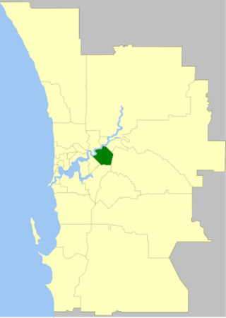
The City of Belmont is a local government area in the inner eastern suburbs of the Western Australian capital city of Perth, located about 8 kilometres (5 mi) east of Perth's central business district on the south bank of the Swan River. The City covers an area of 39.8 square kilometres (15.4 sq mi), maintains 225 km of roads and had a population of almost 40,000 as at the 2016 Census.]

Great Eastern Highway is a 590-kilometre-long (370 mi) road that links the Western Australian capital of Perth with the city of Kalgoorlie. A key route for road vehicles accessing the eastern Wheatbelt and the Goldfields, it is the western portion of the main road link between Perth and the eastern states of Australia. The highway forms the majority of National Highway 94, although the alignment through the Perth suburbs of Guildford and Midland, and the eastern section between Coolgardie and Kalgoorlie are not included. Various segments form parts of other road routes, including National Route 1, Alternative National Route 94, and State Route 51.
The Midland line is a suburban rail service on the Transperth network in Perth, Western Australia. It runs on the Eastern Railway through Perth's eastern suburbs and connects Midland with Perth. Travelling from Midland, the trains terminate at Fremantle on the Fremantle line.
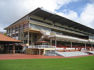
Ascot Racecourse is the major racecourse in Perth, Western Australia, situated approximately 8 kilometres (5.0 mi) east of the Perth central business district, with the headquarters of the Perth Racing positioned directly opposite.

Mount Lawley railway station is 3.2 kilometres (2.0 mi) from Perth railway station, in Western Australia, on the Midland Line and Airport line on the Transperth commuter rail network.

Maylands railway station is a suburban rail station in Maylands, a suburb of Perth, Western Australia. It is on the Midland line and Airport line, between Mount Lawley station and Meltham station. It is 4.5 kilometres (2.8 mi), or eight minutes by train, from Perth station. Services on each line run every 12 minutes during peak and every 15 minutes between peak for a combined frequency of a train every 6 minutes during peak and every 7.5 minutes outside peak.

Bayswater railway station is a suburban rail station in Bayswater, a suburb of Perth, Western Australia. It is the junction station for Transperth's Midland and Airport lines, and the Morley–Ellenbrook line when it opens in late 2024.

Meltham railway station is a railway station in Bayswater, a suburb of Perth, Western Australia. It is on the Midland line and Airport line, between Maylands and Bayswater. It is 5.5 kilometres, or 10 minutes by train, from Perth railway station Services run every 6 minutes during peak and every 7.5 minutes between peak.

Burswood is an inner southeastern suburb of Perth, Western Australia, located immediately across the Swan River from Perth's central business district (CBD). Its local government area is the Town of Victoria Park. Burswood is the location of the State Tennis Centre, Perth Stadium, Belmont Park Racecourse, and the Crown Perth casino and hotel complex.
Embleton is a suburb of Perth, the capital city of Western Australia, located 7 kilometres (4.3 mi) north-east of the central business district, between the suburbs of Morley and Bayswater. Its local government area is the City of Bayswater.

The Causeway is an arterial traffic crossing in Perth, Western Australia, linking the inner-city suburbs of East Perth and Victoria Park. It is carried over the Swan River at the eastern end of Perth Water by two bridges on either side of Heirisson Island. The current Causeway is the third structure to have been built across the river at this point.
Tonkin Highway is an 81-kilometre-long (50 mi) north–south highway and partial freeway in Perth, Western Australia, linking Perth Airport and Kewdale with the city's north-eastern and south-eastern suburbs. As of April 2020, the northern terminus is at the interchange with Brand Highway and Great Northern Highway in Muchea, and the southern terminus is at Thomas Road in Oakford. It forms the entire length of State Route 4, and connects to several major roads. Besides Brand Highway and Great Northern Highway, it also connects to Reid Highway, Great Eastern Highway, Leach Highway, Roe Highway, and Albany Highway.

The South Western Railway, also known as the South West Main Line, is the main railway route between Perth and Bunbury in Western Australia.

Bayswater is a suburb 6 km (4 mi) north-east of the central business district (CBD) of Perth, the capital of Western Australia. It is just north of the Swan River, within the City of Bayswater local government area. It is predominantly a low-density residential suburb consisting of single-family detached homes. However, there are several clusters of commercial buildings, most notably in the suburb's town centre, around the intersection of Whatley Crescent and King William Street and a light industrial area in the suburb's east.

Belmont Park Racecourse is one of the two major horse racing venues within the Perth, Western Australia metropolitan area, the other being Ascot Racecourse, and is located just outside of the central business district on the Burswood Peninsula surrounded by the Swan River. The track has a circumference of 1,699 metres (5,574 ft) with a 333-metre (1,093 ft) straight. Belmont is Perth's winter racecourse, with fully enclosed facilities for spectators.
Guildford Road is a major road in Perth, Western Australia, linking the inner-city suburb of Mount Lawley with Guildford in the north-east. The ten-kilometre-long (6.2 mi) road runs mostly parallel to the Swan River, on its northern side, and is part of State Route 51, which runs between Perth's CBD and Midvale. Guildford Road is maintained and controlled by Main Roads Western Australia, which uses the internal designation "H026 Guildford Road" for Guildford Road, as well as Bridge Street and James Street in Guildford. In the 1930s, the name Great Eastern Highway was coined to describe the road, but was actually used for the road on the other side of the Swan River.

Garratt Road Bridge consists of two adjacent bridges over the Swan River, linking the suburbs of Bayswater and Ascot in Perth, Western Australia. The upstream bridge was built in 1935, while the matching downstream bridge was built in 1972. The site was significant prior to the construction of Garratt Road Bridge – it featured in Aboriginal mythology, and was in the near vicinity of 1880s bridges for pedestrians and trains. From that time there were various proposal to provide a vehicular crossing between Bayswater and Bassendean. Interest peaked in 1928, but plans were delayed due to the Great Depression. The first bridge, designed by Main Roads Chief Engineer Ernest Godfrey, was constructed in 1934–35. It allowed two lanes of traffic to cross the Swan River, alongside pedestrians on an adjacent footbridge.

The Bayswater Subway was a road under rail subway in Perth, Western Australia. It was located immediately west of Bayswater railway station, and carried King William Street / Coode Street beneath the Midland line. The subway was demolished in April 2023 as part of Metronet's rebuild of Bayswater station.
