
Dungannon and South Tyrone Borough Council was a local council in Northern Ireland from 1973 until 2015. It was originally named Dungannon District Council, gaining borough status and adding "South Tyrone" to its name on 25 November 1999, after petitioning the Secretary of State for the Environment. In May 2015, under local government reorganisation in Northern Ireland it merged with Cookstown District Council and Magherafelt District Council to become Mid-Ulster District Council.

Beaghmore is a complex of early Bronze Age megalithic features, stone circles and cairns, 8.5 miles north west of Cookstown, County Tyrone in Northern Ireland, on the south-east edge of the Sperrin Mountains.
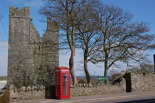
Benburb ) is a village and townland in County Tyrone, Northern Ireland. It lies 7.5 miles from Armagh and 8 miles from Dungannon. The River Blackwater runs alongside the village as does the Ulster Canal.

Olderfleet Castle is a four-storey towerhouse, the remains of which stand on Curran Point to the south of Larne Harbour in Larne, County Antrim, Northern Ireland. The place name of Olderfleet may be a corruption of Ulfrecksfiord, the Viking name for Larne Lough.

Tullyhogue Fort, also spelt Tullaghoge or Tullahoge, is a large mound on the outskirts of Tullyhogue village near Cookstown, County Tyrone, Northern Ireland. It has a depressed centre and is surrounded by trees. It is an ancient ceremonial site where the Chiefs of the Clan O'Neill of Tyrone were inaugurated.

Harry Avery's Castle is situated half a mile south-west of Newtownstewart, in County Tyrone, Northern Ireland. It is a rare example of a stone castle built by a Gaelic Irish chief, although its origins and history are uncertain. It is associated with and named after Henry Aimhréidh O'Neill, whose name was anglicised as Harry Avery.

Stewart Castle is situated in Newtownstewart, County Tyrone, Northern Ireland. It was built in 1619 by Sir Robert Newcomen in an "English manor house" style. It was damaged during the Irish Rebellion of 1641 by Sir Phelim O' Neill and in 1689 on King James' return from the Siege of Derry. King James ordered the Stewart Castle, and the town, to be burnt down. In the main street a piece of the castle wall still stands.

Moyry Castle is situated in County Armagh, Northern Ireland. It was built during the latter stages of the Nine Years' War in June 1601 by Lord Mountjoy to help secure Moyry Pass and the Gap of the North. It is set in the corner of a small bawn and is a small rectangular tower three storeys high.

Monea Castle is a castle in Monea, County Fermanagh, Northern Ireland. It is a State Care Historic Monument sited in the townland of Castletown Monea, in Fermanagh District Council area, at grid ref: H1647 4937.

Tully Castle is a castle situated in County Fermanagh, Northern Ireland, near the village of Blaney, on Blaney Bay on the southern shore of Lower Lough Erne. The Blaney area takes its name from Sir Edward Blaney, who was among the English advance party sent to Fermanagh to organise the Plantation.
Jordan's Castle is a castle situated in Ardglass, County Down, Northern Ireland. The tower house known as Jordan's Castle is a State Care Historic Monument sited in the townland of Ardglass, in the Newry, Mourne and Down District Council area, at grid ref: J5601 3713. It stands close to the junction of Kildare and Quay Streets in Ardglass and commands the harbour.

Greencastle is a castle in County Down, Northern Ireland. While it dates mainly from the 13th century, it had substantial 15th- and 16th-century alterations. It was originally surrounded by outer rectangular walls with four corner towers. It is likely to have been built by Hugh de Lacy, along with Carlingford Castle on the opposite side of Carlingford Lough, to guard the narrow entry channel to the Lough, and the ferry crossing between the two.

Castle Caulfield is a large ruined house situated in Castlecaulfield, County Tyrone, Northern Ireland.

Mountjoy Castle is a ruined fortification situated near the village of Brockagh, in Magheralamfield townland in County Tyrone, Northern Ireland, on a hill overlooking Lough Neagh. The castle played a role in the Irish Rebellion of 1641 when it was captured by the forces of Felim O'Neill of Kinard under the command of Turlough Gruama O'Quinn.
Shanmaghery or Shanmaghry is a small hamlet and townland in County Tyrone, Northern Ireland, situated three miles from Pomeroy and three miles from Galbally. It is situated in the barony of Dungannon Middle and the civil parish of Pomeroy and covers an area of 426 acres. In 1841 the population of the townland was 193 people and in 1851 it was 161 people. "Paul's Planting" was a notable landmark on top of the hill.
Altmore ) is a hamlet and townland in County Tyrone, Northern Ireland. It is five miles from Carrickmore and four miles from Pomeroy. The townland is actually called Altmore and is situated in the historic barony of Dungannon Middle and the civil parish of Pomeroy and covers an area of 1117 acres.

Brackaville or Bracaville is a village and townland near Coalisland in County Tyrone, Northern Ireland. It is situated in the historic barony of Dungannon Middle and the civil parish of Donaghenry and covers an area of 235 acres on the western side of Lough Neagh.

Evish is a small rural community area and townland in County Tyrone, Northern Ireland, 3 miles from Strabane and 7 miles from Plumbridge. It is situated in the barony of Strabane Lower and the civil parish of Camus and covers an area of 870 acres.

Carnteel ) is a hamlet, townland and civil parish, about 2 miles northeast of Aughnacloy in County Tyrone, Northern Ireland. It is situated in the historic barony of Dungannon Lower.
Ballynahatty is a townland in County Down, Northern Ireland. It lies on the southern edge of Belfast. It contains the Giants Ring, a henge monument.

