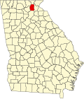
Benefit, Georgia

Last updated

Benefit is an unincorporated community in White County, in the U.S. state of Georgia. [1]

History

A post office called Benefit was established in 1899, and remained in operation until 1906. [2] In 1900, the community had 52 inhabitants. [3]

Related Research Articles

<span class="mw-page-title-main">White County, Georgia</span> County in Georgia, United States

White County is a county located in the northeastern part of the U.S. state of Georgia. As of the 2020 census, the population was 28,003. The county seat is Cleveland. The county was created on December 22, 1857, formerly a part of Habersham County and most likely was named for Newton County Representative David T. White, who helped a Habersham representative successfully attain passage of an act creating the new county.

<span class="mw-page-title-main">Newton County, Georgia</span> County in Georgia, United States

Newton County is a county located in the north central portion of the U.S. state of Georgia. As of the 2020 census, the population was 112,483. The county seat is Covington.

<span class="mw-page-title-main">Barrow County, Georgia</span> County in Georgia, United States

Barrow County is a county located in the north central portion of the U.S. state of Georgia. As of the 2020 Census, the population was 83,505. The county seat is Winder.

<span class="mw-page-title-main">Raynesford, Montana</span> Census-Designated Place in Montana, United States

Raynesford is an unincorporated community in Judith Basin County, Montana, United States. Its elevation is 4,042 feet (1,232 m), and it is located at 47°16′12″N110°43′48″W. The community includes a community center, a catholic church, a fire department, and a post office. The post office was established under the name of "Spion Kop" on March 31, 1906; its name was changed to Raynesford exactly three years later.

<span class="mw-page-title-main">Winston, Georgia</span> Unincorporated community in Georgia, United States

Winston is an unincorporated community, formerly incorporated as a city, in southwestern Douglas County, Georgia, United States.

Mossy Creek is a stream in White and Hall counties in Georgia, and is a tributary of the Chattahoochee River. The creek rises in White County and passes into Hall County approximately one mile south of the White-Hall county line.

Williamsport is an unincorporated community in Morrow County, in the U.S. state of Ohio.

Center is an unincorporated community in Jackson County, in the U.S. state of Georgia.

Dakota is an unincorporated community in Turner County, in the U.S. state of Georgia.

Air Line is an unincorporated community in Hart County, in the U.S. state of Georgia.

Alvin is an unincorporated community in Madison County, in the U.S. state of Georgia.

Arp is an unincorporated community in Banks County, in the U.S. state of Georgia. The community lies about 5 miles (8.0 km) northeast of the county seat at Homer.

Ashland is an unincorporated community in Franklin County, in the U.S. state of Georgia.

Ayersville is an unincorporated community in Stephens County, in the U.S. state of Georgia. A variant name was "Ayers".

Belmont is an unincorporated community in Hall County, in the U.S. state of Georgia.

Blalock is an unincorporated community in Rabun County, in the U.S. state of Georgia.

Blount is an unincorporated community in Monroe County, in the U.S. state of Georgia.

Bowens Mill is an unincorporated community in Ben Hill County, in the U.S. state of Georgia.

Parkertown is an unincorporated community in Hart County, in the U.S. state of Georgia.

White Sulphur Springs is an unincorporated community in Hall County, in the U.S. state of Georgia.

References

  1. U.S. Geological Survey Geographic Names Information System: Benefit, Georgia
  2. "White County". Jim Forte Postal History. Retrieved September 11, 2017.
  3. Candler, Allen Daniel; Evans, Clement Anselm (1906). Georgia: Comprising Sketches of Counties, Towns, Events, Institutions, and Persons. State historical association. p.  169.

34°33′27″N83°43′48″W / 34.55750°N 83.73000°W / 34.55750; -83.73000