Benguela Current Commission

Last updated

The Benguela Current Commission, or BCC, is a multi-sectoral inter-governmental, initiative of Angola, Namibia and South Africa. It promotes the sustainable management and protection of the Benguela Current Large Marine Ecosystem, or BCLME. The BCC was established in January 2007 through the signing of an Interim Agreement between the governments of Angola, Namibia and South Africa. Then, on 18 March 2013, the three governments signed the Benguela Current Convention, an environmental treaty that entrenches the Benguela Current Commission as a permanent inter-governmental organization.

Contents

The BCC is based on the large marine ecosystem (LME) approach to ocean governance. It is focused on the management of shared fish stocks; environmental monitoring; biodiversity and ecosystem health; the mitigation of pollution; and minimizing the impacts of marine mining and oil and gas production. Sound environmental governance and training and capacity building are at the forefront of its agenda.

The BCC provides a vehicle for Angola, Namibia and South Africa to introduce an ecosystem approach to ocean governance. This means that, instead of managing living and non-living resources at the national level, the three countries work together through the BCC, to address the problems that affect the BCLME.

History

Although Angola, Namibia and South Africa each have policies, legislation and structures for managing their individual Exclusive Economic Zones, since the mid-1990s the three countries have promoted a coordinated approach towards the management of the BCLME. [1] Following a historic first meeting between marine scientists from the three countries, which took place in Swakopmund, Namibia, in June 1995, the BCLME Programme was conceived. With the backing of the three countries, and financial and logistical support from the Global Environment Facility (GEF) and the United Nations Development Programme (UNDP), the BCLME Programme was implemented between 2002 and 2008. Its objective was to improve knowledge and understanding of the BCLME and enhance the ability of the three countries to jointly address environmental problems that occur across national borders so that the BCLME may be managed in a coordinated and integrated way. [2] The BCLME Programme was implemented in tandem with BENEFIT, a regional marine science and training programme focused on fisheries and marine resources. [3]

The knowledge generated by the BCLME Programme resulted in an acknowledgement by the governments of Angola, Namibia and South Africa that effective long-term cooperation between them in implementing an ecosystem approach in the BCLME required the establishment of stable institutional arrangements. [4] As a result, the three countries established the Benguela Current Commission.

The convention

On 18 March 2013, the governments of Angola, Namibia and South Africa signed the Benguela Current Convention. The objective of the Convention is to "promote a coordinated regional approach to the long-term conservation, protection, rehabilitation, enhancement and sustainable use of the Benguela Current Large Marine Ecosystem, to provide economic, environmental and social benefits". [4] The Convention is applied in all areas within the national sovereignty and jurisdiction in accordance with the United Nations Convention on the Law of the Sea, bounded by the high water mark along the coasts of the parties. In giving effect to the objective of the Benguela Current Convention, the countries are guided by the following principles:

The Benguela Current Convention will commit the governments of Angola, Namibia and South Africa to:

The Benguela Current Convention also sets out the structure and functions of the Benguela Current Commission, including the roles and responsibilities of its Secretariat and permanent committees. These are the Ecosystem Advisory Committee, Finance and Administration Committee and Compliance Committee. The Convention also stipulates that the decisions and recommendations of the Benguela Current Commission are to be taken by consensus and that the parties are obliged to cooperate to settle disputes. The languages of the Commission are English and Portuguese and the headquarters of the inter-governmental body are in Swakopmund, Namibia. [4]

Ratification

The Benguela Current Convention was ratified by the Government of Namibia in 2013, [5] and by the Government of Angola and the Government of South Africa in 2014. [6]

The Strategic Action Programme

The Fourth Ministerial Conference of the Benguela Current Commission was held in Namibe (now Moçâmedes), Angola in August 2014. At the Conference, ministers and senior government officials representing the fisheries, environment, transport and mining sectors of Angola, Namibia and South Africa, adopted a five-year Strategic Action Programme (SAP). [7] The SAP is a wide-ranging document that:

The SAP reflects the objectives, principles and functions that are set out in the Benguela Current Convention. It provides policy direction for the period 2015 to 2019. The content of the SAP is derived from the Transboundary Diagnostic Analysis (TDA), a scientific and technical assessment that identifies and ranks transboundary problems and proposes remedial actions. A first TDA was developed for the BCLME in 1999 and this document was updated in 2013, following a series of consultative workshops. The SAP is supplemented by an Implementation Plan, an operational document that details the activities required to implement the policy actions. The Implementation Plan provides a framework for the BCC to develop detailed scientific or management projects that help to meet its objectives.

Regional and global importance

The Benguela Current Large Marine Ecosystem (BCLME) extends from east of the Cape of Good Hope, northwards into Angolan waters and encompasses the full extent of Namibia's marine environment. [2] Like the Humboldt, California and Canary current systems, the Benguela is a major coastal upwelling ecosystem and an important centre of marine biodiversity and marine food production. [2] Distinctive bathymetry, hydrography, chemistry and trophodynamics combine to make the BCLME one of the most productive ocean areas in the world; mean annual primary productivity is 1.25 kilograms of carbon per square metre, per year – about six times higher than the North Sea ecosystem. [8]

High productivity occurs as a result of surface waters that are continually fertilized by the upwelling of cold, nutrient-rich water. [9] This cold water moves from depths where there is limited light to the well-lit environment at the surface where conditions are ideal for the rapid growth and division of phytoplankton cells. These single-celled plants proliferate to form dense phytoplankton blooms. It is these episodic but frequent bursts of productivity by phytoplankton that make the BCLME a region of sustained high productivity all year round. [9] The high productivity is, however, in contrast to the relatively low biodiversity of the BCLME. Low biodiversity has been attributed to the extremely variable nature of the marine environment at a range of temporal and spatial scales, which favours generalists over specialists [9]

The Benguela is particularly productive in terms of fisheries resources – especially small pelagic fish – but top predators such as seabirds and marine mammals are also abundant. [9] Commercial fisheries and the extraction of non-living natural resources such as oil and gas, diamonds and other minerals, are the focus of industrial activities in the region. [10] It is estimated that coastal and marine resources contribute approximately US$269 billion per year to the economies of Angola, Namibia and South Africa. [11] Angola is the second largest producer of oil in Sub-Saharan Africa (after Nigeria) and dominates the oil and gas industry in the BCLME. [12] The country's economy is almost entirely dependent on oil production, with oil exports accounting for approximately 98 percent of government revenues in 2011 according to the International Monetary Fund. [12]

Industrial fishing also makes an important contribution to the economy of the region and small-scale artisanal fisheries provide a living for thousands of Angolans and South Africans. [10] In Namibia, more than 20 species are fished commercially and approximately 90% of the catch is exported. [13] The fishing industry employs 13,700 people (2003 figures). [13] There are very few small-scale/artisanal fishers in Namibia, but recreational fishing is a popular sport and a major attraction for coastal tourists. In Angola, at least 25,000 coastal people work as artisanal fishers, while an estimated 80,000 people – mostly women – prepare and sell the artisanal catch and are therefore dependent on fishing for their livelihoods. [10] The South African fishing industry is very diverse. The country's fishing fleet ranges in size from small rock lobster dinghies, to highly sophisticated freezer trawlers. The small pelagic fishery for sardine and anchovy is the largest fishery by volume, while the deep-sea trawling industry is the largest by value. This fishery targets the Cape hakes. Artisanal fishers operate along the entire South African coast, harvesting a wide variety of species including linefish, mussels, oysters, ascidians and common periwinkles. Various species of seaweed form the basis of a small industry that produces alginate products and feed for aquaculture operations. [10]

The nearshore and shelf environments of the Benguela Current region hold rich reserves of minerals, particularly diamonds. [2] Namibia is world-renowned for the gem quality diamonds that occur along the Orange River and both onshore and offshore of the coast. As onshore diamond reserves are depleted, future diamond production will predominantly come from the seabed. Mid-water to deep-water mining operations require sophisticated marine vessels and crawlers that are capable of retrieving diamondiferous gravels/sands from the seafloor. [14] Phosphate deposits found at depths of 180 to 300 m have attracted interest but the Namibian government has announced a moratorium on phosphate mining in order to conduct a study on the potential impacts of mining on the marine ecosystem. [15]

Although the BCLME holds significant aquaculture potential, the industry is underdeveloped. South Africa's aquaculture industry is the most productive of the three countries’. It produces abalone, mussels, oysters, seaweed and prawns, with abalone the most important of these in terms of volume and employment. In Namibia, mussels, oysters, Gracilaria (red seaweed used by the pharmaceutical industry) and abalone are farmed, but the aquaculture industry is dominated by oyster production. [10]

Shipping and marine and coastal tourism are other significant industries in the BCLME, with the ports of Angola, Namibia and South Africa playing a crucial role in the economy of the region. [10] The exceptional natural beauty of the coastal regions, many of which are still pristine by global standards, has also enabled the development of tourism opportunities. [2]

Citations

  1. Hempel, O'Toole & Sweijd 2008, p. 8.
  2. 1 2 3 4 5 O'Toole et al. 2001, pp. 229–251.
  3. Hampton, I. & Sweijd, N. 2008. Achievements and lessons learnt from the Benguela Environment, Fisheries, Interaction and Training (BENEFIT) research programme. African Journal of Marine Science 2008, 30 (3): 541-564Programme)
  4. 1 2 3 4 5 Interim Agreement between the Government of the Republic of Angola and the Government of the Republic of Namibia and the Government of the Republic of South Africa on the establishment of the Benguela Current Commission (doc). 2007. Archived from the original on 2012-05-13.
  5. LME News. Newsletter of the African LME Caucus. Issue 4. December 2013. Namibia ratifies the Benguela Current Convention. Available at http://www.benguelacc.org/index.php/en/large-marine-ecosystems/the-african-lme-caucus
  6. Benguela News. Issue 4. Newsletter of the Benguela Current Commission. 4 October 2014.
  7. Benguela News. Issue 4. Newsletter of the Benguela Current Commission. 4 October 2014. Available at http://www.benguelacc.org/index.php/en/publications
  8. Shannon, L.V. & O'Toole, M.J. 2003. Sustainability of the Benguela: ex Africa semper aliquid novi. In G. Hempel and K. Sherman, eds. Large Marine Ecosystems of the World: Trends in exploitation, protection and research. Elsevier. 227-253
  9. 1 2 3 4 Hempel, O'Toole & Sweijd 2008, pp. 12–17.
  10. 1 2 3 4 5 6 Hempel, O'Toole & Sweijd 2008, pp. 20–23.
  11. SUMAILA, U.R., 2012. Economic Valuation of the Marine and Coastal Resources of the Benguela Current Large Marine Ecosystem, Draft Report, December 2011. Vancouver: University of British Columbia, unpublished.
  12. 1 2 US Energy Information Administration. Available at http://www.eia.gov/countries/cab.cfm?fips=AO
  13. 1 2 FAO.2007. Fishery Country Profile Namibia. Rome, Italy. FAO. Available at http://www.fao.org/fishery/countrysector/FI-CP_NA/en
  14. Geological Survey of Namibia. Available at "Economic Geology Division > Diamonds". Archived from the original on 2006-04-06. Retrieved 2014-05-23.
  15. Phosphate mining banned. The Namibian, 19/09/13. Available at http://www.namibian.com.na/indexx.php?archive_id=114235&page_type=archive_story_detail&page=1%5B%5D

Related Research Articles

Upwelling Replacement by deep water moving upwards of surface water driven offshore by wind

Upwelling is an oceanographic phenomenon that involves wind-driven motion of dense, cooler, and usually nutrient-rich water from deep water towards the ocean surface. It replaces the warmer and usually nutrient-depleted surface water. The nutrient-rich upwelled water stimulates the growth and reproduction of primary producers such as phytoplankton. The biomass of phytoplankton and the presence of cool water in those regions allow upwelling zones to be identified by cool sea surface temperatures (SST) and high concentrations of chlorophyll-a.

Fishery Raising or harvesting fish

Fishery can mean either the enterprise of raising or harvesting fish and other aquatic life; or more commonly, the site where such enterprise takes place. Commercial fisheries include wild fisheries and fish farms, both in freshwater bodies and the oceans. About 500 million people worldwide are economically dependent on fisheries. 171 million tonnes of fish were produced in 2016, but overfishing is an increasing problem — causing declines in some populations.

International waters Water outside of national jurisdiction

The terms international waters or trans-boundary waters apply where any of the following types of bodies of water transcend international boundaries: oceans, large marine ecosystems, enclosed or semi-enclosed regional seas and estuaries, rivers, lakes, groundwater systems (aquifers), and wetlands.

Heavisides dolphin Species of mammal

Heaviside's dolphin, is one of four dolphins in the genus Cephalorhynchus. The small cetacean is endemic to the Benguela ecosystem along the southwest coast of Africa.

Benguela Current Ocean current in the South Atlantic

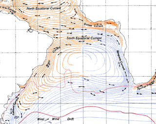
The Benguela Current is the broad, northward flowing ocean current that forms the eastern portion of the South Atlantic Ocean gyre. The current extends from roughly Cape Point in the south, to the position of the Angola-Benguela front in the north, at around 16°S. The current is driven by the prevailing south easterly trade winds. Inshore of the Benguela Current proper, the south easterly winds drive coastal upwelling, forming the Benguela Upwelling System. The cold, nutrient rich waters that upwell from around 200–300 m (656–984 ft) depth in turn fuel high rates of phytoplankton growth, and sustain the productive Benguela ecosystem.

Iona National Park National park in Angola

Iona National Park is the largest national park in Angola. It is situated in the Southwestern corner of the country, in Namibe Province. It is roughly bound by the Atlantic Ocean to the West, an escarpment to the East that marks the beginning of the interior plateau, the Curoca River to the North, and the Cunene River to the South. It is about 200 kilometres (120 mi) south of the city of Namibe and covers 5,850 square miles (15,200 km2) sq. miles.

Large marine ecosystem Oceanic regions

Large marine ecosystems (LMEs) are regions of the world's oceans, encompassing coastal areas from river basins and estuaries to the seaward boundaries of continental shelves and the outer margins of the major ocean current systems. They are relatively large regions on the order of 200,000 km² or greater, characterized by distinct bathymetry, hydrography, productivity, and trophically dependent populations. Productivity in LME protected areas is generally higher than in the open ocean.

Cormac Cullinan is a practising environmental attorney and author based in Cape Town, South Africa. He is a director of the leading South African environmental law firm, Cullinan & Associates Inc, and director of the Wild Law Institute, a non-profit organisation that advocates for Rights of Nature. A former commercial lawyer, he has practiced, taught and written about environmental law and policy since 1992, and has worked in more than 20 countries.

The South East Atlantic Fisheries Organisation (SEAFO) is an organization that maintains controls over fishing and fishing related acts in the Southeastern Atlantic Ocean.

Mercury Island Island off Namibia

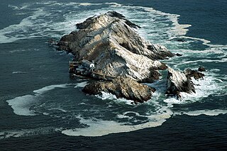
Mercury Island is a small rocky island off The Diamond Coast, Namibia. Despite its small size it is recognised by BirdLife International and other global conservation groups as an Important Bird Area (IBA) for its important coastal seabird breeding.

The Port Management Association of Eastern and Southern Africa (PMAESA) is a non-profit, inter-governmental organization made up of Port Operators, Government Line Ministries, Logistics and Maritime Service Providers and other port and shipping stakeholders from the Eastern, Western and Southern African and Indian Ocean regions.

The Leibniz-Zentrum für Marine Tropenforschung (ZMT) in Bremen, Germany is the only scientific institute in Germany that exclusively investigates tropical and subtropical coastal ecosystems and their significance for nature and humans in an interdisciplinary approach. The mission of ZMT is to provide a scientific basis for the protection and sustainable use of tropical coastal ecosystems by conducting research, capacity development and consulting activities in close cooperation with national and international partners in the tropics. Since its launch in 1991, ZMT has also developed a huge network of research and political partners within the tropics and worldwide, including more than 800 alumni. The institute offers a broad range of research infrastructure, including its own scientific diving centre and laboratories such as the Marine Experimental Ecology Facility (MAREE). ZMT also hosts the Future Earth Coasts (FEC) office, a global network of experts investigating the drivers of global change in coastal zones.

Nils Bang

Nils Daniel Bang was a South African oceanographic scientist who was a pioneer in the study of the fine structure of coastal upwelling systems. In March 1969, Bang initiated, planned and executed South Africa's first truly multi-ship oceanographical research operation, the Agulhas Current Project, along the current's length. Although the research was conducted on a limited budget and with rudimentary equipment, Bang's studies using thousands of closely spaced bathythermograph readings were later corroborated by satellite imagery and airborne radiation thermometry.

Western Indian Ocean Marine Science Association

Western Indian Ocean Marine Science Association (WIOMSA) is a regional professional, non-governmental, non-profit, membership organization, registered in Zanzibar, Tanzania. The organization is dedicated to promoting the educational, scientific and technological development of all aspects of marine sciences throughout the region of Western Indian Ocean, with a view toward sustaining the use and conservation of its marine resources. The association has about 1000 individual members as well as about 50 institutional members from within and outside the region.

Marine ecoregions of the South African exclusive economic zone Geographical regions of similar ecological characteristics

The marine ecoregions of the South African exclusive economic zone are a set of geographically delineated regions of similar ecological characteristics on a fairly broad scale, covering the exclusive economic zone along the South African coast.

The marine protected areas of South Africa are in an area of coastline or ocean within the exclusive economic zone (EEZ) of the Republic of South Africa that is protected in terms of specific legislation for the benefit of the environment and the people who live in and use it. An MPA is a place where marine life can thrive under less pressure than unprotected areas. They are like underwater parks, and this healthy environment can benefit neighbouring areas.

Temperate Southern Africa Biogeographic region of the Earths seas, comprising the temperate waters of southern Africa.

Temperate Southern Africa is a biogeographic region of the Earth's seas, comprising the temperate waters of southern Africa, where the Atlantic Ocean and Indian Ocean meet. It includes the coast of South Africa and Namibia, and reaches into southern Angola. It also includes the remote islands of Amsterdam and Saint-Paul, to the east in the southern Indian Ocean.

The Biodiversity of South Africa is the variety of living organisms within the boundaries of South Africa and its exclusive economic zone. South Africa is a region of high biodiversity in the terrestrial and marine realms. The country is ranked sixth out of the world's seventeen megadiverse countries, and is rated among the top 10 for plant species diversity and third for marine endemism.

Angola–Benguela Front

The Angola - Benguela front (ABF) is a permanent frontal feature situated between 15° and 17°S off the coast of Angola and Namibia, west Africa. It separates the saline, warm and nutrient-poor sea water of the Angola Current from the cold and nutrient-rich sea water associated with the Benguela Current.

The Rocherpan Marine Protected Area is a small coastal conservation region on the West Coast of the Western Cape province, in the territorial waters of South Africa. It is about 25 km north of Velddrif on the road to Elands Bay, north of Dwarskersbos.

References