
Benson County is a county in the U.S. state of North Dakota. As of the 2020 census, the population was 5,964. Its county seat is Minnewaukan. The county was created on March 9, 1883 by the Dakota Territory legislature, and was named for Bertil W. Benson, a Dakota Territory legislator at the time. The county government was organized on June 4, 1884, and its boundary lines were altered by two legislative actions in 1885.

Jodi Benson is an American actress and singer. She is best known for providing the voice of Ariel in Disney's The Little Mermaid (1989), as well as in its its sequel, prequel, and television series spin-off, along with many other Disney works. She is also known for her portrayal of Barbie in the second and third films of the Toy Story franchise (1999–2010), and in the Toy Story Toons short Hawaiian Vacation (2011).
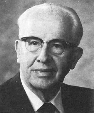
Ezra Taft Benson was an American farmer, government official, and religious leader who served as the 15th United States Secretary of Agriculture during both presidential terms of Dwight D. Eisenhower and as the 13th president of the Church of Jesus Christ of Latter-day Saints from 1985 until his death in 1994.

Ezra Taft Benson was an apostle and a member of the Quorum of the Twelve Apostles of the Church of Jesus Christ of Latter-day Saints.

Alaska's Flag is the state song of Alaska.
Twin Lake or Twin Lakes may refer to:

Ashley Victoria Benson is an American actress and singer. Her accolades include four Teen Choice Awards, a Young Hollywood Award, as well as three People's Choice Award nominations.
Rock Lake is the name of several locations:
Pleasant Lake may refer to:
Henrik Ibsen (1828–1906) was a Norwegian playwright, theatre director, and poet.
Rock Township is a civil township in Benson County, North Dakota, United States. As of the 2000 census, its population was 39.

Benson State Recreation Area is a state park in the U.S. state of Oregon, administered by the Oregon Parks and Recreation Department.
Wood Lake Township is a civil township in Benson County, North Dakota, United States. As of the 2000 census, its population was 440. Wood Lake Township is the second most populous township in Benson County, after Mission Township.
Daniel Benson may refer to:

William Buchanan Benson is an American professional baseball outfielder for the Cincinnati Reds of Major League Baseball (MLB). He has previously played in MLB for the Cleveland Guardians.
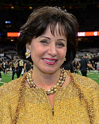
Gayle Marie LaJaunie Bird Benson is an American businesswoman who is the owner of the New Orleans Saints of the National Football League (NFL) and the New Orleans Pelicans of the National Basketball Association (NBA). She became the principal owner of the Saints and Pelicans following the death of her husband, Tom Benson, in 2018.
Locations named White Lake in the U.S. state of New York include:
This page is based on this
Wikipedia article Text is available under the
CC BY-SA 4.0 license; additional terms may apply.
Images, videos and audio are available under their respective licenses.