
Doncaster is a city in South Yorkshire, England. Named after the River Don, it is the administrative centre of the larger City of Doncaster, and is the second largest settlement in South Yorkshire after Sheffield. Noted for its horse racing and railway history, it is situated in the Don Valley on the western edge of the Humberhead Levels and east of the Pennines. The urban subdivision had a population of 113,566 at the 2021 census, whilst the City of Doncaster metropolitan borough had a population of 308,106.

Cleethorpes is a seaside town on the estuary of the Humber in North East Lincolnshire, England with a population of 38,372 in 2020. It has been permanently occupied since the 6th century, with fishing as its original industry, then developing into a resort in the 19th century. Before becoming a unified town, Cleethorpes was made up of the three small villages of Itterby, Oole and Thrunscoe.

The City of Doncaster is a metropolitan borough with city status in South Yorkshire, England. It is named after its principal settlement, Doncaster, and includes the surrounding suburbs of Doncaster as well as numerous towns and villages. The district has large amounts of countryside; at 219 square miles (570 km2), it is the largest metropolitan borough in England by area.

Maltby is a former mining town and civil parish in the Metropolitan Borough of Rotherham, South Yorkshire, England. It was historically in the West Riding of Yorkshire. It is located about 6 miles (10 km) east of Rotherham town centre and 10 miles (16 km) north-east of Sheffield city centre. It forms a continuous urban area with Hellaby, separated from the rest of Rotherham by the M18 motorway. It had a population of 16,688 at the 2011 Census.
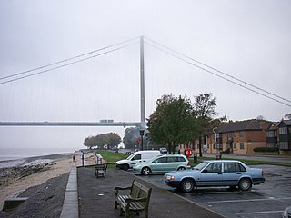
Hessle is a town, civil parish and electoral ward in the East Riding of Yorkshire, England, five miles west of Kingston upon Hull city centre. Geographically it is part of a larger urban area consisting of the city of Kingston upon Hull, the town of Hessle and a number of other villages but is not part of the city. It is on the north bank of the Humber Estuary where the Humber Bridge crosses.

Adwick le Street is a village in the City of Doncaster, South Yorkshire, England. The Adwick ward of Doncaster Metropolitan Borough Council had a population of 15,911 at the 2011 Census. It is situated north-west of Doncaster. Under the 2011 census, the settlement had a population of 10,507.
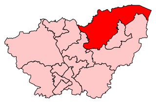
Doncaster North is a constituency in South Yorkshire, England, represented in the House of Commons of the UK Parliament since 2005 by Ed Miliband of the Labour Party. From 2010 until 2015, he was Leader of the Opposition before he lost the 2015 general election to David Cameron and the Conservatives. Part of the red wall, it was formerly a Labour stronghold, until the 2019 general election when it became a Labour-Conservative marginal.

Cadeby is a village and civil parish in the City of Doncaster in South Yorkshire, England. The population at the census of 2011 was 203. It is about five miles west of Doncaster, and four miles east of Mexborough.
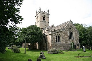
St James' Church, High Melton is a parish church of the Church of England in High Melton, South Yorkshire, England.

Arksey is a village in the City of Doncaster in South Yorkshire, England. It had an estimated population of 1,303 as of 2010. It was the birthplace of the children's writer Barbara Euphan Todd on 9 January 1890. Arksey has four satellite hamlets: Shaftholme, Tilts, Almholme and Stockbridge.

Sprotbrough is a village in the City of Doncaster in South Yorkshire, England, 3 miles (4.8 km) west of Doncaster city centre. With Cusworth to the north, it forms the civil parish of Sprotbrough and Cusworth. Sprotbrough village had a population of 3,321 at the 2011 census; this does not include the area of Newton to the east of the A1(M). The civil parish of Sprotbrough and Cusworth had a population of 12,134, which also includes Cusworth, Newton and part of Scawsby. The electoral ward of Sprotbrough, including numerous rural villages to the north and west, had a population of 11,143.

Warmsworth is a village and civil parish of Doncaster in the City of Doncaster in South Yorkshire, England. Its population was estimated at 3,908 in 2019. The village lies along the A1(M) Doncaster Bypass and the A630. The River Don is close to the village. Sprotbrough, Edlington, Conisbrough, Levitt Hagg and Balby surround Warmsworth. It lies 4 miles from Doncaster.
Scawthorpe is a suburb of Doncaster in South Yorkshire, England on the A638 road. It is split between the city council wards of Roman Ridge and Bentley.

Toll Bar is a semi-rural hamlet in the City of Doncaster local government area, South Yorkshire, England. It is situated on the A19 road, and approximately 3 miles (5 km) north from the town of Doncaster, and adjacent to Bentley. Toll Bar had a population of 1,226 in the 2011 census.
Bentley is a ward in the metropolitan borough of Doncaster, South Yorkshire, England. The ward contains 22 listed buildings that are recorded in the National Heritage List for England. Of these, one is listed at Grade I, the highest of the three grades, and the others are at Grade II, the lowest grade. The ward contains the suburb of Bentley, the villages of Almholme, Arksey, and Toll Bar, and the surrounding area. There is a group of listed buildings in Arksey, including the church, the vicarage, the former school and its wall, a group of almshouses, a hall, and a pinfold. Elsewhere, the listed buildings include another church, another pinfold, houses and cottages, a former watermill, farmhouses and farm buildings, a road causeway, a road bridge, and four mileposts.

The Ea Beck, also spelled Eaubeck or Eau Beck, is a small river in South Yorkshire, England, that flows eastwards into the River Don at Thorpe-in-Balne. The Environment Agency lists the beck as starting at South Elmsall, but mapping lists the beck with several names along its course. The beck has twice flooded areas and villages that it passes through in the 21st century.


