Benton Township, Cheboygan County, Michigan

Last updated

Benton Township, Michigan
Benton Township (Cheboygan), MI location2.png
Location within Cheboygan County
USA Michigan location map.svg
Red pog.svg
Benton Township
Location within the state of Michigan
Coordinates: 45°36′12″N84°24′47″W / 45.60333°N 84.41306°W / 45.60333; -84.41306
Country United States
State Michigan
County Cheboygan
Established1871
Area
  Total62.4 sq mi (161.6 km2)
  Land58.6 sq mi (151.9 km2)
  Water3.7 sq mi (9.7 km2)
Elevation
722 ft (220 m)
Population
 (2010)
  Total3,206
  Density55/sq mi (21.1/km2)
Time zone UTC-5 (Eastern (EST))
  Summer (DST) UTC-4 (EDT)
ZIP code(s)
49721
Area code 231
FIPS code 26-07420 [1]
GNIS feature ID1625916 [2]
Website Official website

Benton Township is a civil township of Cheboygan County in the U.S. state of Michigan. As of the 2010 census, the township population was 3,206. [3]

Contents

History

Benton Township was first organized on March 25, 1871. [4] At that time, it was a small area surrounding Duncan Bay, including the village of Cheboygan. In 1887, Benton expanded to a larger portion of the original Duncan Township.

Geography

Benton Township occupies the northeast corner of Cheboygan County, and is bordered to the north by the South Channel of the Straits of Mackinac opening out into Lake Huron. Presque Isle County is to the east, and Mackinac County is to the north. The city of Cheboygan borders the township on the northwest. The southwest corner of the township is in Mullett Lake, the outlet of which, the Cheboygan River, forms the western border of the township up to the city of Cheboygan. The Black River enters the township from the south and flows northwest to the Cheboygan River at the township's western border.

U.S. Highway 23 follows the northern edge of the township at varying distances from Lake Huron, leading west into Cheboygan and southeast to Rogers City. M-33 runs north–south across the southwest portion of the township, near Mullett Lake.

Unincorporated communities in the township include Cordwood Point along the Lake Huron shoreline, Mullett Lake Woods and Orchard Beach along Mullett Lake, and Alverno near the southern border of the township. Cheboygan State Park is in the northwest corner of the township along the South Channel and Duncan Bay.

According to the United States Census Bureau, the township has a total area of 62.4 square miles (161.6 km2), of which 58.6 square miles (151.9 km2) is land and 3.7 square miles (9.7 km2), or 5.97%, is water. [3]

Demographics

As of the census [1] of 2000, there were 3,080 people, 1,248 households, and 894 families residing in the township. The population density was 52.5 inhabitants per square mile (20.3/km2). There were 1,627 housing units at an average density of 27.7 per square mile (10.7/km2). The racial makeup of the township was 94.12% White, 0.03% African American, 3.60% Native American, 0.23% Asian, 0.06% Pacific Islander, 0.06% from other races, and 1.88% from two or more races. Hispanic or Latino of any race were 0.58% of the population.

There were 1,248 households, out of which 29.3% had children under the age of 18 living with them, 62.7% were married couples living together, 6.3% had a female householder with no husband present, and 28.3% were non-families. 24.8% of all households were made up of individuals, and 10.5% had someone living alone who was 65 years of age or older. The average household size was 2.44 and the average family size was 2.89.

In the township the population was spread out, with 23.6% under the age of 18, 5.7% from 18 to 24, 27.1% from 25 to 44, 27.5% from 45 to 64, and 16.0% who were 65 years of age or older. The median age was 42 years. For every 100 females, there were 103.6 males. For every 100 females age 18 and over, there were 102.5 males.

The median income for a household in the township was $37,818, and the median income for a family was $43,900. Males had a median income of $30,662 versus $21,714 for females. The per capita income for the township was $21,130. About 6.0% of families and 8.8% of the population were below the poverty line, including 12.2% of those under age 18 and 7.2% of those age 65 or over.

Related Research Articles

<span class="mw-page-title-main">Presque Isle County, Michigan</span> County in Michigan, United States

Presque Isle County is a county in the Lower Peninsula of the U.S. state of Michigan. As of the 2020 Census, the population was 12,982. The county seat is Rogers City. The county was authorized by state legislative action on April 1, 1840, but the county government was not established until 1871. The government was reorganized in 1875.

<span class="mw-page-title-main">Mackinac County, Michigan</span> County in Michigan, United States

Mackinac County is a county in the Upper Peninsula of the U.S. state of Michigan. As of the 2020 Census, the population was 10,834. The county seat is St. Ignace. Formerly known as Michilimackinac County, in 1818 it was one of the first counties of the Michigan Territory, as it had long been a center of French and British colonial fur trading, a Catholic church and Protestant mission, and associated settlement.

<span class="mw-page-title-main">Emmet County, Michigan</span> County in Michigan, United States

Emmet County is a county located in the U.S. state of Michigan. It is the northernmost county in the Lower Peninsula. As of the 2020 Census, the population was 34,112, making it the second-most populous county in Northern Michigan. The county seat is Petoskey, which is also the county's largest city.

<span class="mw-page-title-main">Cheboygan County, Michigan</span> County in Michigan, United States

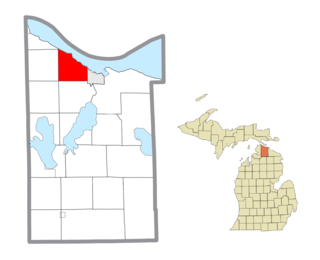
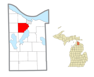
Cheboygan County is a county in the U.S. state of Michigan. As of the 2020 Census, the population was 25,579. The county seat is Cheboygan. The county boundaries were set off in 1840, with land partitioned from Michilimackinac County. The Cheboygan County government was organized and combined with the former Wyandot County in 1853.

<span class="mw-page-title-main">Harrisville, Michigan</span> City in Michigan, United States

Harrisville is a city in the U.S. state of Michigan and the county seat of Alcona County. The population was 493 at the 2010 census, making Harrisville the sixth-smallest city by population in the state of Michigan. The city is surrounded by Harrisville Township but is administratively autonomous. Located on Lake Huron, it is an official Michigan Department of Natural Resources Harbor of Refuge.

<span class="mw-page-title-main">Aloha Township, Michigan</span> Civil township in Michigan, United States

Aloha Township is a civil township of Cheboygan County in the U.S. state of Michigan. As of the 2020 census, the township population was 937.

<span class="mw-page-title-main">Beaugrand Township, Michigan</span> Civil township in Michigan, United States

Beaugrand Township is a civil township of Cheboygan County in the U.S. state of Michigan. As of the 2010 census, the township population was 1,168. The area was settled in 1852.

<span class="mw-page-title-main">Cheboygan, Michigan</span> City in Michigan, United States

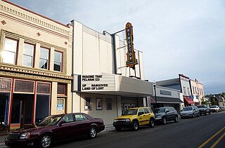
Cheboygan is a city in the U.S. state of Michigan. It is the county seat and largest settlement of Cheboygan County. At the 2020 census, Cheboygan had a population 4,770.

<span class="mw-page-title-main">Grant Township, Cheboygan County, Michigan</span> Civil township in Michigan, United States

Grant Township is a civil township of Cheboygan County in the U.S. state of Michigan. As of the 2010 census, the township population was 846.

<span class="mw-page-title-main">Hebron Township, Michigan</span> Civil township in Michigan, United States

Hebron Township is a civil township of Cheboygan County in the U.S. state of Michigan. As of the 2010 census, the township population was 269.

<span class="mw-page-title-main">Inverness Township, Michigan</span> Civil township in Michigan, United States

Inverness Township is a civil township of Cheboygan County in the U.S. state of Michigan. The population was 2,261 at the 2010 census. It was named after Inverness in Scotland.

<span class="mw-page-title-main">Koehler Township, Michigan</span> Civil township in Michigan, United States

Koehler Township is a civil township of Cheboygan County in the U.S. state of Michigan. The population was 1,283 at the 2010 census.

<span class="mw-page-title-main">Mackinaw Township, Michigan</span> Civil township in Michigan, United States

Mackinaw Township is a civil township of Cheboygan County in the U.S. state of Michigan. The population was 539 at the 2010 census.

<span class="mw-page-title-main">Mullett Township, Michigan</span> Civil township in Michigan, United States

Mullett Township is a civil township of Cheboygan County in the U.S. state of Michigan. The population was 1,312 at the 2010 census. Both the township and Mullett Lake are named for John Mullett, who surveyed much of the area between 1840 and 1843.

<span class="mw-page-title-main">Munro Township, Michigan</span> Civil township in Michigan, United States

Munro Township is a civil township of Cheboygan County in the U.S. state of Michigan. The population was 571 as of the 2010 census,.

<span class="mw-page-title-main">Waverly Township, Cheboygan County, Michigan</span> Civil township in Michigan, United States

Waverly Township is a civil township of Cheboygan County in the U.S. state of Michigan. The population was 457 at the 2010 census.

<span class="mw-page-title-main">Springvale Township, Michigan</span> Civil township in Michigan, United States

Springvale Township is a civil township of Emmet County in the U.S. state of Michigan. The population was 2,146 at the 2020 census.

<span class="mw-page-title-main">St. Ignace, Michigan</span> City in Michigan, United States

St. Ignace is a city in the U.S. state of Michigan and the county seat of Mackinac County. The city had a population of 2,306 at the 2020 census. St. Ignace Township is located just to the north of the city, but the two are administered autonomously.

<span class="mw-page-title-main">Presque Isle Township, Michigan</span> Civil township in Michigan, United States

Presque Isle Township is a civil township of Presque Isle County in the U.S. state of Michigan. The population was 1,656 at the 2010 census.

<span class="mw-page-title-main">Mackinaw City, Michigan</span> Village in Michigan, United States

Mackinaw City is a village at the northernmost point of the Lower Peninsula of Michigan. Divided between Cheboygan and Emmet counties, Mackinaw City is the located at the southern end of the Mackinac Bridge, which carries Interstate 75 over the Straits of Mackinac to the Upper Peninsula. Mackinaw City, along with St. Ignace, serves as an access point to Mackinac Island. For these reasons, Mackinaw City is considered one of Michigan's most popular tourist attractions.

References

  1. 1 2 "U.S. Census website". United States Census Bureau . Retrieved January 31, 2008.
  2. U.S. Geological Survey Geographic Names Information System: Benton Township, Cheboygan County, Michigan
  3. 1 2 "Geographic Identifiers: 2010 Demographic Profile Data (G001): Benton township, Cheboygan County, Michigan". U.S. Census Bureau, American Factfinder. Archived from the original on February 12, 2020. Retrieved September 16, 2014.
  4. W. S. George & Co. (1871). Local and Personal Acts of the Legislature of the State of Michigan Passed at the Regular Session of 1871, Vol. III. Lansing. pp. 104–105.