Bentonia, Mississippi

Last updated

Bentonia, Mississippi
Welcome To Bentonia sign.jpg
Yazoo County Mississippi Incorporated and Unincorporated areas Bentonia Highlighted.svg
Location of Bentonia, Mississippi
Usa edcp location map.svg
Red pog.svg
Bentonia, Mississippi
Location in the United States
Coordinates: 32°38′46″N90°22′20″W / 32.64611°N 90.37222°W / 32.64611; -90.37222
Country United States
State Mississippi
County Yazoo
Area
[1]
  Total1.42 sq mi (3.69 km2)
  Land1.42 sq mi (3.69 km2)
  Water0.00 sq mi (0.00 km2)
Elevation
[2]
197 ft (60 m)
Population
 (2020)
  Total319
  Density224.02/sq mi (86.47/km2)
Time zone UTC-6 (Central (CST))
  Summer (DST) UTC-5 (CDT)
ZIP code
39040
Area code 662
FIPS code 28-05380
GNIS feature ID2405246 [2]
Website townofbentonia.com

Bentonia is a town in Yazoo County, Mississippi, United States. The population as of the 2020 census was 319. [3]

Contents

The Bentonia School of blues singing and guitar-playing is named for Bentonia.

History

Illinois Central Railroad depot in Bentonia Illinois Central Depot, Bentonia, Miss. (25647030214).jpg
Illinois Central Railroad depot in Bentonia

Bentonia began as a postal town along the Illinois Central Railway. It is named for an early resident. Bentonia had a population of 167 in 1900. [4]

Bentonia Blues

The Bentonia School, "Bentonia-style" or "Bentonia Blues" describe a country blues style that originated in and immediately around Bentonia. [5] The annual Bentonia Blues Festival is held in June in Bentonia. [6] The festival's stage is set up in front of the Blue Front Cafe, which is operated by Jimmy "Duck" Holmes who, as a young man, learned the local style from Bentonia Blues musician Jack Owens.

Three markers on the Mississippi Blues Trail are located in Bentonia: one each to musicians Skip James and Jack Owens, and one located at the Blue Front Café. [7] [8] [9] [10]

Geography

According to the United States Census Bureau, the town has a total area of 1.4 square miles (3.6 km2), all land.

Demographics

Historical population
CensusPop.Note
1880 180
1940 440
1950 49612.7%
1960 5113.0%
1970 5446.5%
1980 518−4.8%
1990 390−24.7%
2000 50028.2%
2010 440−12.0%
2020 319−27.5%
U.S. Decennial Census [11]
2010 [12] 2020 [13]

2020 census

Bentonia town, Mississippi – Demographic Profile
(NH = Non-Hispanic)
Race / EthnicityPop 2010 [12] Pop 2020 [13] % 2010% 2020
White alone (NH)28620165.00%63.01%
Black or African American alone (NH)1489233.64%28.84%
Native American or Alaska Native alone (NH)000.00%0.00%
Asian alone (NH)010.00%0.31%
Pacific Islander alone (NH)000.00%0.00%
Some Other Race alone (NH)100.23%0.00%
Mixed Race/Multi-Racial (NH)3250.68%7.84%
Hispanic or Latino (any race)200.45%0.00%
Total440319100.00%100.00%

Note: the US Census treats Hispanic/Latino as an ethnic category. This table excludes Latinos from the racial categories and assigns them to a separate category. Hispanics/Latinos can be of any race.

2000 Census

Bentonia's largest population count, 544, was recorded in 1970. Bentonia had sixty fewer residents in 2010 compared to 2000, [14] and the 2015 estimate is another fourteen fewer. [15] As of the census [16] of 2000, there were 500 people, 203 households, and 130 families residing in the town. The population density was 366.0 inhabitants per square mile (141.3/km2). There were 214 housing units at an average density of 156.6 per square mile (60.5/km2). The racial makeup of the town was 62.80% White, 35.80% African American, 0.20% Asian, 0.20% from other races, and 1.00% from two or more races. Hispanic or Latino of any race were 0.40% of the population.

There were 203 households, out of which 29.6% had children under the age of 18 living with them, 38.9% were married couples living together, 21.7% had a female householder with no husband present, and 35.5% were non-families. 33.5% of all households were made up of individuals, and 16.3% had someone living alone who was 65 years of age or older. The average household size was 2.46 and the average family size was 3.15.

In the town, the population was spread out, with 25.2% under the age of 18, 7.8% from 18 to 24, 25.6% from 25 to 44, 23.8% from 45 to 64, and 17.6% who were 65 years of age or older. The median age was 40 years. For every 100 females, there were 79.9 males. For every 100 females age 18 and over, there were 76.4 males.

The median income for a household in the town was $21,458, and the median income for a family was $39,583. Males had a median income of $28,000 versus $26,875 for females. The per capita income for the town was $12,440. About 23.3% of families and 27.4% of the population were below the poverty line, including 36.5% of those under age 18 and 22.2% of those age 65 or over.

Transportation

Amtrak’s City of New Orleans , which operates between New Orleans and Chicago, passes through the town on CN tracks, but makes no stop. The nearest station is located in Yazoo City, 16 miles (26 km) to the north.

Education

The Town of Bentonia is served by the Yazoo County School District. [17] Residents are zoned to Bentonia Gibbs Elementary School, Yazoo County Middle School, and Yazoo County High School.

Notable people

Related Research Articles

<span class="mw-page-title-main">Yazoo County, Mississippi</span> County in Mississippi, United States

Yazoo County is a county located in the U.S. state of Mississippi. As of the 2020 census, the population was 26,743. The county seat is Yazoo City. It is named for the Yazoo River, which forms its western border. Its name is said to come from a Choctaw language word meaning "River of Death".

<span class="mw-page-title-main">Beulah, Mississippi</span> Town in Mississippi, United States

Beulah is a town in Bolivar County, Mississippi, United States. Per the 2020 census, the population was 242.

<span class="mw-page-title-main">Boyle, Mississippi</span> Town in Mississippi, United States

Boyle is a town in Bolivar County, Mississippi, United States. The population was 650 at the 2010 census.

<span class="mw-page-title-main">Merigold, Mississippi</span> Town in Mississippi, United States

Merigold is a town in Bolivar County, Mississippi, United States. Per the 2020 census, the population was 379.

<span class="mw-page-title-main">Renova, Mississippi</span> Town in Mississippi, United States

Renova is a town in Bolivar County, Mississippi, United States.Per the 2020 census, the population was 676. The community was founded by African Americans and remains predominantly African American.

<span class="mw-page-title-main">Rosedale, Mississippi</span> City in Mississippi, United States

Rosedale is a city in Bolivar County, Mississippi, United States. The population was 1,873 at the 2010 census, down from 2,414 in 2000. Located in an agricultural area, the city had a stop on the Yazoo and Mississippi Valley Railroad, which carried many migrants north out of the area in the first half of the 20th century.

<span class="mw-page-title-main">Shelby, Mississippi</span> City in Mississippi, United States

Shelby is a city in Bolivar County, Mississippi, United States. The population was 2,229 at the 2010 census, down from 2,926 in 2000. The town of Shelby was established in 1853 by Tom Shelby, who had purchased a block of land there from the federal government.

<span class="mw-page-title-main">Bruce, Mississippi</span> Town in Mississippi, United States

Bruce is a town situated along the Skuna River in Calhoun County, Mississippi, United States. As of the 2020 census, it had a population of 1,707.

<span class="mw-page-title-main">Friars Point, Mississippi</span> Town in Mississippi, United States

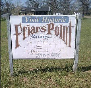
Friars Point is a town in Coahoma County, Mississippi, United States. Per the 2020 census, the population was 896. Situated on the Mississippi River, Friars Point was once a busy port town, and remains the only place in Coahoma County with public access to the river's shore.

<span class="mw-page-title-main">Bolton, Mississippi</span> Town in Mississippi, United States

Bolton is a town in Hinds County, Mississippi, United States. The population was 567 at the 2010 census, down from 629 at the 2000 census. It is part of the Jackson Metropolitan Statistical Area.

<span class="mw-page-title-main">Edwards, Mississippi</span> Town in Mississippi, United States

Edwards is a town in Hinds County, Mississippi, United States. The population was 1,034 at the 2010 census, down from 1,347 at the 2000 census. It is part of the Jackson Metropolitan Statistical Area.

<span class="mw-page-title-main">Cruger, Mississippi</span> Town in Mississippi, United States

Cruger is a town in Holmes County, Mississippi, United States. Per the 2020 census, the population was 268.

<span class="mw-page-title-main">Goodman, Mississippi</span> Town in Mississippi, United States

Goodman is a town in southeastern Holmes County, Mississippi, United States. Per the 2020 census, the population was 1,258.

<span class="mw-page-title-main">Itta Bena, Mississippi</span> City in Mississippi, United States

Itta Bena is a city in Leflore County, Mississippi, United States. The population was 2,049 at the 2010 census. The town's name is derived from the Choctaw phrase iti bina, meaning "forest camp". Itta Bena is part of the Greenwood, Mississippi micropolitan area. It developed as a trading center of an area of cotton plantations.

<span class="mw-page-title-main">Morgan City, Mississippi</span> Town in Mississippi, United States

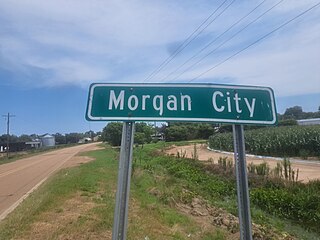
Morgan City, Mississippi is a town in Leflore County along Mississippi Highway 7. The population was 255 at the 2010 census, down from 305 at the 2000 census. It is part of the Greenwood, Mississippi micropolitan area.

<span class="mw-page-title-main">Forest, Mississippi</span> City in Mississippi, United States

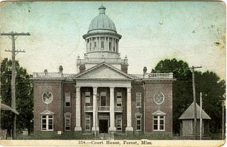
Forest is a city and the county seat of Scott County, Mississippi, United States. The population was 5,684 at the 2010 census and the population is a minority-majority.

<span class="mw-page-title-main">Moorhead, Mississippi</span> City in Mississippi, United States

Moorhead is a city in Sunflower County, Mississippi, United States. As of the 2010 census, the city population was 2,405.

<span class="mw-page-title-main">Eden, Mississippi</span> Village in Mississippi, United States

Eden is a village in Yazoo County, Mississippi. Per the 2020 Census, the population was 133.

<span class="mw-page-title-main">Satartia, Mississippi</span> Village in Mississippi, United States

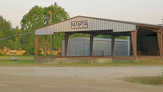
Satartia is a village in Yazoo County, Mississippi. Per the 2020 Census, the population was 41, Mississippi's smallest incorporated municipality by population.

<span class="mw-page-title-main">Jackson–Vicksburg–Brookhaven combined statistical area</span>

The Jackson–Vicksburg–Brookhaven, MS Combined Statistical Area is made up of eight counties in central Mississippi and consists of the Jackson Metropolitan Statistical Area, the Brookhaven, MS Micropolitan Statistical Area, the Vicksburg micropolitan area, and the Yazoo City Micropolitan Statistical Area. The 2010 census placed the Jackson–Vicksburg–Brookhaven CSA population at 650,764, although as of 2019, it's estimated to have increased to 666,318.

References

  1. "2020 U.S. Gazetteer Files". United States Census Bureau. Retrieved July 24, 2022.
  2. 1 2 U.S. Geological Survey Geographic Names Information System: Bentonia, Mississippi
  3. "Bentonia town, Mississippi". United States Census Bureau . Retrieved March 13, 2022.
  4. Rowland, Dunbar (1907). Mississippi: Comprising Sketches of Counties, Towns, Events, Institutions, and Persons, Arranged in Cyclopedic Form. Vol. 1. Southern Historical Publishing Association. p. 234.
  5. "Bentonia Blues - unique, haunting, country blues still heard in Bentonia, Mississippi". bentoniablues.com. Retrieved August 20, 2009.
  6. "The Official Bentonia Blues Festival Webpage". bentoniablues.com. Retrieved August 20, 2009.
  7. "Mississippi Blues Commission - Blues Trail". www.msbluestrail.org. Retrieved May 27, 2008.
  8. "Blue Front Cafe". www.msbluestrail.org. Retrieved March 20, 2021.
  9. "Skip James". www.msbluestrail.org. Retrieved March 20, 2021.
  10. "Jack Owens". www.msbluestrail.org. Retrieved March 20, 2021.
  11. "Decennial Census of Population and Housing by Decades". US Census Bureau.
  12. 1 2 "P2 HISPANIC OR LATINO, AND NOT HISPANIC OR LATINO BY RACE – 2010: DEC Redistricting Data (PL 94-171) – Bentonia town, Mississippi". United States Census Bureau .
  13. 1 2 "P2 HISPANIC OR LATINO, AND NOT HISPANIC OR LATINO BY RACE – 2020: DEC Redistricting Data (PL 94-171) – Bentonia town, Mississippi". United States Census Bureau .
  14. "Bentonia, MS Population - Census 2010 and 2000 Interactive Map, Demographics, Statistics, Quick Facts - CensusViewer". censusviewer.com. Retrieved March 20, 2021.
  15. "Annual Estimates of the Resident Population for Incorporated Places: April 1, 2010 to July 1, 2015". Archived from the original on June 2, 2016. Retrieved July 2, 2016.
  16. "U.S. Census website". United States Census Bureau . Retrieved January 31, 2008.
  17. "2020 CENSUS - SCHOOL DISTRICT REFERENCE MAP: Yazoo County, MS" (PDF). U.S. Census Bureau. Archived (PDF) from the original on August 1, 2022. Retrieved July 31, 2022. - Text list