Turkmenistan is a landlocked country in Central Asia, bordering the Caspian Sea to the west, Iran and Afghanistan to the south, Uzbekistan to the north-east, and Kazakhstan to the north-west. It is the southernmost republic of the Commonwealth of Independent States (CIS), the loose federation created at the end of 1991 by most of the Post-Soviet states.
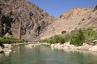
The Hari River or Herat River or Tejen River is a river flowing 1,100 kilometres (680 mi) from the mountains of central Afghanistan to Turkmenistan, where it forms the Tejen oasis and disappears in the Karakum Desert. In its lower course, the river forms a northern part of the border between Afghanistan and Iran, and a southeastern part of the border between Turkmenistan and Iran.

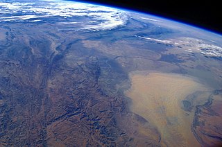
The Karakum Desert, also spelled Kara-Kum and Gara-Gum, is a desert in Central Asia. Its name in Turkic languages means "black sand": "kum" means sand; "kara" is a contraction of garaňky: "dark" or may pre-date that in this language family. This refers to the shale-rich sand generally beneath the sand of much of the desert. It occupies about 70 percent, 350,000 km2 (140,000 sq mi), of Turkmenistan.

Turkmenistan is a landlocked country in Central Asia bordered by Kazakhstan to the northwest, Uzbekistan to the north, east and northeast, Afghanistan to the southeast, Iran to the south and southwest and the Caspian Sea to the west. Ashgabat is the capital and largest city. It is one of the six independent Turkic states. The population is about seven million and is thus the lowest of the Central Asian republics, and Turkmenistan is one of the most sparsely populated nations in Asia.

Mary Region is one of five provinces in Turkmenistan. It is located in the south-east of the country, bordering Afghanistan. Its capital is the city of Mary. Its area is 87,150 km2 (33,650 sq mi) and population 1,480,400. The average population density is about 15 persons per square kilometer, but it reaches 150–200 per square kilometer in the most developed oases.

The Karakum Canal in Turkmenistan is one of the largest irrigation and water supply canals in the world. Started in 1954, and completed in 1988, it is navigable over much of its 1,375-kilometre (854 mi) length, and carries 13 cubic kilometres (3.1 cu mi) of water annually from the Amu-Darya River across the Karakum Desert in Turkmenistan. The canal opened up huge new tracts of land to agriculture, especially to cotton monoculture heavily promoted by the Soviet Union, and supplying Ashgabat with a major source of water. The canal is also a major factor leading to the Aral Sea environmental disaster. The Soviet regime planned to at some time extend the canal to the Caspian Sea.
Environmental issues in Turkmenistan are most visible in three significant areas: desertification, the drying of the Aral Sea, and chemical pollution. All three of these areas are directly linked to agricultural practices in the country.
Protected areas of Turkmenistan include nine nature reserves (zapovednik) and 13 sanctuaries (zakaznik) with a total area of 19,750 km2 or more than 4% of Turkmenistan's territory.

Repetek Biosphere State Reserve, often referred to as Repetek Nature or Desert Reserve, is a desert nature reserve (zapovednik) of Turkmenistan, located in Lebap Province, East Karakum Desert, near Amu Darya. It is located approximately 70 km (43 mi) south from Türkmenabat and is known for its zemzen. Established in 1928 for the study and preservation of a sand-desert ecosystem, it covers an area of 346 km2 (134 sq mi).
Gaplaňgyr or Kaplankyr is a mountain plateau and nature reserve (zapovednik) of northern Turkmenistan. It was established in 1979.
Bagtyýarlyk is a large contractual PSA territory consisting of several natural gas fields located in Lebap Province of Turkmenistan. It literally means happiness in Turkmen language. Bagtyyarlyk constitutes the bigger part of the gas rich Sagkenar area and includes Saman- Depe and Altyn Asyr fields.
The list of Turkmenistan-related articles is below

The Darvaza gas crater, also known as the Door to Hell or Gates of Hell, or, officially, the Shining of Karakum, is a burning natural gas field collapsed into a cavern near Darvaza, Turkmenistan. The floor and especially rim of the crater are illumined by hundreds of natural gas fires. The crater has been burning for an unknown period of time, as how the crater formed and ignited remains unknown.
Turkmenistan is a country with large potential for an expanded tourism industry. Many of its Central Asian cities were main points of trade on the Silk Road, linking Eastern and Western civilizations. Many neighboring countries promote their countries based on their location along the Great Silk Road. Tourism has grown rapidly in recent years. Tourists from abroad are deterred by the restrictive visa policy regime with all countries of the world. Tourism is regulated by the Tourism Committee of Turkmenistan.
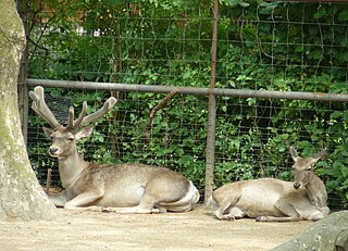
The wildlife of Turkmenistan is the flora and fauna of Turkmenistan, and the natural habitats in which they live. Turkmenistan is a country in Central Asia to the east of the Caspian Sea. Two thirds of the country is hot dry plains and desert, and the rest is more mountainous. Very little rain falls in summer and the chief precipitation occurs in the southern part of the country in the winter and spring. The Caspian coast has milder winters.

The Central Asian southern desert ecoregion is an arid but ecologically active region between the east coast of the Caspian Sea and steppes at the base of the mountains of central Asia. Most of Turkmenistan and eastern Uzbekistan is in this ecoregion. The winters are milder than in the cold desert to the north, and a large number of endemic species have adapted to living in the particular climate and soil of the region. As with sandy deserts in general, the region is notable for high numbers of endemic species of reptiles and insects.

The Kopet Dag woodlands and forest steppe ecoregion coincides with the Kopet Dag mountains, straddling the southern border of Turkmenistan and the northeastern border of Iran. The region is one of high biodiversity, as it includes a full range of altitude zones, and variety of habitats included juniper-wooded slopes, montane grasslands, and tugay.
Silk Roads: Zarafshan-Karakum Corridor is a UNESCO World Heritage Site which covers the Zarafshan-Karakum portion of the ancient Silk Road and historical sites along the route. On September 17, 2023, UNESCO designated a 886 km stretch of the Silk Road network in Central Asia as a World Heritage site. The corridor spans Tajikistan, Turkmenistan and Uzbekistan, includes 31 sites.


