Berg, Lower Austria

Last updated
Berg
Kostol v Bergu.JPG
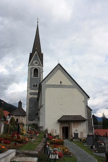
Church of Saint Anne
AUT Berg COA.jpg
Coat of arms
Austria adm location map.svg
Red pog.svg
Berg
Location within Austria
Coordinates: 48°6′N17°2′E / 48.100°N 17.033°E / 48.100; 17.033 Coordinates: 48°6′N17°2′E / 48.100°N 17.033°E / 48.100; 17.033
Country Austria
State Lower Austria
District Bruck an der Leitha
Government
   Mayor Andreas Hammer (SPÖ)
Area
[1]
  Total9.46 km2 (3.65 sq mi)
Elevation
154 m (505 ft)
Population
 (2018-01-01) [2]
  Total861
  Density91/km2 (240/sq mi)
Time zone UTC+1 (CET)
  Summer (DST) UTC+2 (CEST)
Postal code
2413
Area code 02143
Website www.gemeindeberg.at
Passport stamp from the border before Slovakia joined the Schengen Area Bergpassportstamp.jpg
Passport stamp from the border before Slovakia joined the Schengen Area

Berg is a town in the district of Bruck an der Leitha in Lower Austria in Austria. It, along with neighboring Wolfsthal were part of the municipality of Wolfsthal-Berg until 1996.

Lower Austria State of Austria

Lower Austria is the northeasternmost of the nine states of Austria. Since 1986, the capital of Lower Austria has been St. Polten, the most recently designated capital in Austria. Previously, Lower Austria's capital was Vienna, even though Vienna has not officially been part of Lower Austria since 1921. With a land area of 19,186 km2 (7,408 sq mi) and a population of 1.612 million people, Lower Austria is the country's largest state; it is the second most populous after the federal state of Vienna. Other main cities are Amstetten, Krems an der Donau and Wiener Neustadt.

Austria Federal republic in Central Europe

Austria, officially the Republic of Austria, is a country in Central Europe comprising nine federated states. Its capital, largest city and one of nine states is Vienna. Austria has an area of 83,879 km2 (32,386 sq mi), a population of nearly nine million people and a nominal GDP of $477 billion. It is bordered by the Czech Republic and Germany to the north, Hungary and Slovakia to the east, Slovenia and Italy to the south, and Switzerland and Liechtenstein to the west. The terrain is landlocked and highly mountainous, lying within the Alps; only 32% of the country is below 500 m (1,640 ft), and its highest point is 3,798 m (12,461 ft). The majority of the population speaks local Bavarian dialects as their native language, and German in its standard form is the country's official language. Other regional languages are Hungarian, Burgenland Croatian, and Slovene.

Wolfsthal Place in Lower Austria, Austria

Wolfsthal is a town in the district of Bruck an der Leitha in Lower Austria in Austria. It along with neighboring Berg were part of the municipality of Wolfsthal-Berg until 1996. It is the end of the line for S7 Vienna S-Bahn trains.

There is a border crossing into Slovakia, with the Bratislava suburb of Petržalka across the border. Since December 21, 2007, no more checks are conducted at the crossing with Slovakia joining the Schengen Area.

Slovakia Republic in Central Europe

Slovakia, officially the Slovak Republic, is a landlocked country in Central Europe. It is bordered by Poland to the north, Ukraine to the east, Hungary to the south, Austria to the west, and the Czech Republic to the northwest. Slovakia's territory spans about 49,000 square kilometres (19,000 sq mi) and is mostly mountainous. The population is over 5.4 million and consists mostly of Slovaks. The capital and largest city is Bratislava, and the second-largest city is Košice. The official language is Slovak.

Bratislava Capital city in Slovakia

Bratislava is the capital of Slovakia. With a population of about 430,000, it is one of the smaller capitals of Europe but still the country's largest city. The greater metropolitan area is home to more than 650,000 people. Bratislava is in southwestern Slovakia, occupying both banks of the River Danube and the left bank of the River Morava. Bordering Austria and Hungary, it is the only national capital that borders two sovereign states.

Petržalka Borough in Slovakia

Petržalka is the largest borough of Bratislava, the capital of Slovakia. Situated on the right bank of the river Danube, the area shares a land border with Austria, and is home to around 100,000 people.

Geography

Berg lies in the foothills of the Hundsheimer mountains, at the foot of the Königswarte (344 m).

Related Research Articles

Weiden an der March Place in Lower Austria, Austria

Weiden an der March is a municipality in the district of Gänserndorf in Lower Austria, Austria.

Klingenbach Place in Burgenland, Austria

Klingenbach is a town in the Eisenstadt-Umgebung district in the Austrian state of Burgenland. It is located near the border with Hungary with a border crossing into Sopron.

Kittsee Place in Burgenland, Austria

Kittsee is an Austrian municipality in the District of Neusiedl am See, Burgenland.

Raabs an der Thaya Place in Lower Austria, Austria

Raabs an der Thaya is a municipality with 3,114 inhabitants in Waidhofen an der Thaya (district) in the Waldviertel of Lower Austria, near the Austrian border with the Czech Republic. About 27.6 percent of the municipality is forested.

Nickelsdorf Place in Burgenland, Austria

Nickelsdorf is a town in the district of Neusiedl am See in the Austrian state of Burgenland.

Bruckneudorf Place in Burgenland, Austria

Bruckneudorf is a small town in the district of Neusiedl am See in the federal state of Burgenland in Austria, neighbouring Bruck an der Leitha. Its name means bridge new village, whereas the Hungarian version means royal bridge, and the royal refers to King Francis I. Historically and geographically, Bruckneudorf represents the extension of the Austrian town of Bruck an der Leitha over the Austrian border into Hungary. This border, symbolised by the river Leitha, separated the Austrian Empire from the Kingdom of Hungary. Its main current national significance derives from the Bruckneudorf military exercise ground of the Austrian federal army. Currently it is also the site of Bruck an der Leitha railway station, an important railway station near the borders with Hungary and Slovakia, a stop for nearly all the international trains that pass through it.

Schachendorf Place in Burgenland, Austria

Schachendorf is a town in the district of Oberwart in Burgenland in southeast Austria. According to the last census, 73% of the population are members of the Burgenland Croat minority, and 5% belong to the Hungarian minority.

Berg im Drautal Place in Carinthia, Austria

Berg im Drautal is a village and municipality in the district of Spittal an der Drau in the Austrian state of Carinthia.

Ruden, Austria Place in Carinthia, Austria

Ruden is a town in the district of Völkermarkt in the Austrian state of Carinthia.

Pottenstein, Austria Place in Lower Austria, Austria

Pottenstein is a town in the district of Baden in Lower Austria in Austria.

Angern an der March Place in Lower Austria, Austria

Angern an der March is a market town in the district of Gänserndorf in the Austrian state of Lower Austria. The municipality consists of the Katastralgemeinden Angern, Grub, Mannersdorf, Ollersdorf and Stillfried.

Drösing Place in Lower Austria, Austria

Drösing is a town in the district of Gänserndorf in the Austrian state of Lower Austria.

Dürnkrut, Austria Place in Lower Austria, Austria

Dürnkrut is a market town in the district of Gänserndorf in the Austrian state of Lower Austria. Castle Dürnkrut (pictured) is the most famous landmark of the town. The town is agricultural with some noteworthy businesses. Crops grown in the flatter areas are canola, corn, sunflowers and sugar beets. The rolling hils are planted with wine grapes by local vintners.

Hohenau an der March Place in Lower Austria, Austria

Hohenau an der March is a town in the district of Gänserndorf in the Austrian state of Lower Austria, close to Vienna and the borders with the Czech Republic and Slovakia.

Marchegg Place in Lower Austria, Austria

Marchegg is a town in the district of Gänserndorf in the Austrian state of Lower Austria near the Slovak border. It is near Lake Bernhardsthal.

Ringelsdorf-Niederabsdorf Place in Lower Austria, Austria

Ringelsdorf-Niederabsdorf is a town in the district of Gänserndorf in the Austrian state of Lower Austria.

Zirl, Tyrol Place in Tyrol, Austria

Zirl is a market town in the district of Innsbruck-Land in the Austrian state of Tyrol located 10 km west of Innsbruck at the bottom of a pass up the side of the Zirler Berg, leading to Seefeld and ultimately to Germany. The location was mentioned in documents in 799 for the first time. Zirl was damaged several times by floods and fires but nevertheless the population has increased in recent years. The status "Market town" was received in 1984.

Ulrichsberg Place in Upper Austria, Austria

Ulrichsberg is a municipality in the district of Rohrbach in the Austrian state of Upper Austria.

Berg im Attergau Place in Upper Austria, Austria

Berg im Attergau is a municipality in the district of Vöcklabruck in the Austrian state of Upper Austria.

References

  1. "Dauersiedlungsraum der Gemeinden Politischen Bezirke und Bundesländer - Gebietsstand 1.1.2018". Statistics Austria. Retrieved 10 March 2019.
  2. "Einwohnerzahl 1.1.2018 nach Gemeinden mit Status, Gebietsstand 1.1.2018". Statistics Austria. Retrieved 9 March 2019.