Bergeggi (island)

Last updated
Isola Bergeggi
Isola di Bergeggi.JPG
Geography
Location Ligurian Sea
Coordinates 44°14′04″N8°26′42″E / 44.234391°N 8.444915°E / 44.234391; 8.444915 Coordinates: 44°14′04″N8°26′42″E / 44.234391°N 8.444915°E / 44.234391; 8.444915
Area0.08 km2 (0.031 sq mi)
Highest elevation53 m (174 ft)
Administration
Italy
Region Liguria
Province Savona
Communes Bergeggi
Demographics
Population0

Bergeggi is an island which lies in the Ligurian Sea off the coast near the village of Bergeggi in the Province of Savona, Liguria, Italy.

Contents

Geography

The island is around 8 hectares [1] and its highest point is at 53 m. [2] Punta Predani, a promontory on the mainland, is just a few hundreds metres from the island.

History

Bergeggi from Punta Predani Isola Bergeggi.jpg
Bergeggi from Punta Predani

The island bears evidences of a proto-historical Ligures' settlement. On its summit stands a watch tower and remains of a 4th-century church devoted to St. Eugenius. [3]

In 992 the bishop of Savona established a monastery on the island, also devoted to the saint, which was later donated to Lérins Abbey's monks. The monastery's ruins are still visible on the island.

Nature conservation

The island with its surrounding marine area is protected as Riserva naturale regionale di Bergeggi, established in 1985 by the Legge Regionale Liguria n. 10 - Istituzione della riserva naturale regionale di Bergeggi. [4] It is also included in a SIC (Site of Community Importance) called Isola Bergeggi - Punta Predani (code IT1323202). [5]

Among many interesting species living in the maquis shrubland covering most of the small island there are Campanula sabatia and Euphorbia dendroides .

Bibliography

See also

Related Research Articles

<span class="mw-page-title-main">Sassello</span> Comune in Liguria, Italy

Sassello is a comune (municipality) in the Province of Savona in the Italian region Liguria, located about 58 kilometres (36 mi) west of Genoa and about 26 kilometres (16 mi) north of Savona in the northern side of the Ligurian Apennines. It is the birthplace of Blessed Chiara Badano.

The Diocese of Luni was a Roman Catholic bishopric with its seat in Luni, Liguria, northwestern Italy. The bishop and cathedral chapter moved to Sarzana in the 12th century; the move was formalised in 1201. Though the bishops of Luni had been resident at Sarzana long before the official transfer of the cathedral, the diocese and bishop continued to use the name of Luni in their titles down to 1465, when the name of Sarzana was added to both.

<span class="mw-page-title-main">Gallinara</span>

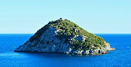
Gallinara or Isola d'Albenga is a small private island that lies in the Ligurian Sea off the coast of Albenga in the Province of Savona, Liguria, northern Italy. It is known for its unique shape, resembling a turtle.

<span class="mw-page-title-main">Bric delle Camere</span> Mountain in Italy

Bric delle Camere is a mountain in northern Italy, part of the Ligurian Apennines. It is located in the provinces of Genoa and Alessandria. It lies at an altitude of 1016 metres.

<span class="mw-page-title-main">Monte Carmo di Loano</span> Mountain in Italy

Monte Carmo di Loano is a mountain in Liguria, northern Italy, part of the Ligurian Prealps. It is located in the province of Savona. It lies at an altitude of 1389 metres.

<span class="mw-page-title-main">Monte Reixa</span> Mountain in Liguria, Italy

Monte Reixa is a mountain in Liguria, northern Italy, part of the Ligurian Apennines.

<span class="mw-page-title-main">Ronco di Maglio</span> Mountain in Italy

Ronco di Maglio is a mountain in Liguria, northern Italy, part of the Ligurian Prealps.

<span class="mw-page-title-main">Monte Settepani</span> Mountain in Italy

Monte Settepani is 1,386 metres high mountain in Liguria, northern Italy, part of the Ligurian Prealps.

<i>Alta Via dei Monti Liguri</i>

The Alta Via dei Monti Liguri is a long-distance waymarked hiking trail in the Italian region of Liguria. In about 440 kilometres (270 mi) and 44 day hikes, it runs through the arc formed by Ligurian Alps and Ligurian Apennines from Ventimiglia to Ceparana.

<span class="mw-page-title-main">Centa (river)</span> Italian river

The Centa is a very short Italian river in the province of Savona.

The Antola Natural Regional Park is a natural park in Metropolitan City of Genoa. It gets the name from the highest mountain of the area, Monte Antola.

<span class="mw-page-title-main">Monte Tobbio</span> Mountain in Italy

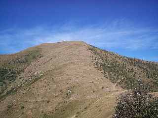
Monte Tobbio is a 1092 metres high mountain of the Apennines, located in the Italian region of Piedmont.

<span class="mw-page-title-main">Parco naturale delle Capanne di Marcarolo</span>

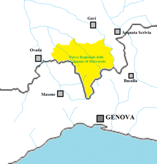
The Capanne di Marcarolo Natural Regional Park is a natural park in the province of Alessandria. It gets the name from a small village in the protected area, Capanne di Marcarolo.

<span class="mw-page-title-main">Lago dell'Antenna</span> Body of water

Lago dell'Antenna is an artificial lake in north-west Italy, located in the Genoa (Liguria). Concerned comunes are Urbe and Sassello.

<span class="mw-page-title-main">Rocca Barbena</span> Mountain in Italy

Rocca Barbena is a 1,142-metre (3,747 ft) high mountain in the Ligurian Prealps in Italy.

<span class="mw-page-title-main">Giara di Rezzo</span> Stream in Liguria, Italy

The Giara di Rezzo is a 14-kilometre (8.7 mi) stream of Liguria, Italy.

<span class="mw-page-title-main">Carmo di Brocchi</span> Mountain in Italy

Carmo di Brocchi is a 1,610-metre (5,282 ft) mountain of the Ligurian Alps, in Italy.

<span class="mw-page-title-main">Monte Alpesisa</span> Mountain in Italy

Monte Alpesisa is a 989 metres high mountain in the Ligurian Apennines, in Italy.

<span class="mw-page-title-main">Monte Peso Grande</span> Mountain in Italy

Monte Peso Grande o Castell'Ermo (1.092 m) is a mountain of the Ligurian Prealps, the eastern section of the Ligurian Alps.

<span class="mw-page-title-main">Monte Camulera</span> Mountain in Italy

The Monte Camulera is a mountain of the Ligurian Prealps, the eastern section of the Ligurian Alps.

References

  1. Parchi naturali di montagna, di pianura, di mare, Giuseppe A. Staluppi et al., Grafo, 1994
  2. Carta turistica ed escursionistica - Provincia di Savona 1:50.000 map; publisher: Provincia di Savona
  3. Atti e memorie della Società savonese di storia patria, Società savonese di storia patria; 1974, see books.google.it
  4. "Dettaglio del servizio: Leggi regionali storiche - servizi online - Regione Liguria - sito ufficiale | Istituzione della riserva naturale regionale di Bergeggi". regione.liguria.it. Archived from the original on 2008-04-06. Retrieved 2015-08-28.
  5. Bollettino Ufficiale Regione Liguria nr.13 of 15-7-2009; the Ligurian SIC list is on-line at lrv.regione.liguria.it Archived 2016-03-05 at the Wayback Machine (access: August 2015)